


1. Israel and the Fencing Policy1
© 2017 Said Saddiki, CC BY 4.0 https://doi.org/10.11647/OBP.0121.02
Since its inception in 1948, Israel has established barriers of varying structures and effectiveness between populations of Jewish Israelis and their Arab neighbors. This policy has been a constant element of Israel’s security doctrine, rooted in Zionist thought from its beginning.2 Writing of Palestine, the father of modern political Zionism, Theodor Herzl remarked in his book The Jewish State,3 that “we should there form a portion of the rampart of Europe against Asia, an outpost of civilization as opposed to barbarism”.4 Uri Avnery, an Israeli peace activist and journalist, argues that, more than a hundred years later, Ariel Sharon’s wall expresses exactly the same outlook; separating its “civilization” from “others”.5 The idea of building a separation wall in Palestine dates back to 1923, when Ze’ev Jabotinsky, one of the most influential Zionist leaders and the ideological father of today’s Likud Party, published two essays entitled “The Iron Wall: Israel and the Arab World”6 and “The Ethics of the Iron Wall”7 in which he defended the idea of establishing a metaphorical and, in many ways, physical “iron wall” between the populations, declaring that “Settlement can only develop under the protection of a force that is not dependent on the local population, behind an iron wall which they will be powerless to break down…”8 At the time, Jabotinsky’s “iron wall” doctrine was not adopted by the Zionist movement. Instead, it adopted the solution of expelling and displacing native Arab Palestinians.
Though each modern Israeli barrier has been built in its own specific context, the goals of each project of separation overlap and, in fact, form part of a policy of Israeli walls and fences derived from a single Zionist philosophy. This has translated into a state with perpetual security concerns, a lasting occupation, and the annexation of more Palestinian lands. Regardless of international resolutions recognizing the existence of the “Jewish state” within the so-called 1949 Armistice lines, the way and the context in which Israel was created and expanded has left it in an abnormal and hostile situation. Even if most Arab countries recognize, if implicitly, the State of Israel, their peoples have never accepted a normalization of relations with the “Jewish State” as an embodiment of principles that include a continuation of practices that are fundamentally separating “civilization” from its “others”. Being at the center of the state’s foundation and its current hostile predicament, the separation barrier policy can be said to reflect in many ways the constant fear in which Israel lives.
This chapter analyzes multiple aspects of Israel’s policy of separation, and evaluates the effectiveness of its contemporary methods in order to determine whether or not such a policy makes Israel more secure. It begins by identifying three categories of barriers based on their geographical location: separation barriers in the occupied Palestinian territories (barriers separating Israelis from Palestinians and barriers separating Palestinians from each other), barriers as de facto borders between Israel and Arab countries and Israeli military barriers in other occupied Arab territories (e.g., in Egypt’s Sinai Peninsula and the Syrian Golan Heights).
Separation Barriers in the Occupied Palestinian Territories: Dispersion of Population and Annexation of Territory
Israel has made the occupied Palestinian territories (oPt) a zone of separation barriers by surrounding itself by fortified walls and fences on every boundary line. Barriers that separate Palestinians from each other — mainly the West Bank wall — are the most painful not only because they are seen as major Israeli land-grabs but also because they affect vital aspects of Palestinian lives, especially for those who live in areas adjacent to the barriers.
The West Bank Separation Wall
In 1995, then-prime minister Yitzhak Rabin proposed building a separation wall9 along the entire length of the West Bank including east Jerusalem, but the project was not pursued for fear of the reaction of Jewish settlers who saw the idea as a retreat from the project of absorbing the West Bank into a “Greater Israel”. In March 1996, the Israeli government decided to establish checkpoints along the de facto borders of the West Bank, similar to the Erez checkpoint that controls the movement of people in and out of the Gaza Strip. In November 2000, the government of Ehud Barak approved a plan to establish a “barrier to prevent the passage of motor vehicles” from the northwest end of the West Bank to the Latrun area in the center. On 18 July 2001, the Israeli Ministerial Committee for Security Matters approved the recommendations of a steering committee established the previous month by then-Prime Minister Ariel Sharon, to adopt a series of measures aimed at preventing Palestinians from infiltrating into Israel across what became known as the “seam area”. In April 2002, after a surge in attacks by Palestinian groups, the Israeli cabinet decided to construct a long barrier composed of fences and walls in three areas of the West Bank deemed to be the most vulnerable to penetration by armed Palestinians: the Umm El-Fahm region and the villages divided between Israel and the area (Baka and Barta’a), the Qalqilya-Tulkarm region and the Greater Jerusalem region. In June 2002, the Israeli government began building the separation wall. On 20 February 2005, after several amendments made over the previous three years, the Israeli government published a new map marking the Wall’s route throughout the West Bank.10
The construction of the separation wall is linked by Samer Alatout to the third phase of Israel’s occupation of the West Bank and Gaza which started in 1967. Alatout has shown how each period of occupation was guided by a distinct government own regime: the 1967–1994 period, marked by its initial occupation and subsequent establishment of intensive control over territory and population; the 1994–2002 period, when Israeli authorities adopted a new policy of cantonization through intensive use of roadblocks, checkpoints and bypass roads; and the current phase, which started in 2002, when the construction of the separation wall began.11 These three phases, however, are not disconnected but rather overlap each other. For example, elements of the two earlier phases — such as occupation, control and cantonization — form an integral part of the latest phase of the Israeli separation policy. While the construction of the separation wall in the West Bank obviously reflected a new phase of the Israeli policy towards the oPt, it, in addition to the annexation of some parts of West Bank territory to Israel, this new policy resulted in a unilateral separation of Israel from other Palestinian occupied lands.
Map and Structure of the West Bank Separation Wall
Close to 90 percent of the total route of the wall is inside the West Bank,12 chewing up the land to the East of the Green Line — the pre-1967 border between Israel and what was then a Jordanian-administered West Bank. Effectively, the separation wall does not only separate Palestinians from Israel but separates Palestinians from their land, hence Palestinians’ contention that one of the major goals in erecting the West Bank wall is to annex more Palestinian lands to nearby Israeli settlements, and, thus, to Israel. The total length of the separation wall extends approximately 750 kilometers, more than twice the length of the 320 kilometer-long Green Line (1949 Armistice Line),13 since it zigzags into the West Bank up to 22 kilometers at points to ensure settlements fall on its western edge. The wall has an average width of 60–80 meters, which includes a system of barbed wire, ditches, large trace paths and tank-patrol lanes on each side, as well as additional buffer zones/no-go areas of varying depths.14
The separation wall is a fully integrated military system of walls, fences (including electronic and barbed-wire fences), barriers, trenches, sensors, watchtowers, sandy routes, concrete slabs up to 8 metres high, thermal imaging, video cameras, aerial drones and other security measures. Amos Yaron, former director of Israel’s Ministry of Defense, described the West Bank separation wall as “the largest project ever undertaken in Israel”.15 Although the structure of the separation wall takes various physical forms, it can be summarized in the following points:
- Barbed wire, to obstruct access.
- A trench 4 meters wide and 5 meters deep, dug behind the barbed wires.
- A paved road 12 meters wide, which is a military road for surveillance and reconnaissance.
- A sand road 4 meters wide located right behind the military road, to trace infiltrators. This road is combed twice daily, in the morning and evening.
- The separation wall is situated right on the sand road. It is a 1-meter cement wall and right directly over it there is a 3-meter electronic fence, where alarms, surveillance cameras, lights, and other security apparatus are placed.
- After the wall, there is a sand road, a paved road, a trench, and barbed wire, mirroring the ones located on the other side of the wall.16
The construction of the separation wall in the West Bank is estimated to cost somewhere between NIS 10 million (USD 2.8 million) to NIS 15 million (USD 4.3 million) per kilometer.17 Extra costs and those associated with 24-hour human and electronic surveillance put the total cost of the 750-kilometer Israeli separation wall somewhere between USD 2.1 and USD 3.2 billion.
The land area in the West Bank located between the separation wall and the Green Line has been designated by the Israeli government as a “seam zone” and declared a “closed zone”. According to the Israeli military Declaration of Closing an Area No. S/20/03 made on 2 October 2003, “no person will enter the seam area and no one will remain there”. This order, however, does not apply to Israelis or those who have the right to immigrate to Israel according to the country’s Law of Return.18 The Palestinians who live near the area are allowed to remain in their homes and on their lands only if they possess a written permit authorizing permanent residence. It is expected that, when the separation wall is finished as planned, approximately 65,000 Palestinians will require permits to cross the wall into the West Bank where they legally reside, and some 270,000 Palestinians living in these areas will be trapped in closed military areas between the wall and the Green Line or in enclaves encircled by the wall.19 That these confiscated lands in the “seam area” include the West Bank’s most valuable agricultural land and water resources measuring 73,000 dunums, a vital source of income for the Palestinians in the region, is another cause of concern for a failing Palestinian economy.
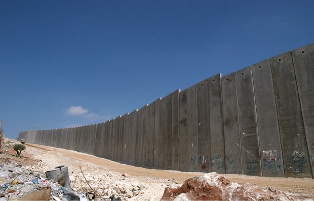
Fig. 1.1 The West Bank separation wall (17 August 2004). Photo by Justin McIntosh, CC BY 2.0.20
Goals of the West Bank Separation Wall
The sole stated purpose of the separation wall, as repeatedly declared by the Israeli government, is a temporary structure providing security21 by preventing, or at least reducing, attacks carried out by Palestinian militant groups against Israelis inside the Green Line. The decision to build the wall was taken after the outbreak of the Second Palestinian Uprising (Al-Aqsa Intifada) on 29 September 2000, when the former Likud leader Ariel Sharon, accompanied by thousands of Israeli security forces, visited the Haram Ash-Sharif, known to Jews as the Temple Mount, in al-Quds (Jerusalem). The Palestinians saw Sharon’s visit as a provocation, and a new uprising quickly spread throughout the West Bank and Gaza Strip. From this point, the Arab-Israeli conflict entered a new phase, characterized by the escalation of bombing attacks inside Israel. In 2001 and 2002, Palestinian armed groups22 carried out 87 bombings against Israeli targets, causing 299 fatalities.23
Palestinians reject Israel’s justification of the construction of the wall based on a security argument and maintain that the wall was built for political reasons: to protect and perpetuate Israel’s occupation, illegal colonies and ongoing colonization of the Palestinian land. Even if the decision to build the separation wall in 2000 was made in the context of a wave of attacks inside Israel, large numbers of the Palestinian attackers who carried out these operations passed through Israeli military checkpoints not through the porous border between Israel and the oPt.24 The Palestine Liberation Organization (PLO) argues that if Israel truly wanted to protect its citizens, it should “do one or both of the following: withdraw completely from all of the territories it occupied in 1967 or place additional security on its internationally-recognized border, rather than in the occupied Palestinian territories”.25
In addition to the wall that annexed between 10 to 15 percent of the West Bank, the Israeli settlements, in this part of the oPt, are also a land grab and contravene international law.26 As of 2004, some 54 Israeli settlements in the West Bank and 12 in East Jerusalem were located on Palestinian land that is being cut off from the rest of the West Bank by the wall and being de facto annexed to Israel. In total, more than 320,000 Israeli settlers, some 80 percent of the settlers living in the oPt, will be living on the western side of the wall and will thus enjoy more direct territorial contiguity with Israel.27 In contrast, around 67 Palestinian villages are separated from Palestinian communities, including their means of livelihood and access to government services. Some 210,000 are barred in isolated enclaves, in severe violation of their rights under international law.28 Through the construction of its separation wall, then, Israel is drawing a new de facto map and unilaterally redefining its borders.
Some argue that if it was only about a temporary security measure, Israel could construct a barbed-wire fence that would perform the same function and could easily be dismantled or destroyed, instead of a steel-reinforced concrete wall. Indeed, its cost and route both seem to disprove claims that it is a temporary structure.
Effects of the West Bank Separation Wall
The Social Impact
According to international law, Israel, as an occupying power, is obliged to respect the fundamental rights of the occupied Palestinian population at all times and to administer the Palestinian territory without making changes which could have far-reaching effects on the population or territory. The separation wall undoubtedly has a high human cost, one that is increasing still further the suffering of the Palestinian people. Since the construction of the wall began in 2002, human rights organizations have documented the immediate human impact of the wall. Reported effects, which present serious violations of both international human rights and international humanitarian law, affect various aspects of the Palestinians’ economic and social activities, including restrictions on movement, as well as the destruction and seizure of land. Amnesty International, for example, has repeatedly asserted that the wall cannot be considered a necessary or proportionate security measure and does not benefit the local Palestinian population. On the contrary, it is regarded as an act of collective punishment, which is forbidden by international humanitarian law (Article 33 of the Fourth Geneva Convention, and the restrictions allowed by Article 64 of the same Convention). Moreover, the wall has severely negative consequences for hundreds of thousands of Palestinians, including unprecedented, disproportionate and discriminatory restrictions on their movements within the oPt, as well as other violations of their fundamental rights, including the right to work, to food, to medical care, to education and to an adequate standard of living.29
Thousands of Palestinians living inside the Green Line and near the separation wall find themselves separated not only from their agricultural lands but also from their nearby communities.
A report issued by the UN Office for the Coordination of Humanitarian Affairs (OCHA) in June 2007 summarized the significant humanitarian and social effects of the separation wall on Palestinian life in the following findings:
- Palestinians from the West Bank require permits to visit the six specialist hospitals inside Jerusalem. The resulting time and difficulty this entails has meant an up to 50% drop in the number of patients visiting these hospitals.
- Entire families have been divided by the wall. Husbands and wives are separated from each other, their children and other relatives.
- Palestinian Muslims and Christians can no longer freely visit religious sites in Jerusalem. Permits are needed and are increasingly difficult to obtain.
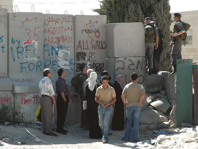
Fig. 1.2 A checkpoint in the West Bank Separation Wall, near Abu Dis (18 August 2004). Photo by Justin McIntosh, CC BY 2.0.30
School and university students struggle each day through checkpoints to reach institutions that are located on the other side of the wall. Entire communities, such as the 15,000 people in the villages of the Bir Nabala enclave, are totally surrounded by the wall. The only way in or out is through a tunnel to Ramallah which passes under the motorway that is restricted for Israeli use only.31
The Economic Effects
When construction of the wall began, studies by humanitarian organizations expected its immediate economic effects to include “a) the destruction of agricultural land and assets and water resources; b) inaccessibility to agricultural land and assets; c) added limitations on the mobility of people and goods, and therefore higher transactions costs; and d) uncertainty about the future and a consequent dampening of investment in economic activities including agriculture”.32 This was indeed the case. The Palestinian governorates adjacent to the separation wall; especially in Jenin, Tulkarm and Qalqiliya; are the most directly affected by its construction. The economic impact of the wall on these regions recorded immediately after its construction has been substantial, due principally to restrictions on farming and the inaccessibility of land by its owners. These areas, once known as the breadbasket of Palestine, are home to 37 percent of all the agricultural land in the West Bank.
Movement restrictions have proved fatal for many whose livelihoods are made in agriculture, and increased unemployment rates are seen in areas close to the wall.33 Furthermore, it is very difficult for many Palestinians to obtain a permit to enter the seam area. Even if some Palestinian farmers can get a permit to enter, they are not guaranteed regular access to their land for several reasons, including:
- Restrictions on the period of time a farmer can be in the closed areas.
- The Israeli army’s control of the gates is so erratic that this is as much a problem as the permit regime itself.
- Agricultural gates are open three times a day, generally for 20 minutes to an hour.
- Following a security incident, the gates can be closed for several days or more.
- Tractors and other farm vehicles are frequently not permitted to cross the gate. Farmers must either walk or use a donkey to reach their land and bring out produce.
- Each permit is valid for a particular gate. Some farmers have the wrong gate numbers on their permits, leaving access for the farmer reliant on a soldier’s discretion.34
In addition to the effects of the wall on agricultural activity, cutting off Palestinian communities from their primary income streams both within the West Bank and Israel has deepened the isolation of the regions adjacent to the wall. For, while the wall separates Palestinians from their farmland and water sources and impedes their movement of produce to market in other areas of the West Bank, it also makes it difficult for tens of thousands of Palestinians to access work in Israel, mainly as day laborers on farms or construction sites, a primary source of income for many. The danger is that serious economic and social effects of the wall will likely push some Palestinians to move, a form of indirect forced displacement and ethnic cleansing.
It is worth mentioning that the construction of the wall does not only affect Palestinians living in the oPt but also thousands of Palestinians living in the Green Line near the separation wall. They also find themselves cut off from their agricultural lands and their nearby compatriots both in the West Bank and across the Green Line.
The Environmental Cost
Vital environmental resources in the “seam area/buffer zone” of the separation wall are destroyed by the wall. The effects of the confiscation of water wells, the demolition of homes and greenhouses and the uprooting of hundreds of thousands of trees and crops are devastating. Palestinians argue that Israel, through the wall and its associated regime, will dominate all the strategic sites of fresh water in the region, especially in Jenin, Qalqilya and Tulkarm. The Palestinian Authority has accused Israel of planning to gain control over the most important Palestinian water resources when it set out the route of the wall.35 Palestinians therefore fear that the situation will further weaken the Palestinian position in any future negotiations over water.36
The Effect on Jerusalem
Jerusalem, which remains the thorniest issue when it comes to the resolution of the Arab-Israeli conflict, will be deeply affected by the construction of the separation wall by isolating the Holy City from its environs and the West Bank. The largest part of East Jerusalem will be swallowed and absorbed by the separation wall into Israel.37 Palestinians assert that one of the hidden goals of separating east Jerusalem from the West Bank is to control the movement of Palestinians to and from the city, thereby forcing Palestinians living there to move eastwards and out of the Palestinian capital. This would cause a dramatic change in the demographic balance of Jerusalem in favor of its Jewish population. This is part of a documented program of Judaizing the city that began in the 1970s, according to a number of studies. They assert that Israel has worked to uproot Palestinians in the Holy City and to separate Jerusalem from its geographical and historical connections.
The International Legal Status of the West Bank Separation Wall
On 8 December 2003, the UN General Assembly requested an advisory opinion from the International Court of Justice (ICJ) on the legal consequences of the construction of the Israeli separation wall, considering the rules and principles of international law, including the fourth Geneva Convention of 1949, and relevant Security Council and General Assembly resolutions. On 9 July 2004, the ICJ issued its advisory opinion on the matter, stating that the construction of the wall and its associated regime could well become permanent, notwithstanding the formal characterization of the wall by Israel, in which case it would be tantamount to a de facto annexation (para. 121).38
The court rejected Israel’s security argument since the route of the wall and its associated regime gravely infringe a number of rights of Palestinians residing in the territory occupied by Israel, and the infringements resulting from that route cannot be justified by military need or by the requirements of national security or public order (para. 137). The court also called on Israel to comply with its obligation to respect the right of the Palestinian people to self-determination and its obligations under international humanitarian law and international human rights law (para. 149). The advisory opinion of the ICJ included five main findings (para. 163):
- The construction of the wall is contrary to international law.
- Israel is under an obligation to terminate its breaches of international law; to cease forthwith the works of construction of the wall, to dismantle forthwith the structure therein situated, and to repeal or render ineffective forthwith all legislative and regulatory acts relating thereto.
- Israel is under an obligation to make reparation for all damage caused by the construction of the wall.
- All States are under an obligation not to recognize the illegal situation resulting from the construction of the wall and not to render aid or assistance in maintaining the situation created by such construction; all States parties to the Fourth Geneva Convention relative to the Protection of Civilian Persons in Time of War of 12 August 1949, have, in addition the obligation, while respecting the United Nations Charter and international law, to ensure compliance by Israel with international humanitarian law as embodied in that Convention.
- The United Nations should consider what further action is required to bring to an end the illegal situation resulting from the construction of the wall and the associated regime.
These findings were adopted almost unanimously by the fifteen participating judges of the ICJ. Two exceptions were Judge Buergenthal, who voted against the five findings, and Judge Kooijmans, who voted for the advisory opinion except the fourth finding. Given the complexity of the case and the huge levels of Israeli lobbying that came ahead of the decision, this remarkable consensus on the legal consequences of the separation wall gives these findings a significant and enduring place in the jurisprudence of the ICJ.39
Gaza Fences
Gaza has been under Israeli military occupation since the Six-Day War in 1967, even though UN Resolution 242, passed on 22 November 1967 in the aftermath of the war, called for Israel to withdraw “from territories occupied in the recent conflict”, including Gaza. Israel declared the Gaza Strip a closed military zone — a declaration that was in place until 2005 — which meant that Palestinians in Gaza had to obtain permission from Israel whenever they wanted to travel out of the closed zone. Despite Israel’s unilateral withdrawal from Gaza in 2005 and the transfer of the management of the Gaza-Egypt border crossing at Rafah to the European Union Border Assistance Mission (EUBAM), Israel continued to exercise remote control of the crossing via closed-circuit cameras until 2007. This followed Hamas’ landslide victory in the Palestinian parliamentary election of 2006 and the subsequent struggle for control between Hamas and Fatah, which saw Hamas take over the Gaza Strip in 2007. Israel’s blockade of the Gaza Strip was part of the state’s reaction to a loss of control of the enclave, but the blockade has only been possible with the acquiescence of Egypt and its leaders.
In October 1994, after a string of attacks carried by Palestinian militant groups in the coastal city of Tel Aviv, Israeli Prime Minister Yitzhak Rabin called for the construction of a fence around the Gaza Strip. The aim was both to separate Israelis from Palestinians and to cut off Gaza’s Palestinian residents from the rest of the world. Rabin based his proposal on a philosophy of separation rooted in Zionist thought by stating, “We have to decide on separation as a philosophy. There has to be a clear border. Without a border demarcating the lines, whoever wants to swallow 1.8 million Arabs will just bring greater support for Hamas”.40 Israel has built two metal barriers around the Gaza Strip, one between Israel and Gaza and the other along the border of Gaza with Egypt. The structure, constructed in 1994–1996, is 51 kilometers long and made mostly of barbed wire and corrugated sheet metal. At the beginning of 2000, al-Aqsa Intifada, Palestinian activists dismantled much of the barrier, which was rebuilt by the Israeli military between December 2000 and June 2001, with the addition of observation posts, each of which enabled soldiers to monitor an area of roughly 6 kilometers round-the-clock.41 When Israel found that the direct military occupation of the Gaza Strip was more costly than anticipated, it decided to withdraw from the Strip and maintain complete control from outside its borders, ultimately turning Gaza into an extended prison.
On the other side, and further separating Gaza from its environs, a fence was constructed along Gaza’s land border with Egypt in 2004–2005 by Israel. This came in parallel with the “unilateral withdrawal” of settlers from Gaza and the end of internal Israeli control. Israel still exercises almost complete control over Gaza’s land borders, territorial waters and airspace and prevents significant contact between the population there and the outside world. The Israeli fence between Gaza and Egypt is 11 kilometers (6.8 miles) long and 7–9 meters (about 20–30 feet) high, with several openings that allow the Israeli army to move through it under special circumstances. Because Palestinians built underground tunnels in order to smuggle items such as food and weapons from Egypt, the Israeli army equipped the fence with sophisticated technology and sensors that can detect such tunnels and aid in their destruction.42 Tunnels in Rafah on the Gaza-Egypt border manage to evade total Israeli control, despite the army’s attempts to destroy them by aerial bombardment.
The Israeli fence along Gaza’s perimeter has three main crossings through which Palestinians and their goods can enter and leave the territory: Beit Hanoun (Erez) in the north, for those going to and from Israel, imposes stringent restrictions on the movement of Palestinians; al-Montar (Karni) crossing to the east, which handles cargo and has been closed since the beginning of the al-Aqsa Intifada; and the Rafah crossing to the south, on the Egyptian border, which was monitored by the Israel Airports Authority until Israel withdrew from Gaza on 11 September 2005 as part of Israel’s unilateral disengagement plan. It was subsequently managed by the EUBAM until Hamas took over the Gaza Strip in 2007.
Evidence of the ineffectiveness of the separation fences to stop attacks emanating from Gaza can perhaps best be seen in the constant wars waged by Israel on the Strip. Despite the separation fences, regular military invasions, aerial bombings, targeted assassinations and land confiscations continue to be carried out.43 From 2006, three large-scale attacks have been waged on Gaza, the second of which, in December 2008-January 2009, killed approximately 1,417 Palestinians. The construction of the fence along the perimeter of the Gaza Strip has also not stopped attacks by Palestinian militant groups, since the organizations have adopted new means to fight Israel that include the use of surface-to-surface missiles and rockets that can reach Israeli cities on the other side of the barrier.
The barrier has failed to ensure Israeli security, has undermined Palestinian territorial integrity and caused harm to the civilian population there.
De Facto Borders: Similar Purposes in Different Contexts
Lebanon-Israel Border Fences
During the British Mandate for Palestine, double and triple barbed-wire fences along the Palestine-Lebanon border were constructed between May and June 1938 in an attempt to seal off the border against incursions from the north of Palestine. The barrier was dismantled during the 1936–1939 Arab uprisings in Palestine. At the same time, the British Mandatory authorities erected a new barbed wire called Tergart’s Wall on the northern border of Palestine to prevent Arab militants from Syria and Lebanon from joining the 1936–1939 revolt. Tergart’s Wall was abandoned and dismantled during World War II.
With the end of the British Mandate (after the establishment of the State of Israel), the Israeli government built new fences running the length of the Palestine-Lebanon border. In 1976, the government adopted a security policy toward southern Lebanon called “the Good Fence”, aimed at providing some services to southern Lebanese people, especially the Maronites, including passage into Israel for work, access to medical treatment, Israeli goods, relief support, water and food supplies44 and even military assistance and training for “those seeking to defend their community”.45 This policy was intended to support the South Lebanon Army (Maronite Militia) in its battle against the PLO during the Lebanese civil war which broke out in 1976. The “Good Fence” policy ceased to exist with the sudden withdrawal of Israeli troops from southern Lebanon in 2000.
In the 1970s, Israel built a fence without respecting the exact lines of the border inherited from the Mandate period.46 After the 1983–1984 withdrawal of Israeli troops from most of Lebanon except for the “security zone” in the south, Israel built a sophisticated defense complex along the border, consisting of electrified fences, anti-personnel minefields, patrol roads and barbed-wire obstacles.47 In March 1985, after a truck bombing in southern Lebanon killed 12 Israeli soldiers, Israel extended and moved the border fence to the northwest. The modern fence on the Israel-Lebanon border is considered the backbone of Israel’s passive defense on its northern border. The fence consists of barbed wire; movement sensors and infra-red, radio, television and electronic monitors at strategic points that can locate any intrusion within 500 meters; routine road patrols along the security road and fine sand that allows the detection of footprints.48 Though equipped with the latest technology ostensibly making infiltration nearly impossible, the fence failed to prevent Hezbollah fighters from penetrating into Israel on 12 July 2006. They killed five soldiers and took two of the bodies back north into Lebanon. The event led to the outbreak of a 34-day war between Israel and Hezbollah. Even during periods of relative calm, the de facto Israeli-Lebanon border remains a battlefield.
Egypt’s Underground Wall
In early December 2009, Egypt started, under the pretext of national security, to construct an underground steel wall that extended down 35 meters (115ft) for approximately 12 kilometers along its border with the Gaza Strip. The stated aim of the wall was to block Palestinian tunnels, which have been in operation since at least 1982. The tunnels were built during that year’s peace treaty by Palestinian families who had been divided between Israeli-occupied Gaza and Egyptian-controlled Rafah. The underground tunnels linked Gaza and Egypt as a means of communication amongst extended family members.49
The underground obstruction to these tunnels is made of steel sheets and sensors and is connected to pipes that can collapse tunnels dug into the sandy earth by saturating the ground along the border with pumped-in seawater.50 NGOs warned of an environmental disaster if the seawater pumped under the barrier leaked into the only underground freshwater wells available to the local population for drinking and agriculture purposes. The wall makes tunnel digging even more dangerous than it already was.
It has been widely reported that the underground wall was built in response to U.S. and Israeli pressure to close the tunnels, including Washington’s threat to cut military aid to Egypt over concern about arms smuggling through these passageways. The Consolidated Appropriations Act of 2008, signed into law on 26 December 2007, would have withheld USD 100 million in Foreign Military Financing from Egypt until then the U.S. Secretary of State, Condoleezza Rice, reported that Cairo had taken concrete steps to detect and destroy the smuggling tunnels leading from Egypt to Gaza.51 The U.S. military designed the wall and gave significant technical and financial assistance to the Egyptian government for its construction. In 2008, as a response to pressure from the U.S., Egypt agreed to spend USD 23 million in U.S. military aid on robots and other advanced technology to detect smuggling tunnels and accepted an American offer to send experts from the Army Corps of Engineers to train Egyptian border guards in the technology.52
However, smuggling across the Egypt-Gaza border does not pose a threat to Egyptian national security. Rather, it alleviates the suffering of the Palestinian population caused by the Israeli-imposed blockade. Egypt’s underground wall does not protect Egypt; rather it enables Cairo to protect its own interests, which means protecting the interests of the United States and, through them, of Israel. The wall strangles the only lifeline available to the Palestinians in Gaza. This has resulted in a humanitarian disaster.
Many human rights organizations have strongly condemned the construction of the underground wall, labeling it a collective punishment and therefore an offense under international humanitarian law. The UK-based Arab Organization for Human Rights (AOHR) considers the barrier’s presence to be a crime against humanity, noting that the wall aims to tighten the noose around the people of Gaza, to break their will and impose agendas which are hostile to the Palestinians’ rights to freedom and self-determination.53 Although any state has the right to build and to protect its national security, international law restricts this right to avoid damage to neighboring countries. Therefore, Egypt, because of its status as the only gateway on the other side of Gaza, is required under international law to cease the construction of the barrier and to dismantle what is already built, as well as to open the Rafah crossing to save the Gaza population from what amounts to an Israeli blockade.
Sinai Fence
In 2010, following the smuggling of tens of thousands of African migrants mainly from Sudan, Ethiopia and Eritrea across the Sinai Peninsula and into Israel, the Israeli government prepared plans for the construction of a border fence along its Sinai border with Egypt. The aim was to prevent the entry of African “infiltrators” (the stigmatizing term used by Israelis) and arms smugglers into Israeli territory. Such a fence would “secure Israel’s Jewish and democratic character” because it would stunt the growth of the non-Jewish population that could undermine its “Jewish character” and its Zionist dream.
The Israeli Ministry of Defense initially declared that by the end of 2011 the fence would cover the 240 kilometer-long porous border with Egypt.54 The main section of the fence was completed in early 2013,55 and, once fully complete, the entire fence is expected to have cost about NIS 1.5 billion (USD 395 million).56 It is constructed of barbed wire and will include high-tech surveillance cameras and radar equipment that will alert the military to intruders.
Even if infiltration of the border by African migrants has dropped significantly since the construction of the fence began in November 2010, as Israeli officials have stated,57 the system will likely increase the number of those migrants who die trying to cross into Israel through more remote desert areas in the Sinai Peninsula.
Jordan-Israel Border Fence
Until 1994, Jordan’s recognized border with Israel was based on the armistice line58 agreed to in April 1949 by Israel and what was then Transjordan, following negotiations facilitated by the UN.59 Today, the international boundary between Israel and Jordan is delimited by the Peace Treaty signed between the two sides in 1994, based on principles contained in UN Security Council resolutions 242 of 1967 and 338 of 1973, making Jordan the second Arab country after Egypt to normalize relations with Israel. The Treaty delineated the international border between Israel and Jordan with reference to the boundary defined under the British Mandate (Article 3).
Although the Israeli-Jordan border remains the least turbulent of Israel’s frontiers, it is marked by a barbed-wire fence separating the two countries from the Dead Sea to the Red Sea. Israel has not fenced its entire 238-kilometer boundary with Jordan, however, since the segment along the shore of the Dead Sea is not fenced. Much of the remaining border, though, is lined by a patrol road with fences on either side.60 Some segments of the fence were taken down following the 1994 treaty.
In March 2011, Israeli Prime Minister Benjamin Netanyahu said he had instructed the military to begin planning the construction of a new fence along the border with Jordan. Israel gives great importance to the project because, according to Netanyahu, once the fence with Egypt is erected, smugglers and infiltrators will look for alternative routes to enter Israel from the east.61 These plans are an indication of a perpetual panic and fear. Threats and insecurity simmer in a region whose people have never trusted Israel and its policies.
Israeli Military Barriers in the Occupied Arab Territories
Bar-Lev Line: The End of a Myth
After capturing the Sinai Peninsula from Egypt in the 1967 Six-Day War, Israel built a sand barrier, called the Bar-Lev Line, along the eastern bank of the Suez Canal covering a distance of 170 kilometers. Israel sought to achieve three key goals through the Bar-Lev Line: first, to maintain the military gains and geo-strategic position resulting from the 1967 war; second, to prevent any major Egyptian attack across the canal by erecting a sand wall that made the canal impassable by amphibious vehicles (without destroying the barrier); and third, to monitor Egyptian military activities on the western bank of the canal.
The Bar-Lev line, which Moshe Dayan, former Israeli Minister of Defense, once referred to as “one of the best anti-tank ditches in the world”,62 was in fact a complete military system. It was composed of 31 complex, multi-level strongholds that were each fortified with several reinforced-concrete bunkers that provided all round firing positions.63 Each fortress was staffed by more than 50 soldiers who were armed with anti-tank weapons, mortars, tanks and heavy machine guns.64 The sand wall was also equipped with wire entanglements and mine fields surrounded each fortification point that extended to a depth of 800 meters. Some points were equipped with napalm tanks giving the ability to cover the canal locally with fuel which would produce a sheet of flames one meter in height and raise the temperature of the water to boiling point.65 The construction of the Bar-Lev Line, excluding maintenance expenses, cost nearly USD 300 million.
The major dilemma faced by the Egyptian forces, when they decided to reclaim the Sinai Peninsula, was how to destroy the Bar-Lev Line. In 1971, a young Egyptian engineer officer suggested a simple yet ingenious solution: open gaps in the sand wall by using water pumps. The Egyptian Corps of Engineers combined special British and German pumps and improved them so as to effect gaps in the wall in a three-to-five hour period. During the October 1973 war,66 Egyptian forces surprised Israeli forces by making sixty huge gaps in the sand wall and overrunning the Bar-Lev Line. Instead of controlling Egyptian forces and preventing them from crossing the Suez Canal, the wall prevented Israeli forces from seeing the Egyptian attack.67 Most military analysts agree that the surprise attack launched by Egypt using innovative warfare tactics and Israel’s miscalculation regarding the effectiveness of the sand wall were the key elements that allowed Egyptian forces to destroy the Bar-Lev Line, which had been invincible barrier in the Israeli imagination.
Golan Heights Fence
After its occupation of the Golan Heights in 1967, Israel built a military barrier along its de facto border with Syria. Intended to separate the Golan from the rest of Syria, an impenetrable fence enhanced by minefields was finally completed in 1975.68 In addition to its military goals, Israel planned to use the barrier to increase its presence in the Golan Heights by establishing its first settlement in the region as part of the occupation. When Palestinian and Syrian protesters broke through the barrier and crossed the cease-fire line on the 2011 day of commemoration of the Nakba,69 as a symbolic return to their homeland, the Israeli reaction was violent; soldiers shot at the protesters, killing 35.
After this, Israel planned to construct a new barbed-wire fence east of the village of Majd al-Shams to prevent Palestinian and Syrian protesters from crossing the cease-fire line in the future. The resulting fence is 8 meters high, and 4 kilometers long on the side of Majd al-Shams and extends to Quneitra. According to Israeli officials, the Israeli military has deployed new mine fields along the de facto border with Syria since many had failed during incidents that took place on days commemorating Nakba and Naksa (previous wars with the Arab countries).70 Syria accused Israel of harming the residents of Majd al-Shams and taking over their lands in order to build a “racist separation fence” separating the Syrian-Druze population of the Golan Heights from their Syrian motherland.71 In addition, the Syrian government claimed that Israel tried to create new political and security facts on the ground in order to affect future negotiation on the future of the Israeli-occupied Golan Heights.72
The construction of the fence was regarded at that time as a pro-active move by Israel ahead of an anticipated UN vote on Palestinian statehood in October 2011. It would prevent futher storming of the cease-fire line by Palestinian and Syrian demonstrators. During the Syrian uprising that began in mid-March 2011, Israel repaired some parts of the Golan fences.
Conclusion
The separation-barrier strategy has been a key element in the construction of the Israeli state. The fencing and heavy militarization of Israel’s boundaries and the creation of security and buffer zones with Arab nations; whether in Gaza, the West Bank, Egypt, Lebanon, Syria or Jordan; are intended to perpetuate occupation and to control “the other side”. This is all in order to guarantee the security of a “Jewish state” and to protect its “Jewish character”. It also seeks the annexation of more Palestinian land, thereby defining unilaterally the borders of a future Palestinian State, continuing the ethnic cleansing of Palestinians from the oPt and diminishing the possibility of the creation of an independent and sovereign Palestinian state in the West Bank and Gaza by interrupting its territorial contiguity.
Despite the enormous efforts and the huge amounts of money spent on constructing these separation barriers, Israel has not achieved security. Israel is still living in a region whose peoples, whether in Palestine or neighboring countries, reject its existence and have shown over time that they cannot coexist or normalize their relations with the “Jewish state”. In fact, the policy of separation not only surrounds and disperses Palestinians; it also places Israel itself in a cage of its own making.
1 This chapter is drawn, with permission from the publisher, from: “Israel and the Fencing Policy: A Barrier on Every Seam Line”, research paper, Arab Center for Research and Policy Studies (June 2015), http://english.dohainstitute.org/file/get/847a306c-a229-44e4-9bc2-ad4ca6c4ffd6.pdf
2 See, for example, Uri Avnery’s critical articles on Israeli separation walls.
3 Der Judenstaat (Leipzig and Vienna: M. Breitenstein’s Verlags-Buchhandlung, 1896). English translation: The Jewish State: An Attempt at a Modern Solution of the Jewish Question, 6th ed. (New York: Maccabean Publishing Co., 1904). The title is also translated in English as The State of the Jews.
4 Theodor Herzl, The Jewish State, p. 28.
5 Uri Avnery, “First of All — the Wall must Fall”, Gush Shalom (30 August 2003).
6 It was originally published in Russian in Rassvyet [Berlin] (4 November 1923), and later translated and published in English in The Jewish Herald [South Africa] (November 26, 1937).
7 Originally published in Russian in Rassvyet [Paris] (11 November 1923), and later translated and published in English in The Jewish Standard [London] (5 September 1941).
8 Ze’ev Jabotinsky, The Iron Wall: Israel and the Arab World, cited by Yosef Gorny, Zionism and the Arabs: A Study of Ideology, Translated by Chaya Galai (Oxford: Clarendon Press, 1987), p. 166.
9 Different terms are used to denote the Israeli separation wall in the West Bank. Israeli officials and journalists generally use two terms “separation fence” and “security fence” while Palestinians use mainly “apartheid wall” or “racial separation wall” (in Arabic, jidar al-fasl al-unsuri). The International Court of Justice, in its advisory opinion, used the term “separation wall”, which I adopt in this chapter.
10 This brief chronology of the construction of the West Bank wall is based on the Yehezkel Lein’s article “Behind the Barrier: Human Rights Violations as a Result of Israel’s Separation Barrier”, position paper, Trans. Zvi Shulman, B’Tselem (March 2003), https://www.btselem.org/download/200304_behind_the_barrier_eng.pdf. See also United Nations, “Humanitarian Impact of the West Bank Barrier”, A report to the Humanitarian Emergency Policy Group (HEPG), compiled by the United Nations Office for Coordination of Humanitarian Affairs (OCHA) and the United Nations Relief and Works Agency for Palestine Refugees (UNRWA) in the occupied Palestinian territory, No. 6 (2006), https://unispal.un.org/DPA/DPR/unispal.nsf/0/1FE4606B31BC49748525713900575924
11 Samer Alatout, “Walls as Technologies of Government: The Double Construction of Geographies of Peace and Conflict in Israeli Politics, 2002-Present”, Annals of the Association of American Geographers, Vol. 99, No. 5 (2009), p. 960, http://dces.wisc.edu/wp-content/uploads/sites/30/2013/08/The-Israeli-Separation-Wall-and-Technologies-of-Government-the-Double-Construction-of-Geographies-of-Peace-and-Conflict.pdf
12 Amnesty International, “Israel and the Occupied Territories: The Place of the Fence/Wall in International Law”, https://www.amnesty.org/en/documents/MDE15/016/2004/en/
13 The 1949 Armistice lines (known also as the Green Line) refer to the demarcation lines between Israeli forces and those of neighboring Arab Countries, Egypt, Lebanon, Jordan, and Syria, which defined by the agreements that put an end to the 1984 Arab-Israeli War. These lines served as the de facto border of Israel until the 1967 war.
14 Ibid.
15 Felix Frisch, “Israel Plans: Tax to Be Imposed on Palestinians Who Enter Israel”, Y-net News (6 March 2003).
16 The information on the barrier’s structure is extracted from a report published by the Palestinian National Authority, The State Information Center, “The Israeli Racist Separation Wall: Consequences and Violations” (10 October 2003), http://w3.osaarchivum.org/galeria/the_divide/cpt14files/the_israeli_racist_separation_wall.doc. This information is consistent with what is reported in the Response of the Israeli State Attorney to the High Court of Justice in HCJ 7784/02, Sa’ al ‘Awani ‘Abd al Hadi et al. v. Commander of IDF Forces in the West Bank, sec. 23.
17 Amos Harel, “Cost of Fence could Rise to NIS 15 Million per Kilometer”, Haaretz (8 April 2004); Felix Frisch, “Israel Plans: Tax to Be Imposed on Palestinians Who Enter Israel”.
18 Article 4, Israeli Law of Return.
19 Ibid.
20 Source: Wikimedia Commons, https://commons.wikimedia.org/wiki/File%3AIsraeli_West_Bank_Barrier.jpg
21 See, for example, the Israeli Government decision of 23 July 2001 cited in the website of Israel Seam Zone Authority.
22 These attacks were carried out in particular by those affiliated with Hamas, Palestinian Islamic Jihad (PIJ), Fatah, and Popular Front for the Liberation of Palestine (PFLP).
23 Efraim Benmelech and Claude Berrebi, “Human Capital and the Productivity of Suicide Bombers”, Journal of Economic Perspectives, Vol. 21, No. 3 (2007), p. 226.
24 Palestinian Centre for Human Rights, “Securing the Wall from International Law: An Initial Response to the Israeli State Attorney”, position paper, Palestinian Centre for Human Rights (2005).
25 PLO Negotiations Affairs Department, “Bad Fences Make Bad Neighbors”, The Palestine-Israel Journal, Vol. 9, No. 3 (2002).
26 Amnesty International, “Israel and the Occupied Territories: The issue of Settlements must be Addressed according to International Law” (8 September 2003).
27 Amnesty International, “Israel and the Occupied Territories”, p. 4.
28 Yehezkel Lein, “Behind the Barrier: Human Rights Violations As a Result of Israel’s Separation Barrier”, position paper, Trans. Zvi Shulman, B’Tselem (April 2003), pp. 4–9.
29 Amnesty International, “Israel and the Occupied Territories: The Place of the Fence/Wall in International Law” (19 February 2004), p. 6
30 Source: Wikimedia Commons, https://commons.wikimedia.org/wiki/File%3ACheckpoint_near_Abu_Dis.jpg
31 Office for the Coordination of Humanitarian Affairs (OCHA) United Nations Relief and Works Agency for Palestine Refugees in the Near East (UNRWA), “Humanitarian Impact of the West Bank Barrier on Palestinian Communities”, Report No. 7 (June 2007), p. 4, https://unispal.un.org/DPA/DPR/unispal.nsf/0/1FE4606B31BC49748525713900575924
32 The Humanitarian and Emergency Policy Group (HEPG) and the Local Aid Coordination Committee (LACC), “The Impact of Israel’s Separation Barrier on Affected West Bank Communities” (4 May 2003), p. 11.
33 United Nations, “Humanitarian Impact of the West Bank Barrier”, No. 6, p. 8, https://unispal.un.org/DPA/DPR/unispal.nsf/0/1FE4606B31BC49748525713900575924
34 Ibid., p. 9.
35 Palestinian National Authority and PWA, The Israeli Apartheid Separation Wall “To Control The Palestinian Water Resources”, prepared by the PWA in cooperation with Sustainable Management of the West Bank and Gaza Aquifer (5 February 2003), p. 2.
36 Palestinian National Authority, State Information Center, “The Israeli Racist Separation Wall”, http://w3.osaarchivum.org/galeria/the_divide/cpt14files/the_israeli_racist_separation_wall.doc
37 Peter Lagerquist, “Fencing the Last Sky: Excavating Palestine after Israel’s ‘Separation Wall’”, Journal of Palestine Studies, Vol. 33, No. 2 (2004), p. 15.
38 Advisory Opinion Concerning Legal Consequences of the Construction of a Wall in the Occupied Palestinian Territory, International Court of Justice (ICJ), 9 July 2004, http://www.refworld.org/cases,ICJ,414ad9a719.html
39 Richard A. Falk, “Toward Authoritativeness: The ICJ Ruling on Israel’s Security Wall”, The American Journal of International Law, Vol. 99, No. 1 (2005), p. 43
40 David Makovsky, “How to Build a Fence”, Foreign Affairs, Vol. 83, No. 2 (2004), p. 52.
41 Doron Almog, “Lessons of the Gaza Security Fence for the West Bank”, Jerusalem Issue Brief, Jerusalem Center for Public Affairs, Vol. 4, No. 12 (2004).
42 Hanan Greenberg, “Army Building New Gaza Barrier”, Y-net News (4 April 2005), http://www.ynetnews.com/articles/0,7340,L-3072620,00.html
43 Palestinian Centre for Human Rights, “Securing the Wall from International Law: An Initial Response to the Israeli State Attorney”, position paper (April 2005).
44 Augustus Richard Norton and Jillian Schwedler, “(In) security Zones in South Lebanon”, Journal of Palestine Studies, Vol. 23, No. 1 (1993), p. 63.
45 Clive H. Schofield, “Elusive Security: The Military and Political Geography of South Lebanon”, GeoJournal, Vol. 31, No. 2 (1993), p. 155.
46 Joseph Algazy, “Soiled Hands, spoiled Lands”, Haaretz (24 December 1999) cited in Julie Trottier, “A Wall, Water and Power: the Israeli ‘Separation Fence”, Review of International Studies, Vol. 33, No. 1 (2007), p. 108.
47 David Eshel, “The Israel-Lebanon Border Enigma”, IBRU Boundary and Security Bulletin, Vol. 8, No. 4 (2000–2001), p. 80.
48 See, for example, Al J. Venter, “Israel Last Line of Defense”, Jane’s International Defense Review, Vol. 29 No. 11 (1996), p. 61; David Eshel, “Counter-guerrilla Warfare in South Lebanon”, Marine Corps Gazette, No. 1 (1997), p. 42; Julie Trottier, “A Wall, Water and Power: The Israeli ‘Separation Fence’”, Review of International Studies, p. 108.
49 Jeremy Sharp, “The Egypt-Gaza Border and its Effect on Israeli-Egyptian Relations”, Congressional Research Service, Report No. RL34346 (1 February 2008), http://www.fas.org/sgp/crs/mideast/RL34346.pdf
50 Ursula Lindsey, “Egypt’s Wall”, Middle East Research and Information Project (1 February 2010), http://www.merip.org/mero/mero020110
51 Carol Migdalovitz, “Israel: Background and Relations with the United States”, Congressional Research Service (2 April 2009), p. 19; Tally Helfont, “Egypt’s Wall with Gaza & the Emergence of a New Middle East Alignment”, ORBIS, Vol. 54, No. 3 (2010), p. 434.
52 Ellen Knickmeyer, “Egypt to Bolster Gaza Border” Washington Post (7 January 2008), http://www.washingtonpost.com/wp-dyn/content/article/2008/01/06/AR2008 010602055.html
53 Arab Organization for Human Rights in the UK (AOHR), “Special Report. Egyptian Government Infected by Mad Israeli Wall Disease” (30 December 2009), https://www.middleeastmonitor.com/wp-content/uploads/downloads/other_reports/the-arab-organisation-of-human-rights-in-the-uk-egypt-wall.pdf
54 Ben Hartman, “First Permanent Section of Sinai Border Fence Completed”, The Jerusalem Post (2 June 2011), http://www.jpost.com/Defense/First-permanent-section-of-Sinai-border-fence-completed
55 Joshua Mitnick, “Israel Finishes Most of Fence on Sinai Border”, The Wall Street Journal (2 January 2013), http://online.wsj.com/article/SB10001424127887324374004578217720772159626.html
56 Barak Ravid, “Israel to Build NIS 1.5b Fence Along Egypt Border”, Haaretz (1 October 2010), http://www.haaretz.com/israel-to-build-nis-1-5b-fence-along-egypt-border-1.261141
57 See for example: Harriet Sherwood, “Israeli border fence halts migrant flood from Egypt”, The Sydney Morning Herald, 2 January 2013, http://www.smh.com.au/world/israeli-border-fence-halts-migrant-flood-from-egypt-20130101-2c44j.html; Harriet Sherwood, “Israeli fence construction cuts off migration from Egypt”, The Guardian, 31 December 2012, https://www.theguardian.com/world/2012/dec/31/israeli-fence-cuts-migration-egypt; Miriam Valverde, “Border fence in Israel cut illegal immigration by 99 percent”, 13 February 2017, Politifact, http://www.politifact.com/truth-o-meter/statements/2017/feb/13/ron-johnson/border-fence-israel-cut-illegal-immigration-99-per/
58 The 1949 Armistice Agreements are a set of agreements signed in the year 1949 between Israel and its immediate neighbors, Egypt, Lebanon, Jordan and Syria.
59 Colonel Mazen Qojas, “Cooperative Border Security for Jordan: Assessment and Options”, Cooperative Monitoring Center Occasional Papers/8 (March 1999), p. 20, http://www.sandia.gov/cooperative-monitoring-center/_assets/documents/sand98-05058.pdf
60 Clyde R. Mark, “Israel’s Security Fences, Separating Israel from the Palestinians”, CRS Report for Congress (1 August 2003), CRS-2, https://digital.library.unt.edu/ark:/67531/metacrs7718/m1/1/high_res_d/RS21564_2003Aug01.pdf
61 Herb Keinon, “P.M. Sets Summer as Completion Date for Egypt Fence”, Jerusalem Post (15 March 2011), http://www.jpost.com/Defense/PM-sets-summer-2012-as-completion-date-for-Egypt-fence
62 Cited by George W. Gawrych, “The 1973 Arab-Israeli War: The Albatross of Decisive”, Leavenworth Papers, No. 21 [U.S. Army Center of Military History, Washington] (1996); p. 16.
63 Riad Ashkar, “The Syrian and Egyptian Campaigns”, Journal of Palestine Studies, Vol. 3, No. 2 (1974), p. 20.
64 Ibid., p. 58
65 H. El-Badri, T. El-Magdoub and M. Dia El-Din Zohdy, The Ramadan War (Dunn Loring: T. N. Dupuy Associates, Inc., 1973), p. 7.
66 The October War, also known by Arabs as the Ramadan War and by Israeli as the Yom Kippur War, launched by Egypt and Syria against Israel on 6 October 1973 to recover Sinai Peninsula and Golan Heights, which had been captured and occupied by Israel since the 1967 Six-Day War.
67 For more information about how Egyptians destroyed the bar-Lev Line see: George W. Gawrych, “The 1973 Arab-Israeli War: The Albatross of Decisive” (1996); Sa’ad Din Shazli, “How the Egyptians Crossed the Canal”, interview with Lt. General Shazli, Journal of Palestine Studies, Vol. 3, No. 2 (1974), pp. 163–68.
68 Tayseer Mara’i and Usama R. Halabi, “Life under Occupation in the Golan Heights”, Journal of Palestine Studies, Vol. 22, No. 1 (1992), p. 81.
69 Nakba means “catastrophe” in Arabic. It refers to the destruction of Palestinian society and the creation of Israel in 1948 when ten thousand Palestinians were killed and 750,000 were forced into exile.
70 See letter of Syria’s ambassador to the United Nations, Bashar Ja’afari, to UN Secretary-General and the permanent members of the UN Security Council on 8 August 2011. Cited in Barak Ravid, “Syria Calls on UN to Thwart Israel’s ‘Separation Fence’ on Golan Heights”, Haaretz (15 August 2011).
71 Ibid.
72 Ibid.

