


2. Border Fencing in India1
© 2017 Said Saddiki, CC BY 4.0 https://doi.org/10.11647/OBP.0121.03
Current national borders in South Asia are distinguished by two particular features: first, topographic diversity and, second, the arbitrariness by which European colonial powers delineated South-Asian boundaries and imposed their notions of the territorial state. The same applies to the Post-Soviet states in central Asia where borders have been demarcated unilaterally or artificially without considering preexisting ethnic, religious, linguistic, geographical, or economic conditions. As a result of these artificially created boundaries that engendered many territorial disputes and left large areas porous for a variety of irregular and illegal cross-border activities, the countries of the region have resorted to the construction of different types of barriers along their national borders in an attempt to resolve these problems. To fight cross-border security problems and unauthorized immigration largely resulting from the manner in which nation-state has been built in the region, some Asian governments, especially in South, Central and Southeast Asia, have built barriers along their national border as a simple solution to a complex problem.
In recent decades, Asian countries have seen a huge increase in cross-border drug trafficking. This is primarily due to the widespread production of drugs in the region. For example, Afghanistan has been for a long time the world’s largest producer of opium, and it is set to remain so for the foreseeable future because of the collapse of any state institutions that might impede production. Some of the region’s countries, such as Iran and Pakistan, are major transit routes for drug smuggling.
In addition to security aspects, the fencing of borders also stems from political reasons closely related to the way in which these international borders were drawn. Since many of these borders were not defined by natural landmarks, they are often easy to cross and, since they were artificially put in place and not based on a sense of cultural identity, their legitimacy is often disputed. Hence, due to border disagreements between Asian countries, fencing can also be seen as a unilateral effort to quite literally concretize these borders as de facto demarcation lines. On the other hand, some of the erected fences revive long-standing territorial disputes, especially in the Indian subcontinent.
Asian countries can be divided into two groups regarding the reasons and purposes informing the construction of land demarcations: barrier-building countries (India, Iran, Uzbekistan, China, Malaysia and Thailand) and targeted countries (Afghanistan, Bangladesh, Pakistan, Myanmar, North Korea and Kyrgyzstan). If Pakistan carries out the project of fencing its border with Afghanistan, Pakistan will be at the same time a barrier-building and a targeted country.
Like all boundaries in South Asia, India’s boundaries are also man-made2 and, as they do not clearly reflect the ethnic and geographical realities on the ground, they have led to a number of political and territorial disputes with neighboring countries.
India has 15,106 kilometers of land borders and a coastline of about 7,516 kilometers. Only 5 out of 29 Indian states have no international border or coastal line. Those long borders are shared with seven countries — China, Pakistan, Bhutan, Myanmar, Afghanistan, Nepal and Bangladesh. Such extensive and porous borders run through different kinds of terrain, including mountains, hills, plains, valleys, forest, desert and swamp, and are sometimes difficult to monitor, especially at a time when territorial disputes and security troubles still plague parts of the Indian borderline.
The situation of India’s boundaries is made more complex by the fact that its maritime boundaries are shared with seven countries — Pakistan, Maldives, Sri Lanka, Indonesia, Thailand, Myanmar and Bangladesh. With the exception of Pakistan and Bangladesh, India has ratified all its maritime borders with adjoining countries in bilateral agreements.
I divide this chapter into two main sections: the first discusses the complex situation of India’s borderline, and the second deals with the country’s strategy of fencing borders with some its neighbors.
Indian Borders between Colonial Legacy and Complex Cultural Makeup
Indian borders can be divided into three categories according to their vulnerability and the manner in which they have been drawn. History, culture and religion played a significant role in defining Indian borderlines: the first category generated from the separation movements because of cultural and religious reasons like Indo-Bangladesh and Indo-Pakistan borders. Some important parts of those borders are still disputed. The second, exemplified by the Indo-Chinese boundary, resulted from reciprocal invasions and reflect regional competition for influence and power. The third category is inherited from the colonial period and includes the Indian borders with Myanmar, Bhutan and Nepal. The latter borderline, which was established by bilateral agreement, remains peaceful to this day.
India-Bangladesh and India-Pakistan Borders: Territorial Disputes and Cultural Misunderstandings
India-Bangladesh Border
The 4,096.7 kilometers long Indo-Bangladesh border is the longest land borderline that India shares with any of its neighbors. In spite of the efforts made in the last four decades, since the secession of East Pakistan (now Bangladesh) in 1971, to demarcate the entire Indo-Bangladesh border, 6.5 kilometers remain disputed. In June 2015, the governments of the two countries exchanged instruments of ratification to make operational the 1974 Land Boundary Agreement, which was unanimously passed by the Indian parliament on May 7, 2015, marking a high point in the history of India-Bangladesh relations. The main issues had included the vague demarcation of the border and the arbitrary division of the land which resulted in Bangladesh being surrounded by India on three sides (east, north and west). The border enclaves resulting from this partition had been a significant obstacle in strengthening bilateral relations and a long-standing cause of the escalating tension between the two neighbors until the problem of these enclaves was settled in 2015.3 More importantly, the artificial delineation of the border had severely affected the traditional life of the local population who found themselves cut off from their relatives, traditional markets, agricultural land, medical facilities, etc.
The India-Bangladesh border is not the result of geographical or historical realities, but rather it reflects political and religious concerns. The partition of the Indian subcontinent in 1947 divided the population according to their religion. The secession of Pakistan — both east and west — was meant to create a state with a majority Muslim population, a goal that hasn’t been fully achieved because of the ethnic and religious communities overlapping the border and existing inside the new states. According to the 2011 Census of India, Muslims constitute 14.2 percent of India’s population with about 172 million adherents,4 whereas Hindus makes up about 8.2 percent of the Bengladeshi population according to the Bangladesh Bureau of Statistics.5
The Indo-Bangladesh border is generally marked by three different topographies: flat/plain, riverine, and hilly/jungle with virtually no natural boundaries between the two countries.6 This configuration, coupled with the porosity and length of the boundary, facilitates the irregular movement of people across the border, especially from Bangladesh, which is the main source of illegal immigrants in India. The type of settlements peppering the border represents a further challenge for India’s border surveillance as the boundary cuts through several heavily populated villages and even bisects some houses.7 Indians and Bangladeshis live side by side along the borderline separating the two countries and imposed. The high permeability of the India-Bangladesh border results in a diverse immigration flow mostly from Bangladesh to India, comprising unauthorized immigrants, refugees, and people displaced by climate. Each year, many Bangladeshis cross into India seeking employment and improved living standards, fleeing harsh environmental conditions, or escaping political and religious persecution, a situation which poses major challenges to the Indian government.
India-Pakistan Border
Similar to its boundary with Bangladesh, India shares a 3,325-kilometer border with Pakistan that runs through a diverse terrain which also facilitates illegal cross-border movement and smuggling activities in villages adjacent to the border.8 Mahmud A. Durrani, an academic and retired Pakistan Major General, distinguishes between four categories of the Pakistan-India border:9 the first is the international border, also known as the “Radcliffe line”, which is about 2,200 kilometers long and was officially recognized by the two countries in August 1947. This line defines the border between the Pakistani and Indian provinces of Punjab in the north and the Sir Creek in the south. The second type, the Working Boundary which is recognized by India as an international border, comprises the 200 kilometer-long borderline between the old Indian states of Jammu and Kashmir and Pakistan’s Punjab. The third boundary, the Line of Control (LoC) or the Ceasefire Line (CFL), is about 767 kilometers long and divides the former princely state of Kashmir into two areas — the Pakistan-controlled and the Indian-controlled regions. The fourth type of borderline, the Line of Contact (Holding), is about 95 kilometers long and represents the line of contact between the Indian and Pakistani troops fighting along the Siachen glacier.10
The border between India and Pakistan is the most sensitive of India’s borders because of the dispute over Kashmir11 which started with its annexation by India in 1947. Since then the region has fuelled a bitter dispute between the two countries. In 1954, upon India’s announcement that its accession of the region was final, the Ceasfire Line (CFL) established in 1949 that cuts through Kashmir, became the de facto border between the two states.12 Since then, India has tried a number of measures to consolidate this annexation, including erecting fences to fortify the borderline with Pakistan. Yet, this area still represents the most militarily active border in India, having been the site of three wars and one near war.
Since the partition of the sub-continent in 1947, the instability on the India-Pakistan border has soured relations between the two countries and fuelled a relentless conflict over the Kashmir region. As both India and Pakistan possess nuclear weapons and thus have the military capability to wipe each other out, the Indian subcontinent is one of the most unstable regions in the world and the dispute over Kashmir poses a constant threat of sparking an armed conflict between the two countries.
India-China Border: A Fault Line between Two Regional Powers
Although India gained its independence in 1947, it had not shared a common boundary with China until 1950 when China annexed Tibet, which was seen as a political buffer between the two countries. Since then, the entire India-China border, which extends for 3,488 kilometers, is still disputed because China has not yet recognized the controversial McMahon Line.13 The McMahon Line was drawn in 1914 to delineate the boundary Between Tibet and British India. It is recognized by India as the international border, whereas China rejects this demarcation line and claims the eastern Himalayas which is administered by India. This territorial dispute between India and China escalated in the 1950s and resulted in the 1962 war between the two countries, which ended with a new status quo border known as Line of Actual Control (LAC) that separates India from China-Tibet. As the LAC has never been delimited and due to increasing mistrust of China after the 1962 conflict, India moved towards closer relations with the U.S. and armed itself with nuclear weapons.
Because of the lack of people and goods flowing across the Chinese-Indian boundary, the management of this disputed border does not pose serious challenges to the two countries. Therefore, the erection of a fence along this border may not be on the table. Moreover, the Himalayan Mountains are natural barriers preventing significant cross-border interaction in the region.
India and China have had little political interaction throughout most of their history despite their geographical proximity. The tensions between the two nations have increased because of the dispute over the Tibet border region and escalated owing to their competing strategies and ambitions in South Asia. Given the strategic importance of the region, the two neighboring giants are expected to be in constant competition for regional leadership. Moreover, rising demand from the two countries for natural resources and energy due to their rapid industrialization and economic growth over the last two decades leads them further into competition, especially in Africa where Chinese and Indian companies are both investing more and more. The challenge is that the two countries are competing for the same resources and on the same battlefields. On the other hand, India and China have common interests in the management of international economic and financial systems. As reflected in the creation of the BRICS group, they have shown themselves to be willing to mitigate their disagreements and combine efforts with other developing countries.
India-Myanmar, India-Nepal and India-Bhutan Borders: Quiet and Stable
India-Myanmar Border
India and Myanmar share a 1,640-kilometer land border and a long maritime border in the Andaman Sea and the Bay of Bengal. The two borders were delimited and demarcated by two bilateral agreements: the land-boundary agreement signed on 10 March 1967 and ratified shortly thereafter and the maritime-boundary agreement of 1982. The India-Myanmar border, like other international Indian sub-continental frontiers, is characterized by high porosity. Additionally, the India-Myanmar border topography varies from low mountains in the south to high ridges and peaks in the north, adjacent to the Himalaya. As a result, unlike the India-Bangladesh borderland, the region is one of low population density.14
As Pushpita Das points out, the India-Myanmar border is highly vulnerable due to a number of factors. First, the boundary has not yet been concretized on the ground as lines separating two sovereign countries. Second, the border traverses a region in which numerous insurgencies operate. Thirdly, the India-Myanmar border has a unique arrangement in a place called the Free Movement Regime, which permits the tribes residing along the border to travel 16 kilometers across the boundary without visa restrictions. This place becomes a safe haven for different illegal activities like drug smuggling, human trafficking, infiltration and cross-border movements of insurgents. Finally, there is inadequate management of this border by India.15
Indo-Nepal Border
The Nepal-India boundary, which runs along the west, south and east of Nepal, is 1,580 kilometers long and dates back to the Anglo-Nepal War of 1814–1876. The Nepal-India border has been open since 1950 when the two neighboring countries signed the Nepal-India Peace and Friendship Treaty.16 The unrestricted movement of people across this border over the centuries has enhanced social and cultural ties and expanded economic and political interdependence between the two countries’ people,17 who share many commonalities. Although there are many border disputes which have not yet been resolved, the special relationship between the two countries is not seriously affected, and the movement of their people is allowed throughout the borderline.
Indo-Bhutan Border
Although the demarcation process of the 669-kilometer long India-Bhutan border took from 1961 to 2006 to establish, it is now one of the two most stable of India’s borders (the other being its border with Nepal). With the exception of a small part along the tri-junction with China, the entire India-Bhutan border is now officially demarcated.18 Bhutan is surrounded by China and India. Since its border with China is still closed because disputed territory and the absence of diplomatic relations,19 India remains the only route for Bhutan to access the outside world.
The Fencing of the Indian Borders: One Policy and Different Contexts
The common denominator that characterizes India’s border barriers is their material composition. Almost all of these barriers are made up of barbed-wire fence. Compared to most other cases, including Israeli barriers, the U.S.-Mexico border fence and fences of Ceuta and Melilla, the Indian border barriers are, in general, low tech and low cost.
Despite a diversity of goals targeted by the Indian border-fencing policy, security concerns are the top priority for its border-control systems. Security concerns encompass a wide range of illegal infiltration, including insurgency activities, terrorism, drug trafficking and organized crime. Preventing unauthorized crossings, especially those by undocumented immigrants, is the second most important purpose of the Indian border-fencing policy. The porosity of its borders and the existence of some border tribes within more than one adjacent country make India’s border control extremely challenging. Additionally, disputes over border demarcation have complicated the construction of fences in some instances. The effect of territorial disputes on the construction of border fences are clearly seen on India’s border with Pakistan and Bangladesh, where political concerns remain the key determinant of India’s border-fencing policy.
It is difficult to classify India’s border barriers into specific groups with similar characteristics because they were built within such different contexts and with differing goals. Of the large number of cases I have studied, few have much in common so each shall be addressed separately.
Fencing of the Indo-Bangladesh Border
The idea of fencing off the Indo-Bangladesh boundary dates back to the 1960s when some politicians in the Assam region proposed erecting a fence along its length in order to isolate the population of East Pakistan (now Bangladesh).20 This plan was to be executed in conjunction with a campaign launched by the Government of Assam to deport Bangladeshis settled in the region.21
Although some Islamic groups have used its porous eastern border with Bangladesh in recent years to enter India and carry out bombings, security is a minor factor in defining its fencing policy along the border with Bangladesh. Other factors, particularly the unauthorized flow of immigration, were a greater concern. Consequently, India took the decision in 1986 to fence off the entire Indo-Bangladesh border,22 which became the central component of India’s “border management strategy” — a collection of policies and practices aimed at “hardening” the border and enclosing Indian territory on its eastern periphery.23 In 1989, the Government of India initiated the first phase of building its border with Bangladesh, resulting in the erection of about 854 kilometers of fencing, almost 20 percent of the border.24 In 2000, India sanctioned phase two, which targeted the fencing of a further 2,430 kilometers. By 31 January 2005, 1,275 kilometers — about half — had been completed.25 In addition to fencing, India has also constructed a series of roads along its border with Bangladesh to facilitate the monitoring of operations. So far, roads stretching approximately 2,866 kilometers have been completed as part of phase one26 and about 2,800 kilometers of border roads and 24 kilometers of bridges are expected to be built under phase two in the states of West Bengal, Assam, Meghalaya, Tripura and Mizoram.27 The Indian Ministry of Home Affairs has admitted that most of the fence constructed in the first phase in West Bengal, Assam, and Meghalaya has been damaged due to adverse climatic conditions, notably by repeated submergence.28 Accordingly, the government of India has sanctioned a third phase of construction that would replace 861 kilometers of fencing originally built in phase one;29 532 kilometers of fencing has been replaced so far. The scheduled completion date for the entire project was March 2010,30 however, the India-Bangladesh border had not yet been entirely fenced off. The project has not been fully realized because of land-acquisition issues, public reactions, and inclement weather conditions. In 2014, the Indian Ministry of Home Affairs revised its deadline to complete fencing along the India-Bangladesh border by March 2012.31
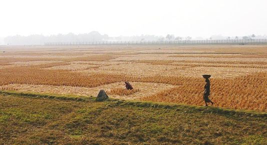
Fig. 2.1 Indo-Bangladesh Barrier (29 December 2007). Photo by Nicolas Merky, CC BY-SA 3.0.32
While some of the disputes on the interpretation and implementation of India-Bangladesh boundary have been solved, many still exist.33 Although the Indian government considers the fence as a “protective device” to prevent the influx of illegal migrants across the border, the Bangladeshi government has strongly rejected this justification. It cites the India-Bangladesh Agreement of 1975 which clearly prohibits the construction of any “defensive structure” of any kind or the deployment of any permanent or temporary border-security forces by either country in their respective territories within 150 yards of the border.34 Moreover, the Bangladeshi government claimed that the fences intruded into Bangladeshi territory at several points and constituted an attempt to appropriate its territory.35
In order to mitigate disputes between the two countries arising from the fencing project, they signed a series of agreements in 2011 aimed at reaching a common vision about the management of their border. First, in March 2011, they agreed to disallow the Border Security Force to use lethal weapons. Then, both sides signed the Coordinated Border Management Plan in July 2011 and the Protocol to the Agreement Concerning the Demarcation of Land Boundary in September 2011. Such accords are expected to transform the India-Bangladesh border from a border-management nightmare to a zone of peace and prosperity.36
Mehrotra-Khanna (2005) identified some major reasons that have rendered the India-Bangladesh border management ineffective, citing the incoherence of security personnel system, the fragility and inefficiency of different forces in charge of border control and the porosity of the frontier. She concluded that these difficulties have kept the borders vulnerable and have, in turn, facilitated problems of illegal infiltration, smuggling and trafficking.37 So, although fencing has undoubtedly made infiltration more difficult, it cannot end it.38 Smugglers and undocumented migrants have invented new ways to bypass the border security systems, including cutting the barbed wire. Additionally, the two countries share almost 200 kilometers of river border, mostly in Dhubri district of Assam and southern West Bengal, which is impossible to fence off.
In relation to the demographic composition and distribution on the India-Bangladesh borderland, fencing the border cannot be effective in checking infiltration and stopping unauthorized cross-border activities while each country has many enclaves and adverse possessions inside the other. This situation is expected to end after the 1974 Land Boundary Agreement (LBA) was finally ratified by both India and Bangladesh in June 2015. The governments of the two countries sealed the ratification pact to operationalize the LBA and exchange the enclaves.
The arbitrary and artificial nature of the Indo-Bangladesh border has been reflected in India’s security control and fencing strategy along this boundary. The erection of fencing has stopped or been delayed in the areas of 450 villages located within 150 yards of the border. Here, the construction of defensive structures or the deployment of security fences has been precluded by the 1975 Indo-Bangladesh border agreement.39 Additionally, no fewer than 200 border villages oppose the fence. In some border areas, like Hilli in the Malda district of West Bengal, a row of houses have their front doors in India and their rear doors opening into Bangladesh.40 The barbed-wire fence not only affects the social and economic life of the population and makes them refugees in their motherland but perpetuates the arbitrary nature of the border delineation.
Fencing the India-Pakistan Border
Erecting fences and installing floodlight systems are the main projects carried out by the Indian government to secure its border with Pakistan from infiltration and other illegal cross-border activities. Pakistan has always objected to India’s fence constructed along the border of Jammu and Kashmir, claiming that the barrier violates the United Nations Charter and the ceasefire agreement and alters the status of the region which Pakistan considers disputed territory.
Construction of the fences began in the late 1980s in the state of Punjab when India faced an armed Sikh separatist uprising, and weapons were being smuggled from Pakistan.41 In 1994, India pushed ahead with the construction of fences along the border of Jammu and Kashmir. The building process was stopped because of relentless Pakistani fire but resumed again along the international border in Jammu in early 2001.42 As of November 2009, of the 2,044 kilometers identified for fencing along the India-Pakistan border, 1,916 kilometers had been completed, 1,862 kilometers had been floodlit and 148 kilometers of planned floodlighting remains to be completed.43 Besides these methods of boundary control, the government of India began in 2007 to deploy more specialized technologies on all its international borders, including in Kashmir. It has implemented night-vision devices, hand-held thermal imagers, battlefield-surveillance radars, direction finders, unattended ground sensors, high-powered telescopes and more.44 According to some media resources, the fence consists of three layers and is about 3.5 meters high.45
In addition, landmines are laid along the fence as it runs from flat plains through mountainous forests.46
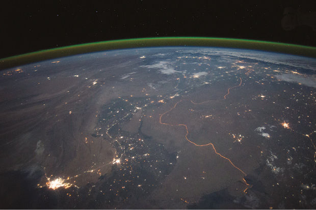
Fig. 2.2 India-Pakistan border at night (23 September 2015). NASA Earth Observatory, public domain.47
The two countries seem to take opposite approaches to the Line of Control in Jammu and Kashmir. India tries to maintain the status quo and impose the LoC as the legal international border by erecting fences and installing advanced sensors along the Line. Pakistan, meanwhile, tries to change this situation and prevent India from formalizing the LoC through both diplomatic means and proxy war. Fenced borders between the countries, however, will not be effective without Pakistan being persuaded to collaborate with India in a joint strategy to control their common boundary. The fenced border remains a temporary solution unless the issue of Kashmir itself is resolved.
Recently, the Indian government concluded, after discovered a 400-meter-long tunnel running from Pakistan into India on 28 July 2012, that its expensive security border system, including fencing, unattended ground sensors, and other gadgets, has not worked as planned and is not sufficient to monitor the country’s porous border. Accordingly, the Indian Home Ministry plans to build advanced structures to manage the country’s more than 15,000-kilometer border with China, Pakistan, Bangladesh, Nepal and Myanmar. The new system will use satellite technology and will cost more than USD 2 billion in subsequent years to manage the border.
Detecting the infiltration of Kashmiri dissidents and preventing them from carrying out attacks, whether in India or Jammu and Kashmir, remains the main reason for the building of the security fence along India’s de facto border with Pakistan. So, military and security objectives are the major determining factor in fencing and militarizing the India-Pakistan border. Other stated goals, such as the prevention of undocumented immigration and drug trafficking, are negligible.
It is worth mentioning that a decline of cross-border infiltration in Jammu and Kashmir has been noted since 2004. This is the result of not only the fencing but of political rapprochement between India and Pakistan in the last decade. Rampant corruption in border crossing and “innovative methods” used by those who cross the Indo-Pakistani border are likely to sustain illegal cross-border activities.48 The porosity of the Line of Control and its diverse geographical terrains and dense forests in some areas limit the effectiveness of the fence. Furthermore, fences cannot be erected in the high mountains in which the two neighbors could deploy some measures of cooperative monitoring.
Fencing the Myanmar-India Border
In 2003, India and Myanmar carried out a detailed survey of fencing along the international border for militancy and drug trafficking.49 By the end of 2006, a 400-kilometer border with Myanmar was already fenced and was being extended in height. In addition, a stretch of 14 kilometers near the international boundary at the border town of Moreh was identified for fencing.50 Due to recent increases in militant activities, the Government of India has decided to fence the area between BP No. 79 and 81 along the Indo-Myanma Border.51 The last section of the fence has drastically affected the traditional life of many villages located along the Myanmar border and is likely to cause serious disturbance to migratory habits of wild animals and upset their breeding cycles.52
India was primarily motivated to fence a large part of its border with Myanmar in order to stop irregular immigration and human trafficking and to disrupt the flourishing narcotic trade. The United Nations Office on Drugs and Crime (UNODC) has found that Myanmar is the second largest country for the cultivation of opium poppies (17 percent of global cultivation).53 India has traditionally been an important consumer of opium,54 the majority of which originates in Myanmar.55 The latter ranks fourth of the countries in East and South-East Asia that are most frequently cited as a source of methamphetamine.56
According to some Indian officials,57 one of the main goals aimed at by fencing the India-Myanmar border (especially in Manipur province, a state in north-eastern India) is to check the free movement of separatist rebels and new recruits to their base camps in the no-man’s-land between the two countries. Dissident movements and organized crime groups finance their activities by smuggling drugs into India in exchange for arms and ammunition and also to pay for the training of their cadres in camps run by other outfits.58 The UNODC reported in 2010 that the processing and trafficking of opiates constitute significant sources of income for insurgents in some opium-producing countries such as Myanmar.59
Besides fencing the border, India has tried to cooperate with Myanmar in managing border-related issues, including countering insurgency, policing narcotics smuggling, reducing irregular immigration, sharing intelligence and organizing training for anti-narcotics officials.60 It is noteworthy that cross-border drug trafficking in this region is not unidirectional (from Myanmar to India), rather it has grown to move in both directions. Heroin and synthetic drugs come from Myanmar to India, while chemicals like acetic anhydride and ephedrine, essential from converting raw opium into heroin, are transported from India.61 Fences are useless and ineffective in reducing illegal cross-border activities here, mainly because of the India’s long, porous and topographically hostile border with Myanmar and because of corruption among agencies responsible for border control and law enforcement.62
Conclusion
It is clear that the fortification and militarization of the Indian borders through the building of fences and related security measures has largely failed to achieve the desired outcomes. For that reason, the Indian government continues to pump money into the reform of existing systems or the adoption of new ones. Specific geographical characteristics of the Indian borders and the rampant corruption in the border-patrol forces make fencing and physically managing the border in this region extremely difficult. Additionally, fencing the bilateral boundaries is complicated by disputes over the demarcation of the border. Some countries view the fencing policy led by India as a unilateral demarcation aimed at imposing de facto borders.
Although the security challenges facing India have been driven its policy of border fortification, an impetus also exists to reinforce regional cross-border cooperation. Regional economic integration can be a solution for both territorial disputes and unauthorized cross-border movements. Such integration can blur political aspects of South Asia’s borders and transform them into spheres of economic and cultural interaction, especially in borderlands where local people have shared culture, heritage and resources. In other words, border-fencing strategies and related security measures will continue to be ineffective solutions against complicated and multifaceted problems such as undocumented migration and other illegal cross-border activities if a comprehensive policy is not put in place that takes into account the interests and rights of all parties.
1 This chapter is drawn, with permission from the publisher, from: “Border Fencing India: Between Colonial Legacy and Changing Security Challenges”, International Journal of Arts & Sciences, Vol. 7, No. 5 (2016), pp. 111–24.
2 Pushpita Das (Ed.), India’s Border Management: Select Documents, p. 1.
3 On 6 June 2015, the two countries signed a historical agreement to exchange those enclaves and allow people living in border enclaves to choose whether to reside in India or Bangladesh. There existed 51 Bangladeshi enclaves in Indian Territory and around 111 Indian enclaves inside Bangladesh. In 1974, the two countries signed a Land and Boundary Agreement in New Delhi to demarcate the border and prevent border conflicts. According to the agreement, these enclaves were to be exchanged except for Berubari, Angarpota and Dahagram. See Harun Ur. Rashid, Indo-Bangladesh Relations: An Insider’s View. New Delhi: Har-Anand Publications, 2002, p. 119.
4 Office of the Registrar General & Census Commissioner, India, Ministry of Home Affairs, Government of India, “2011 Census Data”, http://www.censusindia.gov.in/2011-Common/CensusData2011.html
5 “Population and Housing Census 2011: Socio-economic and Demographic Report”, Bangladesh Bureau of Statistics (BBS), Statistics and Informatics Division (SID), Ministry of Planning, National Series, Vol. 4 (December 2012), http://203.112.218.66/WebTestApplication/userfiles/Image/BBS/Socio_Economic.pdf
6 N. S. Jamwal, “Border Management: Dilemma of Guarding the India‐Bangladesh Border”, Strategic Analysis, Vol. 28, No. 1 (2004), p. 8.
7 Ibid., p. 9.
8 Pushpita Das (Ed.), India’s Border Management: Select Documents, p. 11.
9 Mahmud Ali Durrani, “Enhancing Security through a Cooperative Border Monitoring Experiment: A Proposal for India and Pakistan”, Cooperative Monitoring Center, Occasional Paper 21 (July 2001), p. 26. See also the following Pushpita Das book who distinguishes between three different categories of Indo-Pak border. Pushpita Das (Ed.), India’s Border Management: Select Documents, pp. 10–11.
10 Mahmud Ali Durrani, “Enhancing Security through a Cooperative Border Monitoring Experiment: A Proposal for India and Pakistan”.
11 Rick “Ozzie” Nelson (dir.), “Border Security in a Time of Transformation: Two International Case Studies—Poland and India”, A Report of the CSIS Homeland Security & Counterterrorism Program, Europe Program, and South Asia Program (July 2010), http://csis.org/files/publication/100709_Nelson_BorderSecurity_web.pdf
12 Rajat Ganguly, “India, Pakistan and the Kashmir Dispute”, working paper, Asian Studies Institute (1998), p. 3.
13 Pushpita Das (Ed.), India’s Border Management: Select Documents, p. 40.
14 U.S. State Department, Bureau of Intelligence and Research, “Burma-India Boundary”, International Boundary Study, No. 80 (15 May 1968), p. 2.
15 Pushpita Das, „India-Myanmar Border Problems: Fencing Not the Only Solution”, Institute for Defence Studies and Analyses (15 November 2013), http://www.idsa.in/idsacomments/IndiaMyanmarBorderProblems_pdas_151113.html
16 Vidya Bir Singh Kansakar, “Nepal-India Open Border: Prospects, Problems and Challenges”, Institute of Foreign Affairs [Kathmandu, Nepal] (2001), http://www.fes.de/aktuell/focus_interkulturelles/focus_1/documents/19.pdf
17 Pushpita Das (Ed.), India’s Border Management: Select Documents, p. 6.
18 Ibid., p. 8.
19 Bhutan is the only one of China’s 14 neighbors with which it doesn’t have diplomatic relations.
20 Jolin Joseph and Vishnu Narendran, “Neither Here nor There: An Overview of South-South Migration from both ends of the Bangladesh-India Migration Corridor”, working paper No. 569, Migration Literature Review, No. 1 (October 2013), p. 20.
21 Sanjoy Hazarika, Rites of Passage: Border Crossings, Imagined Homelands, India’s East and Bangladesh. New Delhi: Penguin Books, 2000, p. 117.
22 Sreeradha Datta, “Security of India’s Northeast: External Linkages”, Strategic Analysis, Vol. 24, No. 8 (2000), p. 1503.
23 Duncan McDuie-Ra, “Tribals, Migrants and Insurgents: Security and Insecurity along the India-Bangladesh Border”, Global Change, Peace & Security, Vol. 24, No. 1 (2012), p. 165.
24 Rizwana Shamshad, “Politics and Origin of the Indian-Bangladesh Border Fence”, paper presented to the 17th Biennial Conference of the Asian Studies Association of Australia, Melbourne (1–3 July 2008), p. 9; Pushpita Das. “The India-Bangladesh Border: A Problem Area for Tomorrow”, working paper, Institute for Defence Studies and Analyses, New Delhi, India (8 December 2006), http://www.idsa.in/idsastrategiccomments/TheIndiaBangladeshBorder AProblemAreaforTomorrow_PDas_081206
25 N. S. Jamwal, “Border Management: Dilemma of Guarding the India‐Bangladesh Border”, Strategic Analysis, Vol. 28, No. 1 (2004), p. 22; see also Pushpita Das, “The India-Bangladesh Border: A Problem Area for Tomorrow” (8 December 2006).
26 Ibid.
27 Willem van Schendel, The Bengal Borderland: Beyond State and Nation in South Asia. London: Anthem Press, 2005, p. 237.
28 Government of India, Ministry of Home Affairs, Annual Report 2007–2008, p. 30, http://www.satp.org/satporgtp/countries/india/document/papers/annualreport_2007-08.htm
29 Government of India, Ministry of Home Affairs, Annual Report 2009–2010, p. 30, https://www.mea.gov.in/Uploads/PublicationDocs/171_Annual-Report-2009-2010.pdf
30 Ibid.
31 “Fenced Border by 2014, Says Delhi”, The Telegraph (29 April 2013), http://www.telegraphindia.com/1130429/jsp/northeast/story_16839610.jsp#.UzdHlYXuiRo
32 Source: Wikimedia Commons, https://commons.wikimedia.org/wiki/File%3AIndo-Bangladeshi_Barrier.JPG
33 N. S. Jamwal, “Border Management: Dilemma of Guarding the India‐ Bangladesh Border”, Strategic Analysis, Vol. 28, No. 1 (2004), p. 5.
34 Hiranmay Karlekar, Bangladesh: The Next Afghanistan? New Delhi: Sage Publication, 2005, p. 88. See also N. S. Jamwal “Border Management: Dilemma of Guarding the India‐ Bangladesh Border”, p. 30.
35 V.K. Vinayaraj, “India as a Threat: Bangladesh Perceptions”, South Asian Survey, Vol. 16, No. 1 (2009), p. 107.
36 Pushpita Das, “The India-Bangladesh Border: A Problem Area for Tomorrow” (8 December 2006).
37 Mansi Mehrotra-Khanna, “Security Challenges to India-Bangladesh Relations”, working paper, Center for Land Warfare Studies (2010), p. 24.
38 Praveen Swami, “Failed Threats and Flawed Fences: India’s Military Responses to Pakistan’s Proxy War”, India Review, Vol. 3, No. 2 (2004), p. 166.
39 Chandra Moni Bhattarai, “India-Bangladesh Border Fencing and Community Responses”, conference paper, Annual International Studies Convention 2013 [Delhi, India] (10–12 December 2013).
40 Chandra Moni Bhattarai, “India-Bangladesh Border Fencing and Community Responses”, conference paper, Annual International Studies Convention 2013 (10–12 December 2013).
41 Rama Lakshmi, “India’s Border Fence Extended to Kashmir Country Aims to Stop Pakistani Infiltration”, The Washington Post (30 July 2003), http://antigenocide.org/images/India-30-Jul-03-India_s_Border_Fence_Extended_to_Kashmir.pdf
42 Sudha Ramachandran, “India: No sitting on the Fence”, Asia Times Online (3 December 2003), http://www.atimes.com/atimes/South_Asia/EL03Df05.html
43 Ravinder Singh, “Fencing and Floodlighting for Better Vigil along Borders”, The Indian Post Daily News (10 February 2010), http://www.theindiapost.com/articles/fencing-and-floodlighting-for-better-vigil-along-borders/
44 Government of India, Annual Report 2007–2008 of the Union Ministry of Home Affairs. New Delhi: Government of India (2008), p. 31, http://mha.nic.in/sites/upload_files/mha/files/pdf/ar0708-Eng.pdf
45 Binoo Joshi, “India-Pakistan Border Fence affecting Wildlife”, Indo-Asian News Service (6 February 2008), http://twocircles.net/node/78400
46 Ibid.
47 Source: Wikimedia Commons, https://commons.wikimedia.org/wiki/File:India-Pakistan_Border_at_Night.jpg
48 D. Suba Chandran and P.G. Rajamohan, “Soft, Porous or Rigid? Towards Stable Borders in South Asia”, South Asian Survey, Vol. 14, No. 1 (2007), p. 125.
49 “India, Burma to Fence the Border”, Mizzima News (17 May 2003), http://www.burmalibrary.org/TinKyi/archives/2003-05/msg00018.html
50 C. S. Kuppuswamy, “Indo-Myanmar Relations—A Review”, working paper No. 2043, South Asia Analysis Group (November 2006).
51 Indian Ministry of Home Affairs, Annual Report 2009–2010, p. 42, http://mha.nic.in/sites/upload_files/mha/files/pdf/AR(E)0910.pdf
52 “Border Fencing upsets Village Life in Moreh”, The Sangai Express (9 May 2011), http://e-pao.net/GP.asp?src=3..100511.may11
53 UNODC, World Drug Report 2010. Vienna: United Nations Publication, 2010, p. 137, https://www.unodc.org/documents/wdr/WDR_2010/World_Drug_Report_2010_lo-res.pdf
54 UNODC, “A Century of International Drug Control”, 2008, p. 15, cited in UNODC, World Drug Report 2010, p. 40, https://www.unodc.org/documents/wdr/WDR_2010/World_Drug_Report_2010_lo-res.pdf
55 UNODC, World Drug Report 2010, p. 41, https://www.unodc.org/documents/wdr/WDR_2010/World_Drug_Report_2010_lo-res.pdf
56 Ibid., p. 114.
57 See for example the statement of the Indian Major General C. A. Krishanan, Inspector General of Assam Rifles (South India) in Iboyaima Laithangbam, “Fencing along Manipur-Myanmar Border progressing”, The Hindu (8 September 2010), http://www.thehindu.com/news/national/article619798.ece
58 L. Kanchan, “Negotiating Insurgencies”, Faultlines (11 April 2002), http://www.satp.org/satporgtp/publication/faultlines/volume11/Article7.htm; Pradip Saikia, “North-East India as a Factor in India’s Diplomatic Engagement with Myanmar: Issues and Challenges”, Strategic Analysis, Vol. 33, No. 6 (2009), p. 881.
59 UNODC, World Drug Report 2010, p. 34, https://www.unodc.org/documents/wdr/WDR_2010/World_Drug_Report_2010_lo-res.pdf
60 Thin Thin Aung and Soe Myint, “India-Burma Relations”, Challenges to Democratization in Burma. Stockholm: International Institute for Democracy and Electoral Assistance, 2001, pp. 87–96.
61 Langpoklakpam Suraj Singh, “Indo-Myanmar Relations in the Greater Perspective of India’s Look East Policy: Implications on Manipur”, in Look East Policy & India’s North East: Polemics and Perspectives. Thingnam Kishan Singh (Ed.). New Delhi: Concept, 2008, p. 166; Bertil Lintner, Burma in Revolt: Opium and Insurgency since 1948. Boulder: Westview Press, 1994, p. 29.
62 L. S. Singh, “Indo-Myanmar Relations in the Greater Perspective of India’s Look East Policy: Implications on Manipur”, p. 166.

