11. The Critical Importance of Land Transport when Considering Port Development
The Case of Three Indonesian Ports
© D. Parikesit, S. Basalim, and W. W. Wibowo, CC BY 4.0 https://doi.org/10.11647/OBP.0189.11
11.0 Introduction
Over the years, academic and policy discussions on ports have moved from a traditionally single mode infrastructure analysis, to a more complex supply chain system of moving goods. The term “hinterland”, often used in relation to the areas served by seaports or river ports, derives from the German words of “hinter” or behind, and “land” or land. Hence the word hinterland loosely means an area or areas behind the urban area or a port or a major economic centre. The relationship between ports and their hinterland has become apparent since early times, when ports were a means by which to carry agricultural produce, and products from the industry sectors, and transport them outside the region. Conversely, inputs of production were required to be imported through a port and sent to cities and their hinterland to ensure efficient production of farming and manufacturing commodities.
The role of ports, and the relationship between ports and their hinterlands, has substantially evolved, with many ports (especially large, regional ports) now serving as transit ports or hub ports. The emergence of Singapore and Dubai as international hub ports has changed the economic landscape of port development. Transit or hub ports are focusing their activities as a transfer point between mother vessels serving different regions, or between a mother vessel and a smaller connecting vessel, to the cargo sending or receiving regions. This type of port has little to do with activities inland. A typical example is the Port of Singapore, which had a throughput of 30.9 million TEU in 2016,4 where 85% of its traffic is actually transshipment cargo,5 leaving only a small percentage of its traffic serving the Singapore region.
On the other hand, the Ports of Antwerp and Rotterdam have 40% of traffic generated within a 40 km and 150–200 km radius from the respective ports (Notteboom 2008), making them hinterland-serving ports with a strong manufacturing base. In the case of US Ports, container imbalance (i.e. more imports than exports) have also caused a complexity in traffic and truck management (Chen et al. 2013). This is also the case observed in the Port of Melbourne in Australia. China, on the other hand, has more exports than imports, and approximately 85% of the containers are delivered by trucks (Guan and Liu 2009, quoted in Chen et al. 2013).
In recent years, we have witnessed the emergence of a new term — “self-generating port” — which refers to an integration between a port and an industrial area, often developed as a single or joint investment. The idea of the self-generating port emerged because the business risk associated with the traffic coming from and going to its hinterland is too complicated to be mitigated by the port operator. Ports can no longer rely on the traffic generated by their hinterland but need to produce their own traffic by having manufacturing industries inside the port area supplying cargos and bulk commodities, as well as receiving them.
Whilst the ideas of regional or international hub ports and self-generating ports are appealing for both policy makers and investors, most ports still rely on their hinterland. This is due to several factors: firstly, these new types of ports are costly; and secondly, these ports require delicate coordination efforts not only between national and sub-national governments, but between governments and the private sector, especially the main industry players. Small ports in a country like Indonesia are likely to serve as hinterland ports, facilitating economic development of the region, far more than ensuring financial sustainability of those ports. The national and sub-national governments provide a large amount of subsidies to fill in the financing gap between the revenue and income from port operations. Many of the ports in Eastern Indonesia are, for instance, fully financed by the national government and treated as Public Service Agencies.6
This chapter will discuss the intricate relationship between ports and their hinterland, focusing on their transport activities. Multimodal operation of international ports will first be discussed in this chapter in the literature review, which will then be followed by an example of three ports in Indonesia namely: Belawan Port in Medan, North Sumatera; Tanjung Priok Port in Jakarta; and Tanjung Perak/Teluk Lamong Port Terminal in Surabaya.
11.1 Land Transport and Port Access: International Literature
The increasing importance of ports in regional and national development has been embedded in almost every developing and developed country’s strategy. During the cold war era, the former USSR’s strategy was to look for “warm water ports” or ports that can be accessed throughout the year. This has been the cause of conflicts and wars amongst the nations and countries in the European region. The combination of economic, socio-political, and security/defence aspects are often all amalgamated into a decision to develop and operate seaports.
China’s Maritime Silk Road policy has also opened a large debate on port geography and how countries react to the global economic expansion of a particular country (Fig. 11.1). It also allows a new player, such as a big data company (in this case is IZP), to utilise its expertise to help manage global logistics movements. The main player is no longer monopolised by port operating companies or shipping lines. Another example informed by a conventional approach is the global port network of Dubai Port (DP) World shown in Figure 11.2, which has a portfolio of seventy-seven operating marine and inland terminals supported by over fifty related businesses in forty countries across six continents with a significant presence in both high-growth and mature markets. Container handling is the company’s core business and generates more than three quarters of its revenue. In 2015, DP World handled 61.7 million TEU (twenty-foot equivalent units).
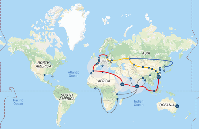
Fig. 11.1 Global Port Network of IZP and China Merchant Group. Source: adapted from http://www.izptec.com, 11 September 2019.
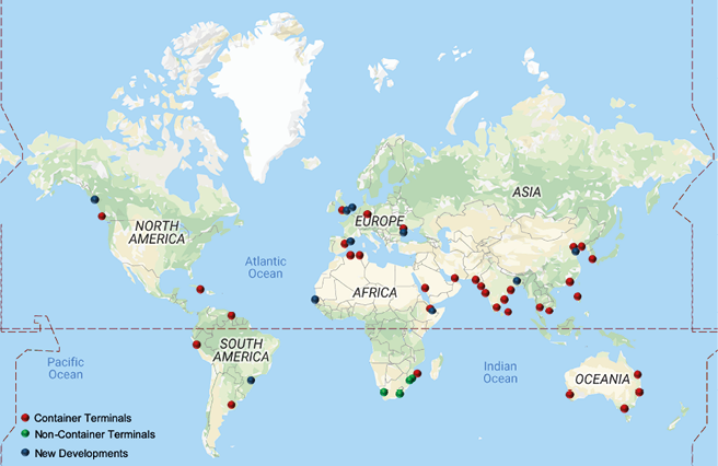
Fig. 11.2 Dubai Ports global network. Source: adapted from http://web.dpworld.com, 11 September 2019.
De Borger and de Bryune (2011) report that consolidation of ports around the world has resulted in 40% of the global market value and size represented by the “big four” terminal operators: Hutchinson, APM, PSA and P&O. This phenomena is best reflected by Notteboom (2008), who states “Port choice becomes more a function of network costs. Port selection criteria are related to the entire network in which the port is just one node. The ports that are being chosen are those that will help to minimize the sum of sea, port and inland costs, including inventory considerations of shippers” (Notteboom 2008, p. 6).
Land transport is known to operate under a less-than-equilibrium situation where many risks and uncertainties are not factored-in by both operators and regulators. The uneven level playing field between road and rail has in many countries, including in Australia, prevented the creation of a transparent market mechanism for different modes of transport to carry goods. This is where the advantage of port-to-port transport would offset the high land transport cost.
Rodrigue and Monios (in Ng et al. 2014) have indicated that the decreasing cost of ocean shipping has to some degree cross-subsidised the cost of overland transport, allowing regions distant from ports, or in countries without their own ports, to access global trade routes through intermodal links. Developments in the maritime sector influence the geography of hinterland transport in several ways: through competition for overlapping hinterlands; through attempts to improve efficiency of inland transport modes through large intermodal corridors; and through efforts to integrate supply chains by the setting of inland ports.
Table 11.1 below summarises the differences between road and rail in terms of their respective advantages and the issues related to their use.
Table 11.1 Comparisons of Advantages and Disadvantages of Road and Rail Modes
|
Pros |
Cons |
|
|
Road |
Freight can be delivered quickly as per a set schedule |
Limitations such as cargo size and weights may be applicable for road weight across various states |
|
Cost-effective and economical, especially over short distances |
May not be a cost-effective option across longer distances |
|
|
Full door to door movement |
Limitations due to weather and road conditions |
|
|
Easier option to door movement |
Not as environmentally friendly as rail |
|
|
Rail |
Greener option for transport as trains burn less fuel per ton mile than road vehicles |
Additional costs to move a container from railhead to final destination, mostly using road freight. |
|
Freight trains carry more freight at the same time compared to road transport |
Possible delays in cross-border movement due to change of train operators |
|
|
On average, long distance freight movement is cheaper and quicker by rail |
Not economically viable across shorter distances |
|
|
Freight trains have proven to be transit sensitive even more than ocean freight delivering cargo from China to Europe in as little as eighteen days, compared to forty-four days by sea. |
Abnormal cargoes cannot be moved in normal rail wagons |
The table demonstrates that the choice for road and rail is complicated and requires thorough consideration, both from the transport authorities as well as from transport operators and freight forwarders. In many instances, the solution lies in the combination of both modes.
The development of networks of ports and their associated business model has been relatively new to transport and port researchers. An extensive critical review by Ng et al. (2014) indicated that throughout the period of 1950 until 2014, researchers in transport geography have concentrated their efforts at the national and local levels. Less attention has been given to trans-national economic and political interests on port development.
While the clusters of port research are derived mostly from the discipline of transport geography, other researchers are concentrating on the following areas: the business model; the relationship between port activities and the surrounding traffic; and the ways in which interaction between those two components often results in congestion and delays in the overall port logistics. An extensive literature on port business and port operations has also appeared in discussions amongst supply chain practitioners which focus on efficiency improvement through a better financing model, simulation techniques to improve pick-up or delivery time/costs, or business integration (merger and acquisition). Another large body of research concentrates on a micro-level analysis of traffic in and around ports. In the later section of this chapter we will highlight several findings and case studies of ports and how traffic simulation can reduce the congestion in port areas.
The review of international literature in this chapter falls under three discussion topics:
- Regionalisation and spatial control.
- Structural and organisational challenges of multi-mode port operation.
- Disruption of land access to ports.
11.1.1 Regionalisation, Vertical Integration and Spatial Control of Commodities’ Flow
As ports become financially independent from the government, they need to find a solution for business sustainability. Port operators are becoming active in searching for commodities and inbound as well as outbound traffic, to ensure enough demand to fill in the capacity they provide. Competition amongst ports is another reason for operators to seek innovative ways to manage their port business. Competition brings both business opportunity and lower profit margins. The only way to survive in this kind of business environment is to position and structure the port operation so that it becomes simultaneously creative and prudent.
Wilmsmaier et al. (2011, 2014) and Monios and Wilmsmaier (2012) state that ports are required to drive as well as react to developments in both land and water spheres, but they have lost the means to influence events to the degree they once could. The extension of a port’s influence into the hinterland is one opportunity for port authorities to intervene and better influence the future. By allowing this to happen, two strategies are usually adopted: vertical and horizontal; and spatial integration.
The most common practice of control over spatial movement takes the form of an inland port, ICD (inland container depot, inland clearance depot, inland custom depot), or dry port.7 These terminologies are often used interchangeably, but all represent the “port away from port” — a facility created and managed by a port operator, served by a port operator, and, in most cases, needing to comply with port regulations. The only difference is that this facility is not near water. The inbound and outbound cargos are processed using the same protocol as for the ‘sea’ port. Thus. when goods are transported to or received from the ports, the processing time is significantly reduced, the (sea) port productivity increases and the dwell time often increases. Proponents of this concept include Roso (2007) who argued that “with dry port implementation CO2 emissions should decrease, queues at seaport terminals should be avoided, and the risk of road accidents reduced” (p. 527).
Wilmsmaier et al. (2011), however, differentiated the relationship between seaport and inland port into two types of development: Inside-Out and Outside-In. Inside-Out describes a situation where the development of the inland facility may be driven by an inland carriage company (e.g. railroad, barge, logistics service provider) or a public body (more on this below), whereas an Outside-In arrangement may be developed by port authorities, port terminal operators or ocean carriers. In practice, many of the successful projects are those following Outside-In arrangement where the port operators are the main sponsors of the initiative. The proponents of Inside-Out arrangements usually hope to achieve twin aims: increasing modal shift (thus benefitting the environment), and increased attractiveness for businesses to locate in the area (thus creating jobs and economic development in the municipality and region). Wilmsmaier’s analysis of Sweden’s Inside-Out case study shows that in the absence, or limited, interest of the Port of Gothenburg, the initiative cannot be sustainably managed. They also looked into case studies from Scotland and the USA and suggested that while new Inside-Out projects are mostly promoted by national or sub-national governments, their success will depend on the buy-in of the port operators. This prerequisite is important, as many port operators are more interested in cooperation amongst the existing inland ports than new inland ports, because inland ports are exposing commercial revenue risks of a new untested project development.
Further study by Wilmsmaier et al. (2014) identify that it is not only the relationship between inland ports and seaports that is important in this matter: it is also important to understand how the group of ports behave, since they usually respond to the market. Their work on Latin American and Caribbean (LAC) ports indicates, “It is interesting to observe that each international operator shows specific geographical specialisation strategies” (p. 217).
Dry ports in developing countries are likely to be located close to large production bases, or even inside industrial zones; and usually situated in the middle of the chain for transloading between two transport modes. (Nguyen and Notteboom 2016, p. 4). They cite the examples of Lao Chai ICD in Vietnam, and another similar case Lat Krabang in Thailand. This is slightly different than what we find in the European Union (EU), where they have established European Distribution Centres (EDC), which take care of different products with different arrangements.
11.1.2 Intermodalities and Multi-Mode Operation of Ports: Organisational and Structural Linkage between a Port and its Hinterland
Under the assumption that firms will maximise their profit and provide the best service to customers, port operators are likely to exploit the economies of scale and scope. In addition to that, ports should be strategically located in a high and balanced demand area, both in terms of inbound and outbound traffic, while continuing to invest in better technology. As pointed out by Bomba et al. (2006, p. 1):
Port users will continue to face pressure to lower production and shipping costs to remain competitive. To maintain the economic viability of their facilities, port authorities must consider improving landside linkages, as well as dockside improvements, and determine the optimal set of investments for ensuring efficiency and preventing bottlenecks.
They also argue that the important factor ensuring the success of the integration is the presence of an appropriate plan. However, in reality, efficiency needs to be gained through the private companies doing business along the supply chain. Operationally, the integration between port operations and the operation on its hinterland will be taken in the form of the business deal. Companies will take corporate actions through mergers, acquisition, alliance, joint venture or other forms of business arrangements. The ultimate functional integration will create a mega carrier. This is not a new idea.
Figure 11.3 presents an idea proposed by Robinson (2002), some fifteen years ago. Subsequently, Notteboom and Rodrigue (2005, p. 310) have systematically structured the level of integration and further predicted that:
With an increasing level of functional integration many intermediate steps in the transport chain have been removed. Mergers and acquisitions have permitted the emergence of large logistics operators that control many segments of the supply chain (mega-carriers). Technology has played a particular role in this process namely in terms of IT (information technology), control of the process, and intermodal integration (control of the flows).
In turn, it is obvious that:
The success of the port is strongly affected by the ability of the port community to fully exploit synergies with other transport nodes and other players within the logistics networks of which they are part. This observation demands closer co-ordination with logistics actors outside the port perimeter and a more integrated approach to port infrastructure planning. (Notteboom 2008, p. 37)
This raises the question whether this would be possible in the current governance and regulatory context; and how difficult it is for such complex integration to be implemented.
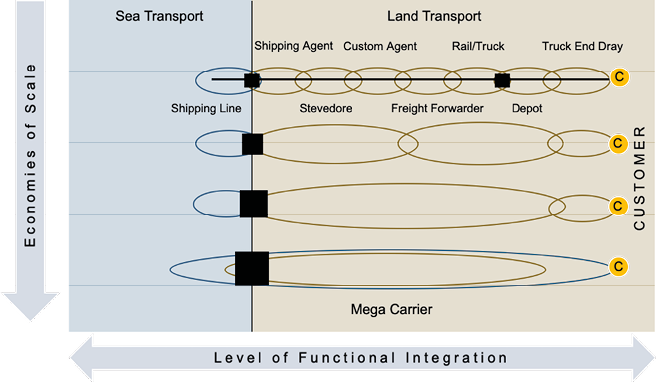
Fig. 11.3 Functional integration and exploitation of scale economies of logistics operation. Source: adapted from Robinson (2002) and Rodrigue (2006).
According to de Borger and de Bruyne (2011), the structural vertical integration of ports and transport firms will be “welfare-improving” (p. 269), only if government policies are optimal with respect to congestion tolls and port access. This implies that the private initiative for developing vertical integration will benefit both public and private sectors, but should be done in a proper and transparent manner, so that each party is aware of the price-correction policy to eliminate the imperfect market mechanism experienced in the land transport sectors. In other words, by failing to meet these criteria, either the public or the private sector will bear the risk of higher costs (i.e. lower charges will create congestion in the port periphery shouldered by the local traffic).
Other researchers argue, however, that such a simplistic approach is not useful when it comes to measuring port performance, since different ports may serve different combinations of commodities while producing the same throughput (de Langen and Sharypova 2013). Institutional barriers prevent the efficient and effective operation of an integrated port-inland system (Monios and Wilmsmeier 2012) and coordination amongst transport modes (Álvarez-SanJaime et al. 2015).
In fact, several ports investigated by de Langen and Sharypova (2013) use different PPI (port performance indicators) to reflect their productivity. To capture the land-and-seaside components of the operation, they are proposing the use of intermodal connectivity, arguing that:
Intermodal connectivity is relevant, as many ports are confronted with growth prospects while the highway infrastructure around many port areas is congested. Thus, many ports, as well as policymakers have the ambition to handle a larger share of the volumes with intermodal transport and … Many port authorities also use intermodal connections in marketing efforts for attracting customers. (Langen and Sharypova 2013, p. 99)
What was realised, but not clearly discussed and understood, is that innovation in multi modal or intermodal operation is often hampered by regulations, leaving the sector as a fragmented business. This fragmentation has often resulted in a high logistic cost.8 The mode integration alone is a challenge. OECD data on the modal split on various EU ports (quoted in Merk and Notteboom 2015) show the different combinations of road-rail-inland water transport for different ports. This suggests that different ports should have different business arrangements only from designing their mode split and should simulate the impact of that decision on the overall logistic costs or recommended port charges. Further, Merk and Notteboom (2015) identified five conditions to meet a better hinterland connection, as follows (pp. 17–18):
- Provide sufficient capacity of hinterland infrastructure and in the interface between port and hinterland infrastructure: this condition links to the infrastructural layer.
- Guarantee the efficient use of hinterland infrastructure: this condition links to the transport layer, but also supposes actions at the logistical layer in terms of coordination and orchestration.
- Good coordination of the transport chain.
- Sustainable from an environmental point of view. The sustainability condition applies to the infrastructural layer, transport layer and logistical layer.
- Attractive services (price and quality) of the service providers in the transport chain (terminal operators, carriers, …), i.e. the transport layer.
11.1.3 Traffic Congestion in and Around Ports
Road traffic congestion costs money for both transporters and freight owners. Nowadays, the cost of congestion going to or from ports is extremely high, so it becomes unreasonable to improve logistic costs without doing something on the landside. The OECD study reported by Merk and Notteboom (2015, p. 29) indicates that:
the price difference per FEU-km9 between inland transport and long-haul liner shipping ranges from a factor 5 to a factor 30, further supporting the notion that inland logistics is one of the most vital areas for the competitiveness of seaports.
Port congestion is worse in developing countries where port queuing systems have not been set according to the demand for vehicle entry, and many operations are done manually. Rajamanickam and Ramadurai (2015) studied the Port of Chennai, India and found that “congestion or queuing of trucks is due to the longer document processing and security check times that has a negative impact on the number of trucks serviced per hour” (p. 1914). The complication arises when the commodities sent or received are in the form of bulk commodities.
As opposed to the container terminal, where examination of the content and the size of the container are standardised, the bulk commodities often create difficulties, even for a modern port such as Singapore. It was observed that:
complexity is further exacerbated due to uncertain vessel arrivals, weather-dependent loading and unloading to/from vessels, and heterogeneous types of equipment and vehicles required to handle the movements of goods in and out of the port. (Li et al. 2016, p. 2382)
The simulation work by Lima et al. (2015) has provided a better understanding on how traffic management and fleet/vessel scheduling can be coordinated to reduce queuing at port gates. The latter measure, also known as Truck Arrival Management (TAM), is the procedure to arrange the arrival of the vessel so that it will reduce the waiting time. A more advance version of TAM is using vessel dependent time window (VDTM) to ensure that the information on vessel arrival is conveyed to the land transport operators (Chen et al. 2013). Many methods can be applied and one of them is applying the optimisation model for truck appointments. With this method, the terminal can manage the maximum number of trucks that can be handled in a specific time segment.
There are several policy measures available to encourage off-peak inbound and outbound traffic. Merk and Notteboom (2015) have identified several of them: for example, PierPASS in Los Angeles and Long Beach; the use of distribution centres for small ports like Gothenburg to increase the use of rail; introducing extended gates developed successfully by the Port of Antwerp; or the dedicated road freight lane in the Alameda Corridor and rail freight lane of the Betuwe Line. The importance of gate management is critical and has been discussed in various academic and practical papers.
Another example mentioned by Acciaro and McKinnon (2013) and Maguire et al. (2009) is an appointment system (or TAS, Terminal Appointment System), which generates pros and cons. The gate appointment is often complimented with the extended gate hour’s system. The supporters of TAS argue that the system brings down congestion and reduces emissions, by controlling the random arrival of trucks, modifying the peak hour demand, minimising congestion of idling trucks and improving the utilisation of terminal capacity.
The critics of the system state that the appointment system benefits the regulators but not the industry. Acciaro and McKinnon (2013, p. 9) also claim:
effectiveness of an appointment system depends on the opening hours of distribution facilities and warehouses, and to some extent on labour and road regulation.
Chen et al. (2013) further indicates that the appointment system, using a vessel-dependent time window, will not be effective if the terminal does not operate 24-hours. Another innovative solution offered is the concession agreement in the Rotterdam Port which is designed to force terminal operators to meet the modal split target by giving bonuses or imposing penalties, thus providing more push for congestion-free modes of transport.
IT technologies, including automation systems, are an important advancement in improving the movement of fleets, and perhaps will be even more important in the future, together with the advancement of autonomous vehicles. This would range from the vehicle position and recognisance system, virtual yard system, to the automatic gate web-based system that allows only a particular assigned vehicle to enter the port area (Maguire et al. 2009).
At the other end of the spectrum, the reduction of traffic going in and out of the port area can be achieved through better container arrangements or improved trans-loading activities: port-centric logistics; consolidation of container loads; and repositioning of empty containers. In the case of Miami Port, the increase in traffic volume was addressed by the construction of Port Miami Tunnel that opened on 3 August 2014. O’Rourke (2016) measured the improvement in travel speed after the tunnel was opened. He found that the travel speed improved despite an increase in traffic. Obviously, on the other hand, the costs of constructing the tunnel should be taken into account, and a proper benefit cost analysis needed to be undertaken before it was implemented.
11.2 Case Studies of Indonesian Ports
11.2.1 Case I: The Need to Manage Land Use and the Local-Through-Access Traffic Separation for Tanjung Priok Port in Jakarta
As an archipelago state, Indonesian ports are the entrance and exit gates of goods and people. Tanjung Priok Port is the main port located in North Jakarta having the highest level of activity handling more than 50% of cargo flow in Indonesia. Currently, Tanjung Priok Port has a water area of 424 hectare, including the port area and breakwater, and has 604 hectare land area. The flow of containers at Tanjung Priok Port has tended to fluctuate since 2010. Whilst it experienced a decrease between 2012 and 2015, the flow increased in 2016 where domestic and international flows reached 165,387,000 and 82,239,500 TEU respectively. However, the flow of these containers decreased in 2017 (PT Pelabuhan Tanjung Priok 2017).
The movements of goods from their origin to destination to and from Tanjung Priok Port involves containers, as stated by Decree of Directorate General of Land Transportation no. SK.538/AJ.306/DJPD/2005 (amendment of Decree no. AJ.306/1/5 of 1992), that pass through the roads of: (i) Tanjung Priok — Cilegon, (ii) Tanjung Priok — Bogor, (iii) Tanjung Priok — Cirebon, and (iv) Tanjung Priok — Pulo Gadung (Fig. 11.4). The majority of heavy vehicles traveling from outside Jakarta towards Tanjung Priok Port originate from Bekasi, Karawang, and Cikampek.
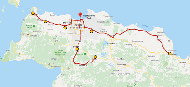
Fig. 11.4 Hinterland areas and movement corridors of containers carrying goods towards Tanjung Priok Port. Source: adapted from Tanjung Priok Port, 11 September 2019.
Currently, the majority of export industries are located towards the east of Tanjung Priok Port, i.e. Cikarang and West Karawang, handling mostly export containers (and also imported raw materials). The existing Cikampek toll road is the main route on which trucks travel. The distance between Cikarang industrial area and Tanjung Priok is around 60 km. Due to the existing congestion on the toll roads, some exporters consider taking a longer route (nearly 800 km) with less congested toll and public roads to use another international port in Surabaya (Tanjung Perak).
Considering the land area of 604 hectare covered by Tanjung Priok Port and the huge number of stakeholders involved at the Port, land management is essential. In the 2017 Master Plan of Tanjung Priok Port, the projection for containers shows that between 2020 and 2035, the volumes of containers at Tanjung Priok Port are predicted to reach 8,642,700 and 15,480,600 TEU respectively. The projection illustrates that in 2035, Tanjung Priok Terminal will reach its capacity to meet domestic and international demands. The high volumes of incoming and outgoing goods at Tanjung Priok Port require the management to improve the site to enhance its effectiveness.
The port area is the busiest area filled with heavy vehicles that impact on the performance and transport. Figure 11.5 shows the movements of heavy vehicles from the industrial areas in the hinterland that then impact heavily on the corridors leading into Tanjung Priok Port.
Figure 11.5 shows that the accumulation of heavy vehicles in industrial hinterland areas leads to a significant rise in vehicle volumes. This also leads to slower vehicle movements due to increased congestion on the roads. The combination of high volumes of traffic using toll roads, mixed use of land around the port, and local traffic has created a congested road network entering the port gate. Whilst the toll road is aimed at easing traffic from the industrial area, the traffic problem occurs when a container truck leaves the toll road and uses the public road to access the port gates. The elevated toll road known as “Access Tanjung Priok (ATP toll)”, recently built using a loan from the Japanese Government, has not been able to relieve the congestion at the port gate.
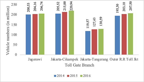
Fig. 11.5 Number of Vehicles through Toll Road by Toll Gate Branch, 2014–2016. Source: adapted from PT Jasa Marga/Indonesia Highway Corp 2018.
Of the five existing toll roads — Jagorawi; Jakarta-Cikampek; Jakarta-Tangerang; Camareng, City Toll of Jakarta, Tol Sedyatmo; Outer Toll of Jakarta — the Jakarta-Cikampek Toll Road carried the highest number of heavy vehicles among other classifications of vehicles in 2014 (Indonesia, Highway Corp, 2018). This data remained consistent in 2015 and 2016 with the average growth of 3.25% (Fig. 11.6).
11.2.1.1 Congestion around the Port of Tanjung Priok and the Failure to Comply with Land-Use Regulations
Land-use problems arise in some cities in Indonesia related to the lack of land-use controls, and the dominance of property developers to dictate the development plan and real estate. Tanjung Priok Port has the same problem where the port development area and entrance and exit access are in conflict with the surrounding non-commercial or residential areas that border the port.
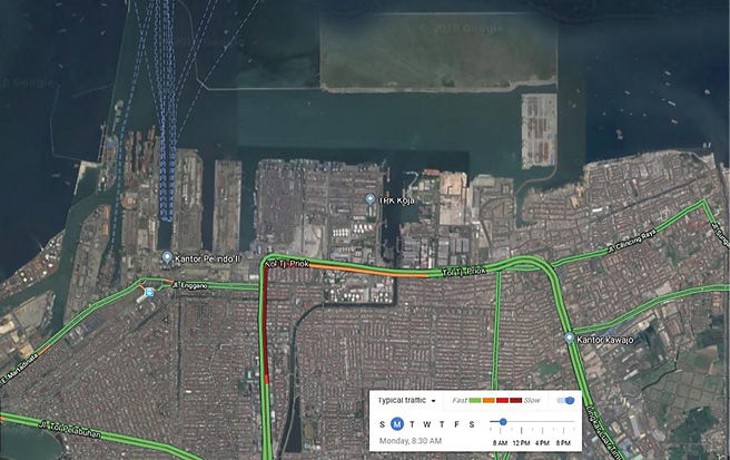
Fig. 11.6 Traffic Conditions around the Tanjung Priok Port (morning peak hour). Source: adapted from Google Maps. 11 September 2019.
From the traffic map in Figure 11.6, it can be seen that the area where the speed of vehicles around Tanjung Priok Port slows is Tanjung Priok Toll Road, where the interactions with local residents and commuters occurs in the morning peak hours. This shows the negative impact on the port region caused by the activities of the local population where there is the urgent need to access a way to and from the port. The establishment of the DLKr or Daerah Lingkungan Kerja Pelabuhan (Work Area of Port) directly adjacent to legal residential areas has created a mobility problem for container vehicles leading to and from the Tanjung Priok Port (Fig. 11.7).
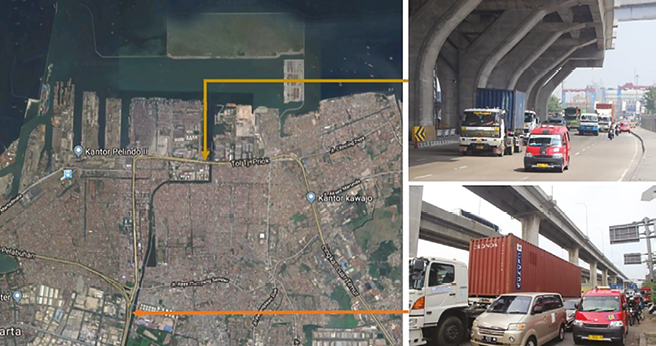
Fig. 11.7 Mix of through traffic and the movement of local traffic. Source: adapted from Google Maps, 11 September 2019.
11.2.1.2 Reactivation of Railway Access to Port Terminal
A way to improve the flow of container vehicle traffic leading from and to the port, as well as the traffic caused by the local travel, is to develop a special access road to the Port. In general, constructing toll roads is expected to provide optimal output if those toll roads are developed on an elevated basis. Separate to the construction of toll roads with access to the port, the development of railways is also important.
Tanjung Priok Port has limited access to railway services and has not made railways the main mode for freight transport. Interviews with the authority reveal that door-to-door delivery with rail is more expensive than trucks. An example is the at-grade rail intersection that disrupts the rail arrival/departure schedule, and the port loading and unloading system required by railway containers. Furthermore, the expectation of producers or exporters that the custom clearance be completed prior to entering port gates cannot be fulfilled.
11.2.1.3 The Development of Dedicated Toll Access
Figure 11.8 shows the toll road network that supports the access to Tanjung Priok Port, which is Jakarta Outer Ring Road, Tanjung Priok Access, and the Plan of Cibitung Cilincing Toll Road.
The Tanjung Priok Access Toll Road currently consists of five sections: E-1 Section for Rorotan-Cilincing along 3.4 km, E-2 Section for Cilincing-Jampea along 2.74 km, E-2A Section for Cilincing-Simpang Jampea along 1.92 km, NS Link for Yos Sudarso-Simpang Jampea along 2.24 km, and NS Direct Ramp along the 1.1 km.
The important toll road segment that will greatly assist continuous freight movement to and from Tanjung Priok Port are the two toll roads (Fig. 11.8) namely Cibitung-Cilincing (no. 11) and Tanjung Priok Access (no. 10). These two toll segments will completely separate through traffic to the Port of Tanjung Priok from the local traffic.
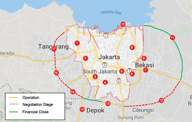
Fig. 11.8 Toll Roads Network (include Access Toll Road to Tanjung Priok Port). Source: adapted from Toll Road Management Agency, 2018.
Inland Waterways. To develop the connection between Tanjung Priok Port and its hinterland, an alternative transport mode is needed. Current connections are limited to toll roads and railways and therefore, a more modern and less costly transport mode has been suggested in the form of inland waterways. The Cikarang-Bekasi Laut (CBL) Inland Waterways will connect Tanjung Priok Port to Industrial Areas in Cibitung, Cikarang, and Karawang by utilising the CBL Canal (Fig. 11.9). The development of the water line of CBL with a total length of 25 km, consists of widening its width, dredging, and developing the Inland Terminal around Cikarang Industrial Area. This is expected to reduce congestion on the toll roads around Cibitung, Cikarang, and Karawang. In addition, it is also expected to provide a less costly but more efficient logistic solution. CBL Inland Waterway is projected to increase the volume of container flow to Tanjung Priok Port from Cibitung, Cikarang, and Karawang with a total capacity of its operational stage at 3 million TEUs annually.
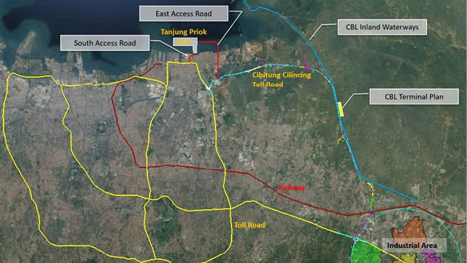
Fig. 11.9 Proposed Cikarang Bekasi Laut (CBL) Inland Waterway for container access to Tanjung Priok Port. Source: adapted from PT Pelindo II, 11 September 2019.
In Stage 1, the canal transportation system will utilise the existing canal built by the Ministry of Public Work and People Housing located in Cikarang Bekasi Sea passing through Marunda, North Jakarta. In addition, for Stage 2, PT Pelindo II (the State Owned Enterprise that owns the Port of Tanjung Priok) plans to add more routes from Tanjung Priok to Cikampek where the canal will link the logistics from Tanjung Priok and the Industrial Areas of Cibitung-Cikarang in Bekasi, Cikampek, and Karawang.
The plan to operate New Priok is an effort to optimise the capacity of Tanjung Priok from 7.1 million TEU to 10 million TEU (PT Pelabuhan Indonesia II, 2016), where the role of CBL inland waterways becomes so important. New Priok is a project implemented by PT Pelindo II undertaken through private concession to invest in the port reclaimed land and port infrastructure. CBL Inland waterways will reduce the flows of containers heading into Tanjung Priok Port since vehicles will pass through the canals and dock at the port. To optimise the use of CBL terminal, the development of Cibitung Cilincing Toll Road (Fig. 11.8) should be accelerated to relocate the container loads from land transport to the canal.
11.2.1.4 Ensuring Control of Inbound and Outbound Traffic: Pelindo II Corporate Actions
At Tanjung Priok Port, eight entrance and exit gates are operated to serve the conventional, container, and car terminals as shown in Figure 11.10.
The conventional terminal of Tanjung Priok Port has four entrance and exit gates, which are Gates 1, 3, 8, and 9:
- Gate 1 is provided for vehicles from and to the east part of the port. This Gate connects Nusantara II Street with Martadinata Street and is the main gate for vehicles leading to the conventional terminals of Nusantara I and II.
- Gate 3 links Martadinata Street and Padamarang Selatan Street and is an alternative gate for vehicles leading from the west toward Birai 1 and Birai 2. According to the short-term plan, this gate will be closed following the development of Pasoso flyover.
- Gate 8 connects Bangka Street with Enggano Street. This gate is an alternative exit gate for vehicles from the port as well as the special entrance for motorcycles.
- Gate 9 joins Port Main Street with Jampea Street where it is the main entrance and exit gate for vehicles from and to the east part mainly those that lead to the Industrial Area of KBN-Marunda, KBN-Cilincing, Cikarang, Bekasi, Cikampek, and Bekasi as well as vehicles from North Jawa Road network.
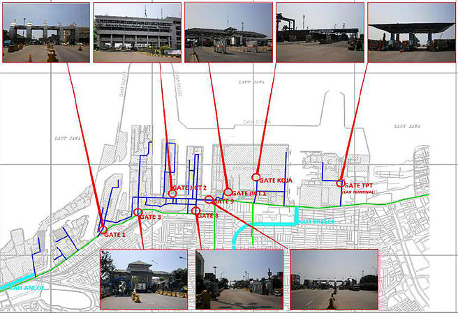
Fig. 11.10 Gates available at Tanjung Priok Port. Source: adapted from Masterplan of Tanjung Priok Port (2017).
The application of ICT can be used to control the port’s incoming and outgoing traffic, making the operational system for cargo handling more efficient. Nowadays, both sides of service — shipping and land transport — have been optimised. These two sides have been strengthened by IT where the registered trucks are allowed to enter the port with contracts to deliver or carry goods. At the same time, the docked, loading, and unloading ships can control their positions and determine the trucks that will carry their loads. This IT application under Truck Arrival Management (TAM) gives effectiveness to administration, schedules, and coordination amongst trucks and with the ship arrivals. PT Pelabuhan Tanjung Priok (PT JICT) is managing productivity and efficiency by having developed the JICT Auto Gate (Automatic Gate System) and JICT Weighing in Motion (WIM) systems, which weigh vehicles with sensors without asking the trucks to stop.
Empty Trips. If congestion at corridors leading towards the port and around the port occurs due to high volumes of trucks, this inefficient movement needs a solution. In a freight transport system, one problem is vehicles without loads. Trucks entering and leaving the port can be engaged in three different activities: pick up/export, delivery/import, and Simultaneous pick-up and Delivery (SPD). Figure 11.11 illustrates three situations related to the movements of trucks and container loads when entering and leaving the port gates. The studies previously conducted at Tanjung Priok Port (Herdian, et al. 2017) showed that empty trucks moving towards TPK (Container Terminal) Koja reached 51% (6% combo and 45% single) in 2015 and empty trucks leaving the terminal reached 44% in the same period.
In 2016, empty trucks moving towards TPK Koja reached 53% (7% combo and 46% single) and empty trucks leaving the terminal reached 45%. Here, combo means container trucks carrying two containers at the same time. The ideal condition of vehicle movements is the SPD (Simultaneous Pickup and Delivery) pattern, where the trucks entering and leaving the port are carrying loads. Greater efficiency can be achieved by equipping trucks with double loads (combo).
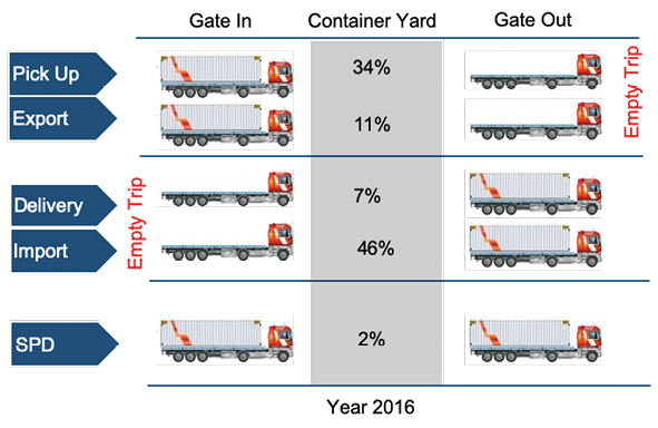
Fig. 11.11 The movement pattern of incoming and outgoing trucks at the port of Tanjung Priok. Source: adapted from Herdian et al. 2017.
The above-mentioned ‘ideal’ situation can be achieved through using IT solutions where the trucks must have two related and simultaneous tasks, which are pick up (export activity) and delivery (import activities). To reduce the number of trucks and movements at the port, it is important to optimise the existing IT by utilising it more effectively.
11.2.2 Case II: Importance of Rail Traffic to Support Efficient Operation of Belawan Port, North Sumatera
Belawan International Port is the main focus of the strategic development of the port area in Medan to support the function of Medan city10 as part of the National Centre of Activities of Mebidangro Metropolitan Region. The importance of this port is largely due to its strategic position in the north part of Sumatera, and on the busiest Malacca straight (Fig. 11.12). Currently, PT Pelindo I, a port company wholly owned by the Indonesian Government, operates Belawan Port. This port serves passenger, containers, bulk and general cargo. Pelindo I is currently developing a multi-purpose container port in another area (Kuala Tanjung) in response to the high demand for container traffic shown in Figure 11.13.
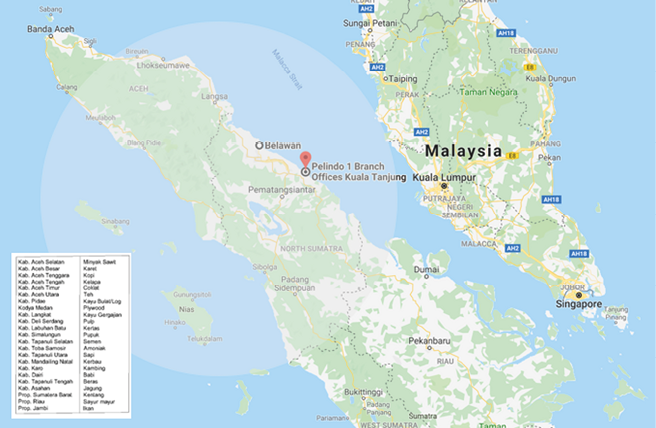
Fig. 11.12 Belawan Port and Its Hinterland. Source: adapted from Masterplan of Belawan Port, 11 September 2019.
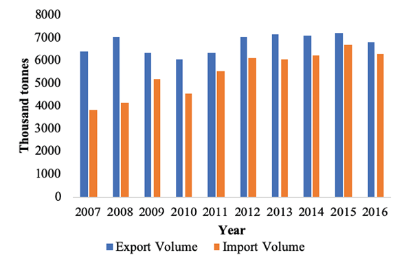
Fig. 11.13 Export and Import Volumes from Belawan Port. Source: adapted from Central Bureau Statistics of Sumatera Utara Province, 2017.
By referring to Figure 11.13, we can see the increased trends in both export and import volumes over the years, while in 2016 volume decreased. The projections for freight loads and unloads at Belawan Port (Masterplan of Port Belawan) can be seen in Table 11.2 below.
Table 11.2 Projections of cargo loads and unloads at Belawan Port
|
Description |
Year |
|
|
2025 |
2030 |
|
|
Exports |
8,266,070.54 |
10,008,680.94 |
|
Imports |
3,444,689.14 |
4,170,880.76 |
|
Inter-island Loading |
1,749,915.45 |
2,118,823.60 |
|
Inter-island Unloading |
10,301,202.88 |
12,472,849.39 |
|
Total |
23,761,878.01 |
28,771,234.69 |
Source: adapted from Masterplan of Belawan Port, 29 March 2018.
Based on data presented in Table 11.2, Belawan Port has characteristics marked by domestic incoming freight and international outgoing freight (exports) as the dominant activities. Forecast data of cargo flows can be seen in Table 11.3.
Table 11.3 Forecast data of cargo flows at Belawan International Container Terminal (BICT)
|
Year |
International |
Inter-island |
Total |
|
2020 |
963,009 |
764,157 |
1,141,915 |
|
2028 |
1,422,802 |
1,522,630 |
2,945,432 |
|
2030 |
1,568,640 |
1,809,037 |
3,377,676 |
Source: adapted Masterplan of Belawan Port, 29 March 2018.
The capacity increase of the BICT Terminal is due to the extension of its length at 700 m built in the short-term development period (2011–2015) and 1,250 m that will have been built in the middle term (2016–2025) to handle 2,900,000 TEU. Based on forecast projections, BICT will reach its maximum capacity in 2028 when the containers at BICT will be relocated to Kuala Tanjung Port. The increase of traffic in Belawan Port has resulted in demand for land transport services (Fig. 11.14). Congestion in the port area and in the existing transport corridors in the Northern part of Sumatra has increased significantly. The existing road network has not been able to cope with this demand. As a response, the government through its toll road authority is currently planning and constructing a new road network using PPP schemes and government assignments to state-owned companies.
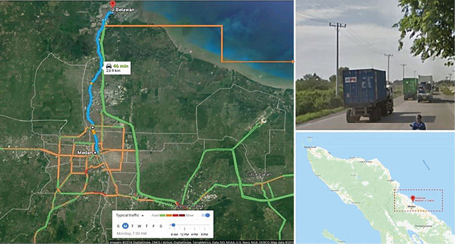
Fig. 11.14 Main Road Networks Going from and To Belawan Port. Source: adapted from Google Map, 11 September 2019.
Those important routes are Port road, Flyover/CBD Toll Road of Polonia-Belmera Toll Road, and Medan-Belawan Toll Road. The Balawan Port Action Plan projects that the average daily traffic will reach 2,340, 2,860 and 3,370 trucks in 2020, 2025 and 2030, respectively. The negative impact caused by this traffic is the congestion of 2 km of road at the main entrance gate to the port.
11.2.2.1 Sei Mangkei Special Economic Zone (SEZ) and Connectivity to Belawan Port: Railway Experience
The slow progress of toll road development is responded to by a proposal for a railway service to carry containers from Sei Mangkei Special Economic Zone (SEZ) to Belawan Port. The expectation is that, with a dedicated line, freight trains are more competitive than trucks in terms of travel time. The Industrial Area of Sei Mangkei is located at Simalungun Regency with crude palm oil (CPO) as the main source of raw material for further processing. This industrial area occupies an area of around 2,000 hectare pioneered by a state-owned company (PTPN III). The industrial area of Sei Mangkei is supported by the development of a railways system and a dry port.
Data obtained from the national railway company PT KAI Regional I of North Sumatera, for the period of January to June 2017, showed daily trips between Sei Mangkei and Belawan Port were 36 TEU (1,080 TEU on a monthly basis). Figure 11.15 contains photographs of container loading at the Sei Mangkei container yard at their inaugural railway trip to Belawan Port.
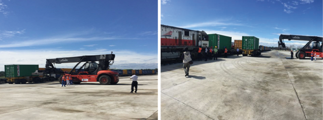
Fig. 11.15 Loading and Unloading Activities at the Industrial Area of Sei Mangkei. Photo courtesy: Danang Parikesit, 2017.
Through the development of Kuala Tanjung Port,11 the Industrial Area of Sei Mangkei has become part of the Kuala Tanjung Port hinterland. This development will accelerate the connectivity from the hinterland through to the port. Rail will be the preferred option for the transport of goods from the Industrial Area of Sei Mangke through to Kuala Tanjung Port as it has the capacity of delivery in a single trip and it will not be affected by congestion.
Existing Railway Lines. Development of the rail mode, primarily the freight trains to support Belawan Port, would benefit the freight requirements of the wide hinterland, which needs a more efficient transport mode. The railway line connecting Medan-Binjai-Besitang in North Sumatera Province is now operational. To extend the rail-based transport service, a railway connecting Aceh and North Sumatera is currently planned through the railways of Sigli-Bireun and Lhokseumawe-Langsa-Besitang servicing 417,541 km. These railways will later pass through eight regencies/cities in Aceh and one city in North Sumatra (see Fig. 11.16).
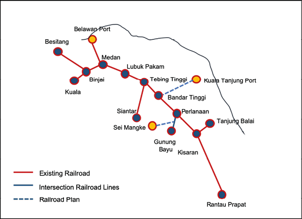
Fig. 11.16 Existing and planned railway lines in North Sumatra. Source: adapted from Masterplan of Kuala Tanjung Port, 11 September 2019.
11.2.2.2 Belawan-Kuala Tanjung Port System and the Design of Access Traffic
Pelindo I developed Kuala Tanjung Port as part of the development plan of a port system. The plan is to comprehensively develop Kuala Tanjung Port in four stages.
- Stage I: Development of Multipurpose Terminal of Kuala Tanjung (2015–2017)
- Stage II: Development of Industrial Area of 3,000 hectares (2016–2018)
- Stage III: Development of Dedicated/Hub Port (2017–2019)
- Stage IV: Development of Integrated Industrial Area
Belawan-Kuala Tanjung Proposed Toll Road. Congestion is an important consideration in an urban area and its surrounds. The development of Belawan-Kuala Tanjung Toll Road, as well as the access road from and to production centres, is important to support the connectivity and effective movements of goods. The road connection between Belawan and Kuala Tanjung Ports, as stated in the draft document of the Revised Masterplan of Belawan Port, is around 140 km in length. Considering the two existing transport modes, which are road and railway, and by combining the advantages of these concepts, the government considers a scenario of intermodal system implementation (Fig. 11.17), which can facilitate the delivery of goods through greater capacity without causing congestion.
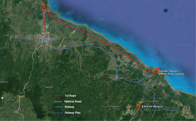
Fig. 11.17 The transportation networks of roads and railways, as well as the corridors of Belawan and Kuala Ports. Source: adapted from Google Maps, 11 September 2019.
11.2.3 Case III: Pelindo III Green Port Terminal of Teluk Lamong, Surabaya
Teluk Lamong Port Terminal, located in the Tanjung Perak Port area of Surabaya, is the first semi-automatic terminal in Indonesia using environmental-friendly technology with the green port concept. The goal in the establishment of Teluk Lamong Port Terminal is to develop Tanjung Perak Port with the aim of reducing the waiting time of ships at Tanjung Perak Port, which is the economic gate of East Java and Eastern Indonesia. The Teluk Lamong Port Terminal facilities built in Stage 1 include: a container dock (500 m x 80 m); a dry bulk dock (250 m x 30 m); a dry bulk field (7.6 ha); and a container field (24.2 ha). This terminal was built via a reclamation method with an entirely new terminal on reclaimed land. It lies around 3.5 km from the shoreline and is connected by a 2 km bridge from Tambak Osowilangun beach. The Teluk Lamong Port Terminal is part of the Port Action Plan, and integrated into Tanjung Perak Port as well as Gresik Port and Magyar Terminal in the Gresik Regency, and Socah Terminal and Tanjung Bulupandan Terminal at the Bangkalan Regency (Fig. 11.18).
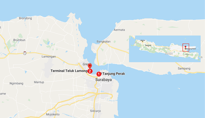
Fig. 11.18 Teluk Lamong Port Terminal (no. 2) as one of the terminals in the Operational Area of Tanjung Perak Port. Source: adapted from Pelindo III, 11 September 2019.
The increasing productivity of Teluk Lamong Port Terminal can be seen in Figure 11.19 where the recorded container flows were 1,442 and 120,688 TEU in 2014 and 2015 respectively (Pelindo III, 2016). This showed an eight-fold increase even though container flows were lower compared to those from the other ports or terminals presented in Figure 11.19.
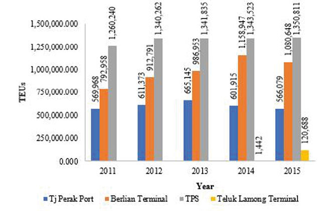
Fig. 11.19 Container Flows at Tanjung Perak Port and Teluk Lamong Port Terminal, in TEU (2011–2015). Source: adapted from Pelindo III, 29 March 2018.
This increase of productivity will affect the high volume of vehicles carrying goods entering and leaving the terminal area that need traffic management and good infrastructure. The projections of ship visits to Teluk Lamong Port Terminal in the Master Plan of Tanjung Perak Port and terminals surrounding it can be seen in Table 11.4.
Table 11.4 Projection of Ship Visit Flows to Teluk Lamong Port Terminal
|
Type of Ship |
Data Projection Output |
||
|
2020 |
2025 |
2035 |
|
|
International Containers |
365 |
775 |
1,072 |
|
Domestic Containers |
1,395 |
2,618 |
7,828 |
|
Dry Bulk |
101 |
106 |
166 |
|
Liquid Bulk of LPG |
33 |
39 |
46 |
|
Liquid Bulk of LNG |
33 |
39 |
51 |
|
Total |
1927 |
3577 |
9163 |
Source: Masterplan of Tanjung Perak Port and its surrounds, 2017.
With the projected increase in ship visits, Teluk Lamong Port Terminal will need to have a good strategy to provide optimum services to all parties utilising the port services, not only going in and out of the port area but also container movements inside the port area. The existing port has limited area for container yards: as a consequence, the port operators have several areas dedicated for container yards (empty and loaded), for the collective use by various terminals in Tanjung Perak Port. Figure 11.20 below shows the existing container movement in the port area.
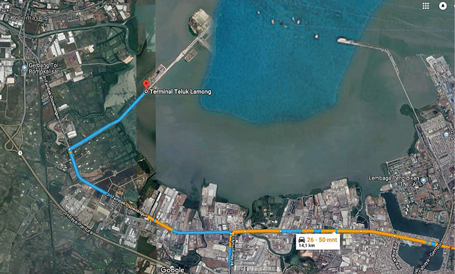
Fig. 11.20 Current Movement of Container System in Tanjung Perak Port. Source: PT Pelindo III, 11 September 2019.
11.2.3.1 The Design and Private Sector Initiative for Inter Terminal Freight Transport within Tanjung Perak Port
The high demand on freight movements, namely containers, needs infrastructure that can guarantee efficient freight movement. Congestion occurring at some points in Surabaya is caused by high flow volume of transport of goods, mainly containers, occupying some roads which have low capacities. The utilisation of the container train for efficient transportation of goods, can be a solution to overcome the movement of container boxes to Teluk Lamong.
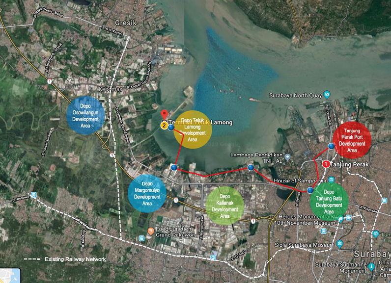
Fig. 11.21 The Application of Rail-based Container Trains as a form of transportation of goods at Teluk Lamong Port Terminal. Source: adapted from PT Terminal Teluk Lamong,11 September 2019.
As seen in Figure 11.21, it is recognised that connecting depots, which are the supporting facilities for the movement of goods by freight trains, will reduce the level of congestion on the roads. The development and operation of depots around Teluk Lamong, managed by private parties, are essential leading to the smooth relocation of activities from Tanjung Perak Port to Teluk Lamong Port Terminal. This is necessary if a good solution to the container movements is not available. The private sectors have relocated their activities to Teluk Lamong Port Terminal by building some depots around that terminal so that congestion occurring around Tanjung Perak Port will move to Teluk Lamong Port Terminal.
To accommodate the movements of these containers, besides utilising the elevated toll roads, Pelindo III plans to provide an Automatic Container Transporter (ACT). This plan will be developed as a monorail project for container movements from Tanjung Perak Port in Surabaya to Terminal Multipurpose Teluk Lamong (TMTL). This monorail will have a route length of 5.6 km and use the ACT system.
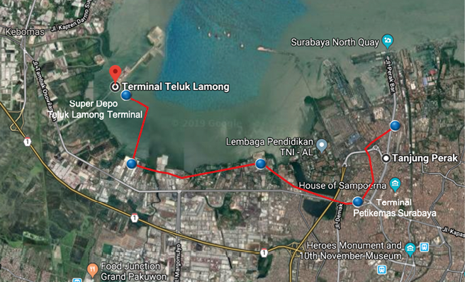
Fig. 11.22 Automatic Container Transporter Development Plan. Source: adapted from PT Teluk Lamong, 11 September 2019.
From the design shown on Figure 11.22, the container movement method between terminals will minimise the use of the road transport, by constructing most of the monorail over the bay.
Traffic Movements in and out of Tanjung Perak Port. As part of the development of Tanjung Perak Port, the Teluk Lamong Port Terminal shares the same hinterland areas, mainly all areas in East Java Province and some parts of Central Java and the Special Region of Yogyakarta Province.12 The road network around the terminal area consists of an arterial road and a toll road with a physical separator. The existing road to Teluk Lamong Port Terminal is an arterial road (Tambak Osowilangun) that connects Surabaya City and Gresik City. This is a four-lane road with two lanes in each direction. The problems related to road capacity are caused by the constriction at two points — the Osowilangun and Branjangan bridges — with their narrow width of only 8.2 m. These points restrict traffic movement around the terminal.
Improved access to the port can also be created by the construction of new road segments. The new access development is a step towards separating the heavy vehicle flows leading to the terminal from the local traffic. Considering the problem of providing enough space for roads (where there is constriction at some points along the existing road), it is difficult to create a separation by building new lanes. In the case of Teluk Lamong Port Terminal, where the toll roads exist near the terminal access, a solution is to develop a flyover and tapper13 leading to Teluk Lamong Port Terminal by integrating the existing toll roads (Fig. 11.23).
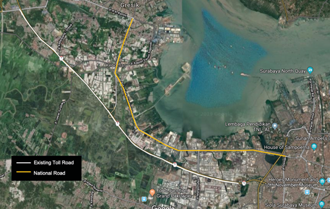
Fig. 11.23 The proposed Integrated Toll Roads to Teluk Lamong Port Terminal. Source: adapted from PT. Teluk Lamong, 11 September 2019.
This infrastructure consists of a flyover 2.4 km in length with the flyover contour of 1.8 km length, the land road at the Benowo side 363 m in length, and on the Lamong Bay side at 350 m length. The flyover width is 40 m. By building this flyover, the management of traffic movement entering and leaving Teluk Lamong Port Terminal can be improved. The current mixed traffic from and to Teluk Lamong Port Terminal with local access that is still using Artery Osowinangun Street can be avoided making the vehicle movements more efficient.
11.2.3.2 Competing Port Terminals and the Opportunity to Manage Container Traffic among Terminals
The high and stable growth of East Java Province has led to the increasing demand for port services. Many industrial areas in the region have invested heavily in constructing ports for their own use, mostly managed by Pelindo III. The expansion of ports managed by Pelindo III stretches from Gresik, Socah to Bulupandan Port Terminal. As a result, the flows of goods at Teluk Lamong Port Terminal are currently relatively low. The low operational performance of Teluk Lamong Port Terminal, as reported by the Tanjung Perak Port Authority (2016), can be shown by its Berth Occupancy Ratio (BOR) and Yard Occupancy Ratio (YOR) at 18.28% and 13.40% respectively. This is an opportunity for the Port operators and terminal operators to work collaboratively in dealing with future demand, using a combination of infrastructure and IT solutions.
11.3 Lessons Learned from the Literature and Case Studies
11.3.1 Importance of Land Connectivity in Ensuring Lower Logistics’ Costs
The international literature reviewed in this chapter has identified that, although land connectivity is considered as the most important issue in port productivity, policy intervention is often neglected, or is not the focus of the authority. In the case of Tanjung Priok Port, the government realised that land connectivity is an important element of logistics costs because 70% of the container movements, mostly for export purpose, are transported from Cikarang Industrial area to the port. Traffic performance on the existing toll road has been unsatisfactory in terms of punctuality and cost of travel. The existing dry port, which is running below its capacity, has not been successful in attracting cargo owners to use their rail facility. Another on-going initiative is using river/drainage channel transport from the industrial zones directly to the port terminal. The latter scheme is designed as a PPP to attract private investors for the project. Some of the project risk, especially demand risk, will be absorbed by the government.
Land connectivity is also important, not only because it determines the biggest cost of commodities, but also because it is a factor expressing the competitiveness of a commodity in the global market. For an island country, Indonesia will largely depend on the combination of sea and land transport in moving goods for both domestic and international market. The number of mode changes, cost of travel, time required to reach port gate, number of companies involved in moving containers or bulk products, are all factors important to consider in creating a competitive pricing. In the case of Tanjung Perak Surabaya, because of the geographical separations of different port terminals, the operator (i.e. Pelindo III and its subsidiaries) needs to find an innovative solution to deal with inter-terminal movements.
In all ports researched in these case studies, the transport authorities focused on the infrastructure solutions, ranging from rail access and elevated toll access for Tanjung Priok Jakarta port, and rail access from the special economic zone for Belawan Medan port. For Tanjung Priok port the Indonesian government has an ongoing PPP project in preparation to implement inland water transport connecting the Cikarang Industrial area directly to the port terminals. An inter-terminal container rail connection system for Tanjung Perak Surabaya has been studied for implementation.
To fulfil the needs of information technology-based transactions, Tanjung Priok Port has collaborated with PT Telkom, a state-owned telecommunication company. This partnership is manifested in a project with the Indonesia Logistic Community Service (ILCS), based on information and communication technology to create an integrated online platform. This platform covers operational, financial, technological, and human resource aspects. In addition, this helps the strategic partnership develop the National e-Trade Logistic that mainly supports the implementation of the Indonesian National Single Window.
There has not been a comprehensive study/ex-post analysis of the commercial and economic viability of the abovementioned infrastructure projects. The rail operation from the special economic zone to Belawan Medan was discontinued after several trials. The traffic volumes for the elevated toll road access are less than predicted, resulting in lower revenue to the government.
Local authorities and port operators in the three case studies presented in this chapter have not worked together on traffic management solutions despite various experiences documented in international studies.
11.3.2 Road versus Rail Connectivity to Ports, and the Role of Government Support for Commercial Rail Operations
Rail service provides technical advantages compared with road transport in delivering both bulk commodities and containers. It can provide an uninterrupted service, without exposing its services to traffic congestion, even when a grade separation is not provided. The Indonesian Railway Act has mandated authority to give top priority to rail service in land transport operations. Using the existing configuration of 12–30 carriageways of 40 TEU, the use of rail will obviously relieve the pressure of traffic congestion, reduce traffic congestion, and improve the air quality along the corridor and in the port area. However, in the two ports where rail services were introduced, both have shown unsatisfactory results. For Belawan port, the service from the special economic zone stopped after several service trials; for Tanjung Priok port, the rail service from Bandung Gedebage dry port was unsuccessful and currently services have been reduced to one train operation per day.
There are several reasons for this situation. The first reason is the imbalance of traffic from both the special economic zone and Bandung Gedebage dry port. The container traffic is dominated by one-way service from the production centres carrying outbound export products, with almost no return traffic. As a result, the cost of freight charged by the rail operator to the cargo owners is extremely high compared with the trucking service. The second reason is rail requires LO-LO (Lift On — Lift Off) service at both ends, and therefore requires a higher cost of transport imposed on cargo owners. For example, from Bandung to Jakarta using rail it takes two hours and costs USD 250 per container, whereas LO–LO service at both ends requires USD 50 per container. This means that the rail service is uncompetitive compared with direct tracking services. Thirdly, the rail infrastructure at the port area is financed by either rail operators or port operators, resulting in the need for investment recovery cost charged to the cargo owners. In various international cases, the cost of infrastructure is born by the government in order to keep rail services competitive with road transport services.
If the Indonesian government wants to keep the balance of traffic between road and rail, there are several policies that should be considered. Infrastructure investment for rail services should be separated from rail operation using a vertical separation/unbundling framework. Therefore, investment projects should be procured by government either using the government/national budget or by attracting private sector investment using PPP schemes. The second policy that should be undertaken, in cooperation with the Ministry of Industry and the Ministry of Trade, is to have a regulation on the mandatory use of rail transport for raw materials to industrial areas, especially for the import of raw materials used in export-oriented products. This regulation allows for the higher return of cargo from ports to the special economic zones, industrial areas and dry ports. This regulation will dramatically reduce the freight cost using rail to and from the ports.
There are several other policies that can be introduced. The first policy is to reduce the fuel tax for diesel use in rail operations. At the moment, the Indonesian government is applying zero fuel tax for the trucking industry and imposing industry fuel tax for rail operations. Although in recent years the government has eased the fuel tax by introducing a quota system for fuel consumed in rail operations, an excess of fuel above the quota is still charged with a fuel tax. Encouraging the transport industry to consolidate road and rail operations would create the most effective solution for cargo owners. This latter solution has already been tested by dry port operators in Cikarang. In recent years it has resulted in an increasing demand for rail services. If the government can promote the above solution across the industry, dry port with rail operations will have an opportunity to be the breakthrough needed to reduce logistics costs in Indonesia.
11.3.3 Managing Land Uses around Ports
Many ports in Indonesia were built during the Dutch colonial period and at that time, ports were situated at a distance from the city centre. The rapid growth of cities and port areas after Independence in 1945, was due to job creation in large metropolitan areas. However, the lack of land-use controls by the Indonesian Government has resulted in highly dense urban areas around ports with no separation between local and through traffic. The Spatial Plan Act was introduced in 2007 and imposed stringent controls over land use in urban areas. All local governments have to submit a spatial plan for approval by local parliaments, which comply with the National Spatial Plan of the Indonesian Government. This is an ongoing process and until today not all local governments have submitted nor received approvals from local parliament/national governments for their local spatial plans. In the case of the three ports reviewed in this study, they all suffered from this particular issue.
The recommendation to the Indonesian Government is to separate local and regional traffic as well as access traffic to the port areas. Whilst the current traffic management scheme introduced by the government of Jakarta is the “odd-and-even” number scheme for different days in a working day, the use of traffic management measures, such as lane separation, rerouting of through traffic; introducing a time windows scheme and truck appointment schemes for entering the port, can be introduced to alleviate traffic congestion around the port area. A specific traffic problem in Tanjung Priok Port in Jakarta is the fact that export activities are concentrated during the Friday-Sunday period, which is affected by international mother vessel schedules in Singapore port.
Local governments can start improving land use by relocating freight forwarding company offices to dedicated inland container depots to allow stuffing and un-stuffing activities around ports. Inland Container Depot (ICD) Lat Krabang in Thailand has provided international evidence on how relocation of container stuffing and un-stuffing activities can make transport moving to and from ports more effective. Indonesian ports could test such a solution to immediately release the pressure of congestion around ports caused by inefficient land-use configurations.
References
Acciaro, M, and McKinnon, A 2013. Efficient hinterland transport infrastructure and services for large container ports, paper presented at The International Transport Forum OECD, Paris, France.
Álvarez-SanJaime, Ó, Cantos-Sánchez, P, Moner-Colonques, R, and José J. Sempere-Monerris, JJ 2015. ‘The impact on port competition of the integration of port and inland transport services’, Transportation Research Part B: Methodological, 80, pp. 291–302, https://doi.org/10.1016/j.trb.2015.07.011
Bomba, M, Mazumder D, Hutson, N and Harrison, R 2006. Landside access needs for deepwater ports, technical report for The Center for Transportation Research, Texas, United States:The University of Texas at Austin.
de Borger, B, Proost, S and Van Dender, K 2008. ‘Private port pricing and public investment in port and hinterland capacity’, Journal of Transport Economics and Policy, 42:3, pp. 527–61, core.ac.uk/download/pdf/6978989.pdf
de Borger, B and De Bruyne, D 2011. ‘Port activities, hinterland congestion, and optimal government policies: The role of vertical integration in logistic operations’, Journal of Transport Economics and Policy, 45:2, pp. 247–75, www.jstor.org/stable/23072177
Chen, G, Govindan, K and Yang, Z 2013. ‘Managing truck arrivals with time windows to alleviate gate congestion at container terminals’, International Journal of Production Economics, 141:1 pp 179–88.
Cullinane, K and Khanna, M 2000. ‘Economies of scale in large containerships: optimal size and geographical implications’, Journal of Transport Geography, 8, pp. 181–95.
Fan, L, Wilson, WW and Dahl, B 2012. ‘Congestion, Port Expansion and Spatial Competition for US Container Imports’, Transportation Research Part E: Logistics and Transportation Review, 48, pp. 1121–36, https://doi.org/10.1016/j.tre.2012.04.006
Freightera, 2017. Shipping by road or rail: pros and cons’, www.freightera.com/blog/shipping-road-vs-rail/
Herdian, T, Kusumastanto, T, Sartono, B, Fahmiasari, H 2017. ‘Operational analysis of container truck on congestion at Tanjung Priok port’, Advances in Engineering Research (AER), 147, pp. 70–85.
de Langen, PW and Sharypova, K 2013. ‘Intermodal connectivity as a port performance indicator’, Journal of Research in Transportation Business and Management, 8, pp. 97–102, https://doi.org/10.1016/j.rtbm.2013.06.003
Li, B, Tan, KW, Tran, TK 2016. ‘Traffic simulation model for port planning and congestion prevention’, in Proceedings of the 2016 Winter Simulation Conference (T M K Roeder, P I Frazier, R Szechtman, E Zhou, T Huschka, and S E Chick, eds.), New York, USA: IEEE, pp. 2382–93.
Lima, ADP, de Mascarenhas, FW and Frazzon, EM 2015. ‘Simulation-based planning and control of transport flows in port logistic systems’, Mathematical Problems in Engineering Journal, 2015, https://doi.org/10.1155/2015/862635
Maguire, A, Ivey, S, Golias, MM, Lipinski, ME 2009. Relieving congestion at intermodal marine container terminals: Review of tactical/operational strategies’, report for the Center for Intermodal Freight Transportation Studies, Tennessee, USA: University of Memphis, pdfs.semanticscholar.org/b38f/1cdf94f612b8d1410bb7d09ce940e7bb29ee.pdf
Merk, O andNotteboom, T 2015. Port hinterland connectivity, discussion paper no. 2015–2013 presented at The International Transport Forum OECD, Paris, France.
Monios, Jand Wilmsmeier, G 2012. ‘Giving a direction to port regionalisation’, Transportation Research Part A Policy and Practice, 46, pp. 1551–561.
Monios, J and Wilmsmeier, G 2013. ‘The Role of intermodal transport in port regionalisation’, Transport Policy, 30, pp. 161–72, https://doi.org/10.1016/j.tranpol.2013.09.010
Ng, AKY, Ducruet, C, Jacobs, W, Monios, J, Notteboom, T, Rodrigue, J-P, Slack, B, Tam, K, Wilmsmeier, G 2014. ‘Port geography at the crossroads with human geography: Between flows and spaces’, Journal of Transport Geography, 41, pp. 84–96, https://doi.org/10.1016/j.jtrangeo.2014.08.012
Notteboom, TE, and Rodrigue, J-P 2005. ‘Port Regionalization: towards a new phase in port development’, Journal of Maritime Policy and Management, July–September, 32:3, pp. 297–313, https://doi.org/10.1080/03088830500139885
Notteboom, T 2008. The relationship between Seaports and the intermodal hinterland in light of global supply chains: European challenges, presented at the Research Round Table, ‘Seaport Competition and Hinterland Connections’, April 10–11, Paris, France.
O’Rourke, P 2016. ‘Examining the Impacts of the Port Miami Tunnel: A before and after study of truck counts and travel speed in the vicinity of PortMiami’, ITE Journal, 86:11, pp. 28–33.
Pelindo III, 2016. Company website of Pelindo III, www.pelindo.co.id
PT Jasa Marga/Indonesian Highway Corporation, 2018. Company website of PT Jasa Marga, www.jasamarga.com/public/id/home.aspx
PT Pelabuhan Tanjung Priok, 2017. Company website of IPC, priokport.co.id/
Rajamanickam, GD and Gitakrishnan, R 2015. ‘Simulation of truck congestion in Chennai port’, in Proceedings of the 2016 Winter Simulation Conference (TMK Roeder, PI Frazier, R Szechtman, E Zhou, T Huschka, and SE Chick, eds.), IEEE, pp. 1904–15.
Robinson R, 2002. Integrated and intermodal Freight Systems: A conceptual Framework, Proceedings of the IAME Conference, Panama.
Roso, V 2007. ‘Evaluation of the dry port concept from an environmental perspective: A note’, Transportation Research Part D Transport and Environment, 12:7, pp. 523–27, https://doi.org/10.1016/j.trd.2007.07.001
Wilmsmeier, G, Monios, J and Lambert, B 2011. ‘The directional development of intermodal freight corridors in relation to inland terminals’, Journal of Transport Geography, 19:6, pp. 1379–86, https://doi.org/10.1016/j.jtrangeo.2011.07.010
Wilmsmeier, G, Monios, J and Pérez-Salas, G 2014. ‘Port system evolution — the case of Latin America and the Caribbean’, Journal of Transport Geography, 39, pp. 208–21, https://doi.org/10.1016/j.jtrangeo.2014.07.007
Zhang, X Zeng, Q and Chen, W 2013. ‘Optimization model for truck appointment in container terminal’, Procedia — Social and Behavioral Sciences, 96, pp. 1938–47, https://doi.org/10.1155/2018/5165124
1 Professor of Transporation Engineering, Dept. of Civil and Environmental Engineering, Universitas Gadjah Mada.
2 PhD Candidate, Dept. of Civil and Environmental Engineering, Universitas Gadjah Mada.
3 Researcher at the Centre for Transportation and Logistics Studies, Universitas Gadjah Mada.
4 Singapore’s 2016 Maritime Performance, published 11 January 2017. Accessed through www.mpa.gov.sg
5 Data taken from www.singaporepsa.com.
6 A Public Service Agency or “Badan Layanan Umum” (BLU in Indonesian language) is an agency within the government department providing public service. One of the features is that it can manage their own financial affairs. It can receive payment from the user and directly use/expedite their expenses without going through the consolidated revenue in the government treasury/Ministry of Finance. BLU is required to report their net income and account statement at the end of the fiscal year. The establishment of Indonesian BLU is stipulated by the Government Regulation No 74/2012.
7 Nguyen and Notteboom (2016) classify dry ports into three categories. Close dry ports or satellite terminals are located in the proximity of seaports with strong connections to seaports by rail, barge and or trucks. Mid-range dry ports work as intermodal hubs to consolidate or deconsolidate cargo from shippers. The distant dry port is situated in the vicinity of the market, which might be the consuming area in import-based supply chains, or a core production location in export-based supply chains.
8 The World Bank indicated that Indonesia has a logistic cost of 25% of the manufacturing sales, whereas Thailand is 15% and Malaysia 15% (source: http://www.worldbank.org/en/news/press-release/2016/11/02/indonesia-400-million-approved-for-logistics-reform). Global average is believed to be between 9% and 14% depending on the industry sector. Notteboom and Rodrigue (2007) identified that “Globally, inland access costs account for 18% of the total logistics costs, and could be reduced by one third with appropriate regionalisation strategies” (p. 301).
9 FEU is forty-foot equivalent unit, as opposed to TEU twenty-foot equivalent unit.
10 As part of the National Centre of Activities of Mebidangro City Area (Decree of Medan City no. 13 Year 2011; article 12 verses 2 point d).
11 The Ministry of Transportation and the state-owned company PT Pelindo I are currently constructing a multi purpose port in Kuala Tanjung, a new port adjacent to the SEZ Sei Mangkei. The container port terminal is planned to be financed using PPP scheme.
12 Executive Summary Review of Tanjung Perak Master Plan, July 2017.

