5. Roads
© John Andrew Black, CC BY-NC 4.0 https://doi.org/10.11647/OBP.0281.05
Kono michi ya
Yuku hito nashi ni
Aki no kure1
Bashō, 1694, quoted by Bamhill, 2004: 150
Introduction
This chapter describes the institutional arrangements for ancient and modern roads and the organisations that emerged to administer roads and to transport goods around the country. Unless there was river access, the transfer of people and goods to and from the ports into their hinterlands required rudimentary tracks for porters and for horses. As in many countries, documentary evidence on early road administration is sparse but from Chapter 2 it is clear that the local ruling elites directed slaves or coerced peasants into repairing sections of ancient highways or tracks damaged by natural disasters such as earthquakes, typhoons and floods.
The sengoku-daimyō made extensive capital works improvements in their domains including road improvements. However, a major obstacle to the development of a modern capitalistic system in Japan was the problem of access to a free, national road network. For example, in the Edō period the bakufu administered road policy by regulating barrier stations and post stations and issuing passports to the population of artisans, farmers and merchants. An enduring government policy instrument has been barrier stations (sekisho) and a long section describes their policy objectives drawn from the research by Vaporis (1994).
The subject is covered in the Japanese language by Takebe (2015). Barriers on roads were first established as a government instrument in the Yamato State then expanded into a system of government-controlled barrier stations established after the Taika Reform of 645 that were finally abolished in the 19th century. With the transfer of the capital of the Tokugawa bakufu to Edō at the beginning of the 17th century, Tokugawa Ieyasu understood the military objective of gaining greater political control of the country and authorised five designated highways (gokaidō), as part of Tokugawa domains radiating from Edō and a set of interrelated controlling policy instruments that unfolded during the first half a century of Tokugawa rule. The Shōgunate-controlled post stations on the gokaidō were an additional means of reinforcing national security as well as providing revenue to the central government.
With the collapse of the Tokugawa government in 1868 the Meiji Restoration saw the importation of western approaches to the administration of public works. With the rise of mechanised vehicle transport for the movement of people and goods, modern road authorities have been established as government institutions by acts of parliament in their respective jurisdictions. For example, in the U.S.A., the aim was to get the farmers out of the mud, and state road authorities were established in Australia from the 1920s onwards.
In the case of Japan, such developments have occurred only in relatively recent times following the Allied bombing of civil and military infrastructure during the Second World War. The post-war reconstruction of the road sector was greatly influenced by the Americans following the adoption of recommendations in the World Bank-sponsored Watkins Report (1952). Today, there is a large, modern bureaucracy within the Ministry of Land, Infrastructure, Transport and Tourism that administers the highway sector of the Japanese economy.
Ancient Roads in Japan
From time immemorial in the Jōmon period, people tramping narrow paths forged local communication networks amongst small tribes. Japanese archeological scholars have traced the diffusion of the later Yayoi paddy culture from the Itazuka region of Kyūshū to Lake Biwa and then to the northeast by an inland route so as to avoid Jōmon coastal settlements. This route was the precursor to the Tōsandō (Barnes, 2019: 35 and Figure 2, p.35) that was to become part of the gokaidō road system in later Edō times.
There is clear reference to roads (or circuits) by the 10th legendary Emperor, Sujin (c. 3–4th century), who sent his son to the twelve circuits to quell rebellions in adjacent kingdoms of the Emishi (Ainu), as recorded in the Kojiki (Chamberlain, 1981, Vol.23, Section LXVI, p. 216, footnote 2). A “road” had the same sense of a “circuit” or a “province” at that time (Chamberlain, 1981, Vol. 22, section LX, p. 194, footnote 20). These tracks would have been reinforced and widened by horse riders on Imperial business to the provinces and by troop movements. Chapter 3 has also described the diplomatic and economic importance of roads in the hinterland of ports facilitating the movement of taxation goods and enabling pilgrimages to take place to famous shrines and temples.
From at least the 5th century A.D. roads linked settlements, palaces, tombs, craft production areas and ports (Pearson, 2016: 49). Japanese scholars are confident in their speculation that road infrastructure (and, by implication, some embryonic road administration) was established in the Kōfun period (about 300–538 A.D.). For example, archeological excavations in 1983 of the Ōtsu Road built in the late 5th century to link Kōfun burial mounds showed that the road formation was 1.7 metres wide and 0.3 metres deep (Pearson, 2016: 50). The “most imposing of all was the Naniwa Great Road” connecting Shitennōji Temple and Naniwa Palace that had a width of 17 metres with one metre ditches on the side. It was in use by the end of the fourth century A.D. (Pearson, 2016: 50). This suggests the deployment and direction by some authority (institution) managing the slave labour that constructed the road.
In what the Japan Heritage Portal Site (2019) claims as the oldest “national highway” in Japan, the “Road of the Sun” was a straight road, over 20 metres wide, connecting Naniwa and Nara. Sections of this east-west road, the Tajihi Kaidō (road) or Take no uchi Kaidō, linked the important burial tombs at Konda Gobyōyama kōfun and at Daisenryō kōfun with the Nara Basin (Pearson, 2016: 50). The road’s strategic significance to the development of Japan is that Chinese missionaries arrived in Naniwa and travelled to Asuka along this road introducing Buddhist culture and Chinese technology. These various roads connected the great burial tumuli of the Kinai Region to the East Asian continent through ports in Sakai and Naniwa, facilitating the movement of goods, flows of information, and international exchange. Ong (n.d.) suggests that the Take no uchi Kaidō—a 26-km long highway that linked Sakai with the Nara basin—is “the oldest major road in Japan”.
The Taihō Reforms (702 A.D.) introduced national administration—the Ritsuryō system—and this formed the basis of an institution responsible for a national highway network, including the planting of road-side trees for shade in summer. The country was divided into seven major regions plus the five ‘home provinces’ (Kinai) that immediately surrounded the capital of Nara (Heijo-kyō was established in 710). Japan was further divided into 58 provinces (kuni), each administered from a provincial capital (kokufu). The roads (circuits) facilitated good communications and the efficient movement of Imperial troops in times of unrest. Rice tax was gathered in these provincial capitals before shipment by road to the Imperial capital.
Initially, the design of this highway system was a direct copy of the road system in China established during the Chou dynasty (1122–1222 B.C.), and subsequently improved in the Chin dynasty (222–207 B.C.). Chin highways were 50 paces wide, paved or well compacted, and lined with “shade trees” with each tree located at an interval of every 10 metres. Post stations at intervals of every 30 ri (approximately every 112 km) provided fresh horses for those travelling on official business. The Taihō Code stipulated similar dimensions for the Japanese highway system, but, given the different mountainous topography, modifications were made with Japanese roads being narrower, and the post stations were placed at an average interval of 5 ri (20 km).
The seven “official” highways were ranked according to three grades: the principal highway (San’yodō), where regulations stipulated the availability of 20 horses at each post station; two secondary highways (Tōkaidō and Tōsandō) with post stations that provided 10 horses; and four lesser highways (shoro) with post stations providing five horses. Virtually no other services, such as the provision of food and lodging, were available at post stations. The San’yodō was awarded prominence in this road hierarchy because it connected the Kinai region with the port of Dazaifu to the west that was an important provincial capital in northern Kyūshū—a point of arrival for Chinese and Korean emissaries and skilled craft workers at that time.
In addition to supporting the national institutions of the Court and the military or the local government institutions, the other major participants in overland transport were teamsters or carters using either carts (shariki) or horses (bashaku) that were located in the ports and satellite towns around Kyōto. Merchants also provided services and organised themselves into caravans—typically tens to hundreds of merchants when travelling long distances. Itinerant peddlers (renjaku) travelled shorter distances with wares carried on their shoulders.
Medieval Roads in Japan
From the late 12th century, the ancient highways—the coastal Tōkaidō and the Tōsandō (renamed as the Nakasendō), that was a more difficult inland alternative route when lower reaches of rivers flooded on the Tōkaidō—provided the necessary Imperial and military government communication to and from the Emperor’s Court in Kyōto and Kamakura—a distance of about 430 km that could be covered by relays of fresh horses in about 76 hours. The Tōkaidō in the 12th century from Kyōto to Kamakura is described by Tyler (2012, Book 10: 6, pp. 537–541) as having one wooden bridge and post station inns along its route.
As Imperial control weakened, especially during the Heian period (as discussed in Chapter 2), control over the roads fell to local interests, and travel became even more difficult. Roads and barriers (sekisho) were either under the control of the propriety lords (ryoshū) of shōen estates, or, under the control of the regional warlords (in essence, the institution of local government). Some warlords reintroduced the ancient practice of planting shade trees. There was little incentive to improve road communication in Japan because of the medieval structure of largely self-sufficient domains. The institution of barriers, that endured to the modern period, are described next.
The Institution of Barriers (sekisho)
Reference has already been made to the role of barriers (sekisho) but their enduring nature from ancient times until 1868 requires careful exposition. The institution of sekisho was first established as a government instrument in the Yamato State. Toll barriers failed to discourage trade either because of the corruption of local officials responsible for their operation or because the barriers were circumvented by alternative routes. Nevertheless, the government installations (sekisho) at strategic points along traffic routes, where travellers were stopped for inspection, were one unique, and enduring policy (apart from a brief lapse) in Japan lasting from the 7th century to the mid-19th century.
Importantly, for later policy developments in the road sector, was this system of government barrier stations for defence purposes established after the Taika Reform of 645 (Kodansha, 1993: 1496–1497). The so-called sankan (three barriers) were located at Suzuka (now Mie Prefecture), Fuwa (Gifu Prefecture) and Arachi (Fukui Prefecture) were regarded as of special importance being on strategic routes in case of state dissidents or incursions from the ara-emishi (wild-emishi2) from the north eastern provinces of Mutsu and Dewa. Since the 7th century, frequent uprisings by the indigenous Emishi, who were enemies of the Yamato State, were a constant source of irritation: state control of the frontier remained tenuous (Matsuda, 2019). Another example of the strategic military value of barrier stations is the barrier station at Fuwa (Sekigahara) that was erected in 673 following the Jinshin Rebellion3 and the Battle at Seta Bridge a year earlier (Kodansha, 1993: 685).
During the mid-Heian period (794–1185), by when the Emishi had been pushed further north-east onto the island of Hokkaidō, government sekisho fell into disuse. In their place, propriety lords (ryoshū) of the shōen estates established their own private barrier stations that levied tolls (sekisen) in one form or another. Under the shōen system of a self-sufficient economy the ryoshū controlled the manufacture of luxury and special products, the construction and service trades and the exchange of goods. Goods were as yet not freely produced for a general market nor freely traded for commercial profit. By the end of the Heian period, institutions of government and of religion had erected barriers. The Imperial government levied tolls on travellers and commerce to compensate from the reduction of income as tax-free estates (shōen) spread across the country. Likewise, local military powers (jitō) and religious organisations erected barriers on their estates to raise revenues.
Barrier stations proliferated during the Kamakura and Muromachi periods. For example, the Ashikaga family were intimately involved both in the development of a commercial economy and in the patronage of new commercial and service groups. The economy was then fundamentally transformed during the Muromachi period because of the ryoshū control over the shōen estates weakened and because of the new demands placed upon the economy by the military aristocracy in the provinces. Commerce developed as a separate activity within the national economy. In turn, the Muromachi bakufu become more and more dependent on the services of commercial tax contractors. Most trading and artisan activities moved into the intermediate status of guilds and monopoly organisations (za) that depended either for protection on the aristocracy or on support from powerful religious institutions. Nevertheless, the continued existence of commercial tolls and barriers meant that trade remained highly regulated.
During the Warring State period (1477–1567) the military function of the barrier re-emerged. Most daimyō were preoccupied by erecting barriers (bansho) to defend the borders of their domains—even during the period of national unification (1568–1600). Warlords constructed armed outposts with high walls and deep moats on sites that offered natural defences, or structures on strategic mountain passes. Striving for the unification of the country, both Oda Nobunaga and Toyotomi Hideyoshi endeavoured to promote economic growth and to assert their political power authority over territories by pulling down these barriers to free trade.
The full story of barrier stations—“a curious institution”—is thoroughly documented by Vaporis (1994, Chapter 3: 99–133) and only the salient points of this complex policy instrument, vigorously implemented by the Tokugawa bakufu from the early 17th century, are summarised here.
The creation of a sekisho network must be seen as the act of a nascent political power to establish and extend its authority over the other daimyo and over a society that had been experiencing tremendous upheaval…The bakufu gave and took land at will, built up and maintained military superiority over its likely opponents, prohibited the construction of new castles and required authorisation for the repair of old ones. It also maintained a system of direct surveillance of the domains through centrally appointed inspectors, assumed direct control of key commercial cities, and supervised both domestic and foreign trade (Vaporis, 1994: 101–102).
The mature network of Tokugawa sekisho consisted of 53 barriers in 9 provinces of which 24 were classified by the bakufu government as ōmaki (very important). The distribution of barriers (see Vaporis, 1994, Map 2 and legend, pp. 106–107) reflects the political concerns of the Tokugawa bakufu attentive to the potential military threat of the daimyō in the north and northwest of Honshū.
The physical size of the barrier was in proportion to its strategic military importance with one or two simple buildings each with a number of rooms serving various functions (Vaporis, 1994: 112–114). For example, at Hakone, and its five branch stations, there were in total 51 guards (in 1688) comprising of head guards (banshi), who inspected the surrounding areas, regular guards (joban), who inspected authorised travel permits (see next section), foot soldiers (ashigaru) and attendants (chūgen). The arsenal at Hakone contained 10 teppo (matchlock guns modelled on those brought to Japan by the Portuguese in the mid-16th century), five Japanese native long bows made of bamboo, 15 long-handled spears and halberd and 12 staves (Vaporis, 1994: Table 6: 117). Several barrier stations employed a peasant reserve (go ashigaru) where the government used commoners as “an apparatus of the state” (Vaporis, 1994: 118).
Today, travellers in Japan can see what Lord Redesdale called a “curious institution” at the Hakone barrier station (Redesdale, 1915: 406; Vaporis, 1994: 99). A restoration of this strategically located sekisho on the Tōkaidō between Lake Ashi and an adjacent mountain range may be inspected today (The Association for Japanese History and Travel, n.d.; and AllAboutJapan, 2017). In addition, Vaporis (1994: 112) describes these structures and provides a diagrammatic plan of their layout (Vaporis, 1994: Table 4, p. 113) that housed 22 guards (in 1688). In addition, the British painter Nigel Caple travelled along the Tōkaidō Road between 1998 and 2000 and made artistic drawings of the fifty-five barrier stations (sekisho).
Roads in the Early Modern Period
Edō Roads
In Japan, a national approach to administering a road network emerged again from the middle of the 17th century. Although it took more than half a century before the Tokugawa bakufu formally introduced road administration it was essentially the vision of one man—Tokugawa Ieyasu as the ‘policy entrepreneur’—who reinforced the strategic importance of the road sector as an attempt to secure peace and to control society’s spatial mobility. In 1603, when the court appointed Tokugawa Ieyasu as seii taishōgun (“Barbarian-Subduing Generalissimo”) he established the Edō Shōgunate, and created a “centralised Feudalism” (Vaporis, 1994: 32) where previous territorial tensions were balanced between the national government and the regional daimyōs. Parochialism was superseded by an embryonic national economy that emerged during the Edō period.
The facilitation of economic progress owed much to a national network of roads (and also to coastal shipping). There was a strategic requirement to gain greater political control of the country. The bakufu promptly embarked on the construction of a nationwide transport system, including a highway network, secure barrier stations and post station towns that supplied lodgings, labour and horses. The government authorised five designated highways radiating from Edō and set up barriers at strategic points to regulate the movement of people across the country through the issue of travel permits. Four major thoroughfares radiated from Nihonbashi (now the symbolic centre of Japan) and a fifth branched off from one of the four (for a map, see https://en.wikipedia.org/wiki/Tōkaidō_(road)#/media/File:JP_-Gokaido.png).
#/media/File:JP_-Gokaido.png)
For the most part, these roads passed through domains held by the fudai daimyō, the hereditary vassals of the Tokugawa family, thus ensuring safe communications for government officials across the country. Eight branch roads were also part of the national road system (Vaporis, 1994, Map 1, p. 20). Typically, road widths varied from 5.5 metres to 7.3 metres (Vaporis, 1994: 36).
Table 10 summarises the important characteristics of the gokaidō that largely conformed to the natural contours of the land and required numerous river crossings by boat and, in the case of the Tōkaidō, an open sea-crossing between Miya and Kuwana. The table also gives the number of post stations along each route. The Kōshu dochū’s main function was an escape route for Tokugawa forces from Edō. A retreating party could pick up the road at the Hanzomon of Edō Castle and be protected by a 100-man musket unit stationed on the western outskirts of the city at Naitō Shinjuku (a post station town). Further west at Hachioji, a 1,000-man samurai unit was strategically located to cover the escape route. Fudai daimyō controlled the castle town of Kōfu and this provided even more protection. Here, the escaping party could continue northwards to the Nakasendō or to travel by boat down the Fuji River to a bakufu-controlled stronghold on the Tōkaidō, Sumpu (Shizuoka), where Tokugawa Ieyasu had ordered the construction of a three-moated castle in 1607.
Table 10. Strategic Importance of the Tokugawa Shōgunate Gokaidō System of Roads.Source: based on Vaporis, 1994: Table 1, p. 23 and pp. 32–34.
Another example of the internal control of movements by the bakufu is the shallow ford of the Seta River regarded as a strategic point for transporting an army across this river. The government was naturally reluctant to dredge the riverbed despite its obvious commercial advantages for river trade between Ōsaka and its hinterland. The Tokugawa Shōgunate government formally allowed dredging only five times in 200 years. As with any edict there were cases of law breakers: the farmers around the lake (a loose coalition of interests) occasionally dredged the riverbed themselves, pretending that they were collecting clams. This opened up a narrow channel and faster water flow for small boats to ply the river thus facilitating the movement of rice harvests and goods by water.
Edō Period Road Maps
Considerable details on roads are contained in documents and woodblock prints that have survived together with guidebooks, maps, and other travel-related materials published during the Edō period. An atlas of the Tokaidō highway between Edō and Ōsaka, compiled by Ochikochi Dōin and illustrated by the famous ukiyo-e artist, Hishikawa Moronobu (1618–1694), was first printed in 1690. It was published as a set of five volumes that form a route map of the highway. The atlas is in the album format; this consists of a number of narrow sheets carefully pasted together to form a continuous sheet that can be laid flat or open at any section.
Another important publication from 1810 is the ryokō yōjin shu (Travel Precautions). This shows the highway system (including point-to-point distances) and the locations of barrier stations, rivers, mountains, famous places, hot springs and temples that issued amulets. The book offered descriptions of travel equipment and medical remedies for sea sickness, falling off a horse and poisonous insect bites. Other publications included picture books such as Utagawa Hiroshige’s woodblock print compilation Tokaidō gojusan tsugi (Fifty-three Stations of the Tokaidō); and publications that introduced specific places, such as Tokaidō meisho zue (Pictures of Famous Places along the Tokaidō), Edō meisho zue (Pictures of Famous Places in Edō) and Dochū sugoroku (a board game with a picture map).
Road-Related Policies During the Edō Period
In 1601, Tokugawa Ieyasu dispatched Okubo Nagayasu (1545–1613)—a Senior Councillor in the bakufu and Hikosaka Motomosa—the Chief Intendant—to survey the Tōkaidō, including the facilities and services offered at each post station. Based on this investigation, designated post stations on the Tōkaidō were granted official status by the bakufu with a policy directive to maintain 36 horses at each post station. Within a few years this decree was extended to post stations on all gokaidō roads. In 1637, a decree was applied to a limited number of post stations on the Tōkaidō and Nakasendō for the requisition of “assisting horses” (sukeuma) from nearby villages.
This facilitated the speediest of communication of state business with the Emperor’s court in Kyōto. A system of a relay of horse riders (roppara hikyaku), first established when the Shōgunate was based in Kamakura, allowed the journey to be completed in 72 hours (Moriya, 1990). During the Edō period the number of courier services (hikyaku) proliferated, such as the tsugi-bikyaku—only available high-ranking bakufu officials—the hikyaku tonya—commercial message-carrying services available to everyone else—and the tōshi-bikyaku—a single runner, without relay, who carried a message or parcel from the sender to the addressee. Each daimyō established his own communication network with couriers (daimyō-bikyaku) taking messages between the domain and the daimyō residence in Edō and their rice warehouses in port towns.
Subsequent policy initiatives and directives in the Edō era are summarised in Tables 11 to 14. In 1612, road maintenance on the gokaidō was sheeted home as a local government (han) responsibility. Four years later, in order to keep road surfaces in good shape, a load limit for horses transporting goods was imposed at 40 kan (150 kg)—a figure that remained constant during the Tokugawa era. Major policy directives on maintaining control of movements are associated with the third Shōgun, Tokugawa Iemitsu (1604–1651). In 1625, the government issued an edict on instructions as to how travellers passing through sekisho barriers should behave and what information must be presented. Ten years later, the enactment of the Laws of the Warrior Houses prohibited sekisho being erected on daimyō domains.
Table 11. Summary of Road Policies and Regulations, 1601–1661.Source: Based in Vaporis, 1994: 17–174, and Notes pp. 269–331; and on Kodansha, 1993: 1577.
# For example, Tosa had 86 bansho in the 1780s of which 62 (sakaime bansho) were located on its borders with Sanuki, Awa and Iyo provinces (Vaporis, 1994: 129). Early in the Tokugawa era their purposes were military defence guarding potentially hostile borders and to apprehend criminals, but as peace and stability was established their prime purpose was to control (and tax) commodity flows and to prevent peasants running away.
## Vaporis (1994: Table 7, p. 140) lists the 22 issuing authorities for each province, or region, for female travel permits for passage through bakufu sekisho.
In 1659, a major reform to the road sector is associated with the fourth Shōgun, Tokugawa Iesuna (1641–1680). The position of Magistrate of Road Affairs (dōchū bugyō) was created to oversee the upkeep of roads. This involved the processing of petitions about issues on the state of roads, barriers and post stations and on communication policy with bakufu intendants (daikan) who reported on all matters under their jurisdiction. Bakufu officials periodically checked to ensure approved road and bridge maintenance had been completed satisfactorily to orders. In 1661, there was a standardisation of travel permits (sekisho tegata or kitte) that had existed from the 1620s and the permit contained specified personal details on females when they made an application (Table 12).
Table 12. Summary of Road Policies and Regulations, 1687–1720.Source: Based in Vaporis, 1994: 17–174 and Notes pp. 269–331; and on Kodansha, 1993: 1577.
From the late 17th century onwards, institutional arrangements changed with a joint administration involving the Magistrate of Road Affairs and the Magistrate of Finance. The Genroku Reforms of 1684 ensured that the sukego taxation was administered by the Magistrate of Road Affairs. In the 18th century, weigh stations were introduced to regulate loads carried on major roads. In 1720, there was a centralisation of road administration with all intendants under the responsibility of the Magistrate of Road Affairs, who was assisted by auxiliary officers.
In practice, during the first six decades of the Edō period, there were widespread discrepancies until a notice issued in 1821 by the Magistrate of Road Affairs reproached post stations for such breaches in regulations, such as non-compliance in the number of horses and porters. Bakufu officials periodically checked to ensure approved road and bridge maintenance had been completed satisfactorily to orders by the local governments. Apart from a few large bridges (across the Yahagi, Yoshida and Seta rivers), repaired at bakufu expense, most others were maintained at a cost to the local communities.
From the early 19th century, many of the travel restrictions were eased and actions by government made road transport more enjoyable. Maps were produced and sold to travellers using the gokaidō (Table 13). The roadside environment was improved through horticultural measures such as tree planting. By mid-century, man-powered carts were allowed between sections of the Nakasendō. In 1862, The free use of wheeled vehicles and small carts on all roads was legal. With the restoration of the Meiji Emperor in 1868, both post stations and sukego fees were abolished.
Table 13. Summary of Road Policies and Regulations, 1800–1868.Source: Based in Vaporis, 1994: 17–174 and Notes pp. 269–331; and on Kodansha, 1993: 1577.
Institution of Edō Post Stations
The Tōkaidō had 53 post stations between Edō and Kyōto: a metaphor for the pilgrimage journey that the Indian Buddhist acolyte Sudhana took on his quest for enlightenment and studies under 53 guidance of “good friends” who directed him towards the Way to Enlightenment. Today, any traveller in Japan can gain an appreciation of the streetscapes of the Edō period and buildings in post stations because the Japanese government has provided financial aid for the preservation and maintenance of koedō—a designated “town retaining old townscapes with the feeling of Edo” (Sato et al., 2011).
The Preservation Districts for Groups of Traditional Buildings system is designated by any municipality based on the national Law for the Protection of Cultural Properties (implemented in 1975). Similarly, the Ministry of Land, Infrastructure, Transport and Tourism established the Historical Street Projects in 1982 with subsidies to maintain districts and roads as urban planning projects in designated areas where distinct historical townscapes and sites remain. The broad aims of these policies are to increase tourism and generate money for the local economy.
One good example of such a town is Kawagoe City, located about 30 km north-west of central Tōkyō, with its development of a kurazukuri (traditional storehouse) street landscape. Soon after the Great Fire of Kawagoe in 1893 merchants paid for the construction of storehouses with thick, fire-resistant clay mortar walls, and historical street landscapes gradually were created. In the Taishō period (1912–1926), many western-style buildings for merchant houses and banks were developed to create a street landscape in which kurazukuri buildings are in harmony with western-style buildings. In 1990, Kawagoe City began its historical district environment development project. Its historical townscape (Ichibangai-dōri, Kanetsuki-dōri, Kyushigimachi-dōri, Kashiya-yokochō) was designated in 1999 as an “Important Preservation District for Groups of Traditional Buildings”.
Post stations were a Tokugawa government business monopoly where their operating costs were borne by the han provincial government and the taxation income provided an important source of revenue to the Tokugawa coffers. Post stations were officially designated so as to limit their proliferation. Most post station managers were of warrior lineage and were often heads of villages and/or operators of the honjin inns that were reserved for travellers on official government business. Honjin inns were the largest and the most impressive building in the post station (Vaporis, 1994: footnote 14, p. 273). Stipends to post station managers, and to the messenger relay service, were paid by local intendants out of local taxation rice.
Tokugawa government-sanctioned post stations on major highways provided refreshments, lodgings for different classes of traveller, food and other places a traveller may visit. Regulations issued in 1637, and again in 1694 (sukegō), specified the number of horses and porters to be provided at each post station. For example, at the Oiwake post station (at the intersection of the Nakasendō and the Hokkoku-Kaidō, today Karuizawa) the annual number of porters and horses used for official transport in 1702 were 2,310 and 4,335, respectively, rising to 14,741 and 18,197 in 1830 before reaching a peak in 1858 of 19,648 porters and 17,324 horses (Vaporis, 1994, Table 3, p. 73).
After the early 1640s, regulations fixed the resources of the post stations so that no expansion of the system was possible, and, indeed, some post stations failed to provide the stipulated number of horses and porters. Instead, sukegō levies involved “assisting villages” who provided additional post station horses and porters during times of high traffic demand4 and this caused contention and confrontation that was resolved by the Magistrate of Road Affairs (Vaporis, 1994: 82–97).
Post towns had inns and taverns well-staffed with meishimori, the rice serving waitresses allotted to individual male customers. After bathing the customer on arrival, meishimori served food, enjoyed banter over dinner then offered sex for a fee (Bornoff, 1991: 149). Inns at the relaying post stations had become indistinguishable from houses of prostitution. For example, at Shinagawa post station in 1844 the regulations permitted five hundred prostitutes, but eye-witness accounts suggest that there were almost three times that number of women offering sexual services (Vaporis, 1994: 81). During the Edō era, there were short periods when the Tokugawa government outlawed prostitution on moral grounds, but it was difficult to enforce, and, importantly, was a source of revenue to the government so regulations became lax. The bakufu taxed prostitutes’ incomes: in the mid-19th century, this taxation amounted to about 7 per cent of the post station incomes along the Tōkaidō (Vaporis, 1994: 81).
Whilst such services at the government-sanctioned post stations represented the emergence of a service economy under a national government monopoly, there was one organisation that did attempt to control the moral behaviour of those lodging in post stations. An organisation called Naniwa Kō established a chain of inns with a brand advertising that its member inns did not provide prostitutes so as to ensure “tired travellers got a good night sleep” (Sheldon, 1958: footnote 50, p. 15).
Constraints on Travel
The most restrictive policy involving the road system on the movement of daimyō and samurai was the sankin-tōkai (alternate year attendance system)—introduced in 1635 as part of the Law of Warrior Houses reform that required the tozama (“outside” daimyō) and their household retainers (typically 150 to 300 people) to spend an equal time in Edō and in their domains (Vaporis, 1997). Female members of a daimyō family were kept hostage in Edō. Thus, the lords had to maintain two households and this expenditure amounted to 70–80 per cent of their income (Kodansha, 1993: 1311). The designated route from the domain followed a road on the gosendō and the overnight stays of a large number of retainers at the post stations were an additional expense, and a source of revenue to the bakufu.
In order to control the movement of peasants, the Tokugawa bakufu issued strict regulations and implemented the issue of travel permits in association with the regional daimyōs (provincial government) that had to be shown at the toll barriers. The provincial daimyōs also had an economic reason to impose travel restrictions on their peasants: absenteeism, especially during the harvest season. It meant a loss of productivity and hence income to the daimyōs. Even when travel was permitted transport services were in short supply and it was expensive.
The bakufu could have generated more income by raising transport fees, but it remained unwilling to close the gap between the fixed rates that remained below the negotiated rates at market value. As of 1711, fees became the base rate and subsequent government directives were expressed as a percentage increase. Derived from data in Vaporis (1994, Table 4, p. 82), Table 14 shows the indicative changes in transport costs in mon during the Edō period for the hire of one horse, for one porter and for a light load for a pack horse (either for a rider with up to 20 kilos luggage, or, for 71 kilos of luggage without a rider). Hire of a horse was twice as expensive as the hire of a porter.
Table 14. Indicative Costs (in mon*) of Transport From 1606 to 1868—The Oikawa Post Station.Source: based on Vaporis, 1994, Table 4, p. 82; and author’s calculation.
|
Year |
One Horse |
One Porter |
Light Load |
|
1606 |
42 |
N/a |
N/a |
|
1643 |
32 |
16 |
23 |
|
1666 |
38 |
19 |
24 |
|
1681 |
55 |
N/a |
N/a |
|
1690 |
41 |
21 |
27 |
|
1711 |
49 |
25 |
32 |
|
1815 |
71 |
36 |
46 |
|
1863 |
100 |
49 |
62 |
|
1868 |
379 |
191 |
248 |
*—Inflated to 2020 prices, the value of 1 mon in 1868 was approximately 0.0000048 cents
Coins denominated in mon were cast in copper or iron and circulated alongside silver and gold ingots (with denominations of 4,000 mon = 16 shu = 4 bu = 1 ryō). The financial system in early-modern Japan is known as sanka seido (the triple standard system) where different types of coin of varying quality were in circulation along with gold, silver and paper money (Ohkura and Shimbo, 1978; Tagaki, 2018). With the New Currency Act of 1871, the official rate in Japan was expressed as 1 yen equalling 10,000 mon. On international markets, the yen was valued at U.S. $0.048 (0.97 cents in 2020 prices).
Samurai travelled on horseback. Members of the upper classes travelled by a covered palanquin (kago) suspended from a long pole that was carried on two men’s shoulders. The standard method of travel for peasants was on foot, as wheeled carts were almost non-existent. Women were forbidden to travel alone: men had to accompany them. Other restrictions were also put in place for travellers, but, whilst severe penalties existed for violating various travel regulations, and many women disguised themselves as men, bakufu enforcement remained haphazard. Gradually, transport services developed with increased personal safety for walkers, and the adoption, even by commoners, of palanquins and rental horses.
Coastal shipping, rivers and canals were the main means to transport heavy cargoes as road haulage was far too expensive. Some commodities, such as woven silk and sake, could be transported easily in a cart. However, most crops, such as taxation rice, were harvested in such great volumes that a caravan of packhorses or carts across the rough and dangerous roads was impractical.
Pilgrimages
The only feasible way for ordinary people to travel was for them to obtain a travel permit and to go on a pilgrimage. Pilgrimages to famous temples and shrines have a long history in Japan. Of the countless temples and shrines scattered throughout the country, Ise (Mie Prefecture), with its inner shrine (constructed in the 3rd century) and its outer shrine (constructed in the 5th century) has been a premier pilgrimage destination from the 10th century onwards. Ise Shrine is mentioned in the Man’yoshu, an 8th century anthology of poems. The shrine is etched into the Japanese psyche because, according to legend, the daughter of the Suinin (the 11th legendary Emperor), Princess Yamatohime, searched throughout Japan for a site to house the sacred mirror (yata no kagagami) until the voice of the spirit Amaterasu Ōmikami instructed her to locate the shrine at Ise.
During the 15th century, and in what may be classed as advertising by a religious institution, lower ranking clerics of Ise Shrine (ōshi—literally, master) went around provinces proselytising, collecting funds, and emphasising that seven pilgrimages to Ise Shrine guaranteed eternal salvation (Kodansha, 1993: 628). In the Muromachi period, an organisation of special guides (sendatusu) began leading masses of pilgrims to Ise, resulting in lodgings springing up along the roads to the shrine.
However, it was only during the Edō period that mass tourism exploded as a social phenomenon. The desire to make a pilgrimage to Ise Shrine, at least once in a lifetime, was universal amongst Japanese men of the day. Upon returning home from their long trip, the pilgrims passed out souvenirs to their fellow villagers, and, no doubt, bragged about the things they had seen and heard on the journey. By the early 19th century, nearly every village in Japan had confraternities that annually sent pilgrims to Ise. Separate associations were organised for each of the most popular deities, such as Jizō (a bodhisattva known as the saviour of children), Fudō Myōō (an incarnation of Buddha tasked with saving those resistant to Buddhist teachings) and Inari (a fox deity associated with the harvest). In addition, private businesses were established that specialised in helping pilgrims find lodging throughout Japan.
Inns that took in commoners sprouted up. At Ise, people engaged in this business were known as onshi. The meals served to the guests at onshi houses were lavish and were washed down with high-quality sake. They provided lodgings, hosted pilgrims at prayers, conducted ceremonies and played Shintō music and organised dancing. After paying their respects at Ise Shrine, pilgrims headed off to the pleasure quarters of the Furuichi district, where banquets known as shojin otoshi were held for them. Afterwards, for a fee, the pilgrims were entertained with singing, dancing and prostitutes. According to Susuki (n.d.: n.p.) “this blend of spirituality and entertainment, of the sacred and the worldly, was a defining feature of travel in the Edo period.”
Private enterprise soon exploited the business opportunities from pilgrims (Suzuki, n.d.). Located on the road that ran between the Inner Shrine and Outer Shrine areas, the village of Furuichi grew mainly as a result of the demand from pilgrims for places to eat meat following long periods of abstinence, to drink and to stay the night. Beginning in the early decades of the Edō period, there developed a small yūkaku (red light district), consisting of six teahouses, which grew larger and more prominent over the course of the Edō period. By the Hōei era (1704–1711), there were 162 courtesans and 60 teahouses. This grew to 70 prominent teahouses and 1,000 courtesans, and three or four playhouses, by the Kansei era (1789–1801).
Data compiled by Suzuki (n.d.) suggests Ise Shrine drew on average from 200,000 to 400,000 pilgrims annually, each staying 4–5 days, with that pilgrimage total reaching about a million in some years. Mass pilgrimages by men and women of all ages occurred in Japan roughly once every sixty years and were usually triggered by news of miraculous events such as “amulets falling from the sky” (Suzuki, n.d.). Participants received alms along the way. The first okage mairi took place in 1650, and the tradition carried on for roughly the next two hundred years, dying out with the last okage mairi in 1867. Mass pilgrimages are known to have taken place in 1705, 1771 and 1830, when the shrine received concentrated bursts of 3 million, 2 million, and 5 million visitors, respectively.5
Highway Administration in the Modern Period
The Home Ministry (Naimushō) was established in November 1873 (abolished in December 1947 by the Allied Occupation Forces). A Department of Public Works was included within this portfolio. The Japanese Government did not see roads as an investment priority given the public works priorities of railway construction and industrialisation (Ministry of Land, Infrastructure, Transport and Tourism, 2021). When Yamagata Aritomo was appointed in 1883 as Head of the Home Ministry, he created bureaux for general administration and budget, local government, police, public health, topographical surveys, census, religious institutions and public works.
The first general regulation for roads is found in the 1876 Law on Road Classification, although its enforcement was sporadic. In 1909 (Japan’s population was 45.5 million), there were only 61 motor cars registered with the Home Ministry. In comparison, in 1911 (population 49.8 million), there were approximately 1.8 million goods wagons, 172,000 horse-drawn carts, 144,000 jinrikisha, 36,000 ox carts and 9,000 horse-drawn carriages (Moulton with Ko, 1931: 87). A census of motor cars and trucks taken in 1920 (population 55.5 million) showed there were still only 7,912 motor cars and trucks throughout the country (Steele, 2016: 88).
The road classification of 1876 specified national, prefectural, town and village roads where road widths were specified for the latter two categories. From 1881 to 1900, the annual public expenditure on roads amounted to 7 million yen and from 1901 to 1916 expenditure increased three-fold (Moulton with Ko, 1931: 87). The Highway Law of 1919 established regulations for roads and a classification scheme on the respective widths, gradients and curvatures, and regulations for bridge construction. Data from the Department of Home Affairs, Public Works Bureau, reveal that in 1920 the government authorised 282.8 million yen over a 30-year period for road improvements (Moulton with Ko, 1931: 87). The plan involved the construction of new highways and bridges, specifically for motorised vehicles, and the paving of national and prefectural roads.
In 1932, the First Five-Year Highway Construction Plan was published calling for the construction of 9,809 km of national highways by 1936. The Second Plan for 1937 to 1941 proposed the construction of an additional 13,268 km. By 1939, only 37 per cent of the planned national road network had been constructed (Table 15). The concept of expressways first appeared in a government document in 1943, when the Ministry of Internal Affairs published a National Automobile Highway Plan of 5,490 km, influenced by the concept of German Autobahns, but the plan was abandoned in 1944 (Shibayama, 2017).
Table 15. Road Network Length in Kilometres by Classification and by Year, Japan 1925–1939.Source: based on World Engineering Congress, Publications Committee, 1929: 87; and Steele, 2016, footnote 27, p. 99.
|
Road Classification |
1925 |
1933 |
1939 |
|
National Roads |
8,228 |
8,146 |
8,617 |
|
Prefectural Roads |
93,094 |
99,257 |
114,466 |
|
Municipal Roads |
17,648 |
n/a |
n/a |
|
Town and Village Roads |
920,220 |
n/a |
n/a |
By 1940, less than 2 per cent of all roads were paved. On the national highway system only 18.6 per cent of the network of 8,600 km was paved (Steele, 2016: 90). Steele (2016: 90–95) suggests several reasons for this shortfall in construction and points the finger at the rise of the military influence in government circles and the dream of a Japanese-dominated pan-East Asia. Japanese bureaucrats and military advisors placed priority on improving railways in Taiwan, Korea and Manchuria, including the grandiose scheme of building a high-speed railway, dangan ressha (bullet train), connecting Tōkyō with Shimonoseki (the westernmost tip of Honshu on the Kanmon Straits that separate Kyūshū), then, by way of an under-sea tunnel, to South Korea and finally onto other destinations in China and Southeast Asia.
Highway Administration Post-1945
As part of Japan’s post-Pacific War reconstruction, a memorandum from the Supreme Commander for the Allied Powers (SCAP) in 1948 introduced a five-year road plan to replace the German Autobahn-style highway planning in vogue during the early 1940s (Muto, 2008). The state of the highway network can be judged from the following statistics. In the 1950s, of the 140,657 km of national highways and prefectural roads, only 15 per cent had two or more lanes and only 5.4 per cent were paved; and 47 per cent of all the bridges were wooden (David, 2014: 18). At the 1952 census, less than 6 per cent of the national highways and prefectural roads in Japan were paved; bicycles accounted for 87 per cent of registered vehicles, other slow modes of transport (horse and ox-carts and handcarts) accounted for 7 per cent and private motor cars accounted for only 6 per cent (Black and Rimmer 1981: 30).
In 1952, the Law Concerning Special Measures for Highway Construction (SMHC Law) was enacted which provided loans from a Trust Fund in the Ministry of Finance to construct roads and it authorised the collection of tolls from users to repay the loan. This also gave rise to a new road administration with the Road Law (as amended in 1952). The Law for Temporary Measures Concerning the Source of Funds for the Improvement of Roads 1953 was passed into legislation and this prescribed that the government should establish five-year road improvement programs from 1954 onwards. In 1953, a petrol tax of 54 per cent of its retail price was also introduced to accelerate the road construction program. Earmarked funds for road improvement were also introduced in 1954 and expanded as a major fund-raising channel for road construction and maintenance at both national and regional levels.
As noted by Black and Rimmer (1981), the first five-year plan had a strong American influence due to the involvement of specialists led by Dr Ralph Watkins who had been invited by the Japanese government to consider the economic feasibility of an expressway linking Nagoya with Kōbe. In his report, Watkins commented on “the sorry state of roads” in Japan—referring in part to the fact that only about a quarter of even first-class national roads, and only two-thirds of the National Highway Route 1 connecting Tōkyō and Ōsaka, were paved. The Watkins Report stressed the importance of roads as social overhead capital and their crucial role in economic growth. It also introduced the concept of road traffic demand analysis and methods of estimating traffic diversion from existing roads to newly-constructed roads.
The Nihon Doro Kodan (Japan Highway Public Corporation) was established by law in April 1956. The Japan Highway Public Corporation was legally a non-profit government corporate entity established for the purpose of construction and management of expressways and ordinary toll roads that covered national motorways, regional motorways, including toll tunnels and toll bridges, car parks and service areas. The Corporation was neither directly within the government nor completely outside state control.
Such institutional positioning worked effectively to maintain consistency with nationwide development strategies. The Japan Highway Public Corporation also enjoyed some privileges offered by the national government that included: exemption from corporation tax; compulsory collection of tolls and other charges related to expressway operations; power of compulsory purchase of land and of administrative enforcement through the Land Acquisition Law; and loans from the government, bond placement to government funds and government guarantee of bonds.
One of its first tasks was to review the Watkins’ study and it published its own report (Japan, Nihon Doro Kodan, 1957) that formed the foundation of an International Bank for Reconstruction and Development (World Bank) appraisal of toll roads (Kapur et al., 1997). The revised Special Measures for Highway Construction Law was repealed with the Japan Highway Public Corporation taking over responsibility from the Ministry of Construction to construct a national highway tolled network and to collect the road user revenues. These developments, and the start of the International Bank for Reconstruction and Development funding for highway projects,6 allowed American engineers to influence highway design and construction in Japan—albeit scaling back road widths. This led to the creation of a Japanese version of the Highway Capacity Manual (U.S. Bureau of Public Roads, 1950) that was used to standardise expressway design.
National motorways have developed steadily and rapidly since 1957 when the Japan Highway Public Corporation (JHPC) received authorisation from the national government to construct its first expressway, the Meishin (Nagoya—Kōbe) Expressway. The Meishin Expressway was the first to open in 1963, linking Rittō (Shiga Prefecture) with Amagasaki (Hyōgo Prefecture)—a distance of 71 km. The Japan Highway Public Corporation undertook surveys, designed expressways and toll roads and oversaw their construction. The Tōmei Expressway was the second to open with partial service in April 1968, with the completed route between Tōkyō and Nagoya (347 km) being operational on 26 May 1969.
The Watkins Report also triggered a flurry of additional highway legislation providing for national expressways, national toll roads, revised funding arrangements (government bonds, grants to prefectures) and metropolitan expressways, such as the National Development Longitudinal Expressway Construction Law—the National Expressway Law enacted 1957; the Metropolitan Expressway Public Corporation Law (1957); and the Hanshin Expressway Public Corporation Law (1959).
The activities of the Japan Highway Public Corporation expanded in 1966 when the National Development Arterial Expressway Construction Law was enacted to provide a comprehensive construction plan covering 7,600 km of national expressways. In 1972, the Consultative Council on Roads for the Minister of Construction implemented a nation-wide toll pool, whereby revenue was pooled from all expressways to provide a single source of operating funds.
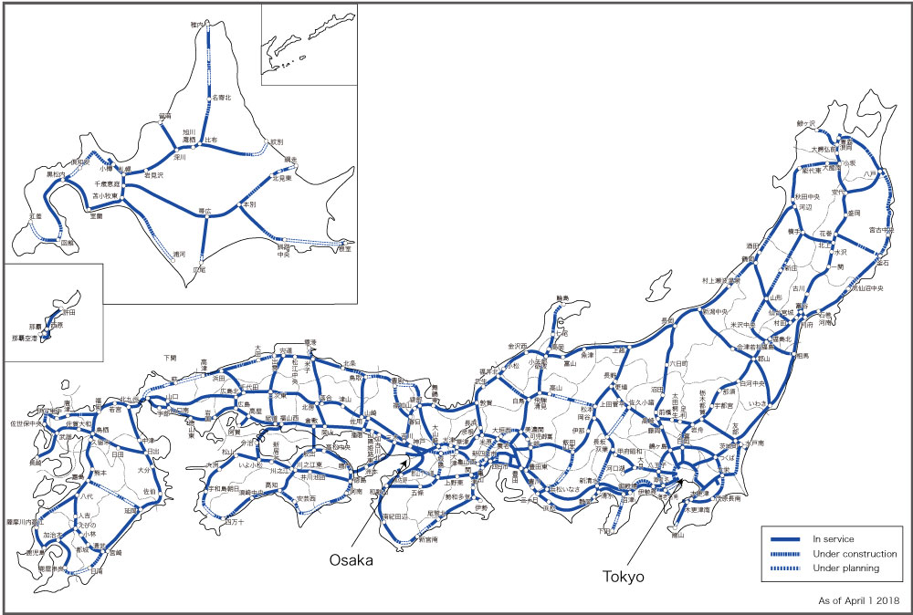
In 1987, the National Development Arterial Expressway Construction Law was revised, where the Japanese government approved expanding the expressway network (through the Fourth Comprehensive National Development Plan) to 11,520 km together with 2,480 km of access-controlled national highways, where a map of this system as of April 2018 may be found at https://www.mlit.go.jp/road/road_e/images_n/policies/p1_1_1.jpg. With the revision of the Law came inefficiencies, welfare loss and a mounting debt, because the newly planned routes of 3,920 km incurred high construction costs and only low projected traffic volumes to provide revenue (Kimura and Maeda 2005: 9). The tolls were revised in 1989 and again in 1994. The redemption principle was re-organised by extending the redemption period, initially from 30 years to 40 years, and, eventually, to 50 years.
Prime Minister Koizumi Junchirō established the Committee for Promoting Privatization of Four Highway-related Public Corporations that were responsible for the construction and management of highways in Japan: the JHPC (1956); the Metropolitan Expressway Public Corporation (1959); the Hanshin Expressway Public Corporation (1962); and the Honshū—Shikōkū Bridge Authority (1970). In December 2002, the committee’s final opinion report recommended an organisational reform based on the principle of vertical unbundling, where highway service companies would provide services to an infrastructure holding organisation.
The Privatization Bill was passed in the Diet in June 2004. Privatisation of highways was based on the following acts: the Expressway Company Law; the Japan Expressway Holding and Debt Repayment Agency Law (JEHDRA); the Law Regarding the Development of Highway-Related Laws in Connection with the Privatization of the Japan Highway Public Corporation; and the Act for Enforcement of Acts Related to Privatization of the Japan Highway Public Corporation Road Bureau, Ministry of Land Infrastructure (Road Bureau, Ministry of Land, Infrastructure, Transport and Tourism, 2018: 7).
There are two key elements to the Privatization Bill (Mizutani and Uranishi, 2006). First, six specific joint-stock highway corporations (one-third government owned) would have the power to veto highway construction, although the Panel on Infrastructure Development would make the final decision on whether to proceed or not. Secondly, an independent administrative agency, the Japan Expressway Holding and Debt Repayment Agency (JEHDRA) was established to function as an asset-holding and debt-servicing public organisation with a sunset clause. The JEHDRA took over both the assets and the debts held by the former highway-related public corporations, and then leased the assets to the six expressway companies that would then collect tolls from each expressway and pay back the JEHDRA with the agreed lease fee such that once the repayment is completed by 2050, the agency would be dissolved.
With a recognition of a declining national population, and that land transport networks were largely mature, road administration was placed within a new “super” ministry, the Ministry of Land, Infrastructure, Transport and Tourism (MLIT). It was established as part of administrative reforms on 6 January 2001 with the merging of the Ministry of Transport, the Ministry of Construction, the National Land Agency and the Hokkaidō Development Agency. Of all Ministries in Japan, it has the greatest number of employees. It is in charge of the comprehensive and systematic use of national land, development and conservation, infrastructure development, implementation of transport policies and maritime safety and security. In addition to its policy functions, the Ministry contains transport departments for ports and harbours, maritime, roads, railways and civil aviation.
Together with regional public corporations, NPOs and other citizens’ groups, the Japanese government aims to enhance the administrative management of roads. In order to achieve more effective, efficient and transparent road administration, Japan has promoted a result-oriented administrative management for roads (Road Bureau, Ministry of Land, Infrastructure, Transport and Tourism, 2018: 19).
Today, bicycles are ubiquitous in urban areas and country towns and villages. Growing steadily from a base of about 3 million bicycles in 1920 (Koike, 1991: Figure 1, p. 41), Koike points out that the bicycle ownership rate has always been higher than the car ownership rate and laments that, in 1988, the length of exclusive bicycle paths represented only 0.13 per cent of the road network. The revised Road Traffic Act of 1981 permitted bicycles to share the sidewalk with pedestrians. Writing in the early 1990s, Koike (1991: 44) suggests that the bicycle “has not been accepted as a legitimate mode of transport in the Japanese transport hierarchy”.
It was not until December 2016 that the Bicycle Use Promotion Act was adopted with the establishment of the “Bicycle Use Promotion Headquarters” within the Ministry of Land, Infrastructure, Transport and Tourism (Road Bureau, Ministry of Land, Infrastructure, Transport and Tourism, 2018: 25). In 2020, there were some 69.1 million bicycles registered (the registration fee is approximately 500 yen) in Japan.
The principles underpinning this institutional interest in bicycles as a transport mode are that they contribute to the reductions in car dependency, in traffic congestion and in emissions. Bicycles improve mobility in a time of disaster and have health benefits. The main responsibility of the national government is to promote bicycle use in an integrated and systematic manner. The role of municipal governments is to implement realistic measures through a proper role sharing with the National Government. Public transport operators should aim for a symbiotic relationship between bicycle and public transport. Citizens are urged to support various bicycle-use measures implemented by the National and municipal governments (Road Bureau, Ministry of Land, Infrastructure, Transport and Tourism, 2018: 25).
Conclusions
A ‘national’ institution for roads in Japan has existed from ancient times, and, on occasion, policies have been copied from overseas experience. In the first place, the Yamato kings and queens learnt from the Chinese about road administration, especially the importance of locating post stations and planting shade trees. Security on the roads—initially on the borders with indigenous tribes, and, later, for internal control—was facilitated by erecting barriers that became a long-standing institution associated with the road network.
Barriers on roads were first established as a government instrument in the Yamato State then expanded into a system of government-controlled barrier stations established after the Taika Reform of 645 that were only abolished in the later part of the 19th century. They were essential components of road administration during the Edō period when Tokugawa Ieyasu designated five radial highways from Edō and used them to ensure firearms were not smuggled into the capital nor the wives of daimyō held captive smuggled out of Edō, and that the movement of ordinary people was controlled through the issue of travel permits.
The government controlled post stations had an equally long history. Their prime purpose was to provide horses and porters to relay messages and packages. During the Edō period, accommodation and food services were added primarily for the daimyō and their retainers who travelled as part of the system of alternate year attendance in Edō. The costs of the operations of post stations were born by the daimyō domains and obligations on local villages. In addition, the bakufu levied taxes on each post station, including revenue derived from prostitution.
The first formal recognition of an institution to manage roads can be traced to the establishment in 1659 by Tokugawa Ietsuna of a Magistrate of Road Affairs. The role was the overseeing of the upkeep of road infrastructure, the processing of petitions and communication policy with the bakufu intendants who reported on all matters pertinent to roads under their jurisdiction. Bakufu officials periodically checked to ensure approved road and bridge maintenance had been completed satisfactorily to orders at a cost borne by local communities.
The modern era brought about the modernisation of government along Western lines. The Home Ministry was established in November 1873 (abolished in December 1947) and public works was included within this portfolio. However, the Japanese national government did not see the importance of investment in roads given other priorities and it was not until the post-Pacific War, and the modern democratic era, that highway administration mirrored countries such as the U.S.A.
The American, Dr Ralph Watkins, was invited by the Japanese Government to consider the economic feasibility of the Nagoya—Kōbe Meishin Expressway. The Watkins Report triggered a flurry of highway legislation providing for national expressways, national toll roads, revised funding arrangements (government bonds, grants to prefectures) and metropolitan expressways. For example, in 1956, the Japan Highway Public Corporation was established and took over responsibility from the Ministry of Construction to construct the national toll highway network and to collect road user tolls.
By the beginning of the 21st century, land transport networks were largely mature and road administration was placed within a new “super” ministry: the Ministry of Land, Infrastructure, Transport and Tourism (MLIT). Administrative reforms of 6 January 2001 merged the Ministry of Transport, the Ministry of Construction, the National Land Agency and the Hokkaidō Development Agency. The Ministry is in charge of the comprehensive and systematic use of national land, development and conservation, infrastructure development, implementation of transport policies and maritime safety and security.
Prime Minister Kozumi Junichiro (1942–) established a committee on highway privatisation that recommended, in December 2002, organisational reform based on the principle of vertical unbundling, where highway service companies would provide services to an infrastructure holding organisation. The Privatization Bill was passed in the Diet in June 2004. Six joint-stock highway corporations (one-third government owned) were created and an independent administrative agency (Japan Expressway Holding and Debt Repayment Agency) was established to function as an asset-holding and debt-servicing public organisation.
Government policies direct the services these authorities deliver, including budget allocations for road planning, construction and maintenance. The regulatory framework for the highway sector determines the rules that affect the everyday actions and decisions of businesses and citizens when going about their work, personal business or leisure activities. Therefore, the regulatory framework is a critical determinant of how the government delivers its services effectively (Australia, NSW Regulatory Policy Framework Review Panel, 2017). The functions of national and prefecture road authorities and the responsibilities of local government—and the way they are structured—are not static over time but have evolved with regulatory and policy reform. This will continue to be a challenge for Japan as discussed in the final chapter to this book.
References
AllAboutJapan (2017) “Hakone Sekisho: Historical Checkpoint”, https://allabout-japan.com/en/article/6114/
Australia, NSW Regulatory Policy Framework Review Panel (2017) NSW Regulatory Policy Framework: Independent Review—Final Report. NSW Treasury, Sydney, https://www.treasury.nsw.gov.au/sites/default/files/2018–02/Independent%20Review%20of%20the%20NSW%20Regulatory%20Policy%20Framework%20final%20report.pdf
Bamhill, D. L. (2004) Bashō’s Haiku: Selected Poems of Matsuo Bashō, translated and with an Introduction by David Landis Bamhill. University of New York Press, Albany, New York.
Barnes, G. L. (2019) “The Jōmon-Yayoi Transition in Eastern Japan: Enquiries from the Kantō Region”, Japanese Journal of Archaeology, 7, 33–84.
Black, J. A., and P. J. Rimmer (1981) “Japanese Highway Planning: A Western Interpretation”, Transportation, 11, 29–49.
Bornoff, N. (1991) Pink Samurai: Love, Marriage & Sex in Contemporary Japan. Pocket Books, New York.
Chamberlain, B. H. (1981) The Kojiki: Records of Ancient Matters, translated into English in 1906 with annotations in the Second Edition by W. G. Aston. Tuttle Publishing, Tokyo.
David, D. (2014) “The Japanese Experience with Highway Development”, Journal of Infrastructure Development, 6 (1), 17–42.
Japan Heritage Portal Site (2019) “Takenouchi Kaido /Yokooji: Japan’s Oldest National Highway with a History of 1400 Years—Story 44”, https://japan-heritage.bunka.go.jp/en/stories/story044/
Japan, Nihon Doro Kodan (1957) Evaluation of the Kobe-Nagoya Expressway Survey: A study of the Report Submitted to the Japanese Government by a Group of Experts Headed by Ralph J. Watkins. Nihon Doro Kodan, Tokyo.
Kapur, D., J. P. Lewis and R. Webb (eds) (1997) The World Bank: Its First Half Century, Volume 2: Perspectives. Brookings Institute Press, Washington D. C.
Kimura, Fukunari and Mitsuhiro Maeda (2005) “Transport Infrastructure Development in Japan and Korea: Drawing Lessons for the Philippines -Summary”, https://citeseerx.ist.psu.edu/viewdoc/download?doi=10.1.1.691.3815&rep=rep1&type=pdf
Kodansha (1993) Japan: An Illustrated Encyclopedia. Bunkyo-ku, Tokyo.
Koike, Hirotaka (1991) “Current Issues and Problems of Bicycle Transport in Japan”, Transportation Research Record, 1294, 40–46.
Matsuda, W. (2019) “Poets on the Periphery: Kūkai’s Vision of Frontier Governance”, Journal of Asian Humanities at Kyushu University (JAH-Q), 4, 21–37.
Ministry of Land, Infrastructure, Transport and Tourism (2015) Priority Plan for Infrastructure Development: The Cabinet Decision on September 18, 2015. Ministry of Land, Infrastructure, Transport and Tourism, Tokyo.
Ministry of Land, Infrastructure, Transport and Tourism (2021) “History: Age of Modernisation”, https://www.mlit.go.jp/road/road_e/q1_history_2.html
Mizutani, Fumitoshi and Shuji Uranishi (2006) “Privatization of the Japan Highway Public Corporation: Policy Assessment”, European Regional Science Association Conference Papers, Volume 6, 229, https://citeseerx.ist.psu.edu/viewdoc/download?doi=10.1.1.738.6905&rep=rep1&type=pdf
Moriya, Katsuhisa, translated by T. Ronald (1990) “Urban Networks and Information Networks”, in Chie Nakane and Shinzaburō Ōishi (eds) (1990) Tokugawa Japan: The Social and Economic Antecedents of Modern Japan. Tokyo University Press, Tokyo, 97–114.
Moulton, H.G. with the collaboration of Junichi Ko (1931) Japan: An Economic and Financial Appraisal. The Brookings Institute, Washington, D.C.
Muto, Hiromi (2008) Doro Gyosei [Road Administration]. Tokyo University Press, Tokyo.
Ohkura, Takehiko and Hiroshi Shimbo (1978) “The Tokugawa Monetary Policy in the Eighteenth and Nineteenth Centuries”, Explorations in Economic History, 15 (1), 101–124.
Ong, Daina (n.d.) “Takenouchi Kaido, the Oldest Recorded Road in Japan”, https://www.japan-guide.com/ad/takenouchikaido/
Redesdale, A. B. F. M., Lord (1915) Memoirs, 2 Volumes. Hutchinson & Co., London.
Road Bureau, Ministry of Land, Infrastructure, Transport and Tourism (2018) 2018 Roads in Japan. Ministry of Land, Infrastructure, Transport and Tourism, Tokyo, http://www.mlit.go.jp/road/road_e/pdf/ROAD2018web.pdf
Sato, Tetsuji, Jun Nakamura, and Kenta Shimizu (2011) “Comprehensive Evaluation Index for Redevelopments of Historical Streets in Japanese Koedo Cities”, Proceedings of the Eastern Asia Society for Transportation Studies, 8, n.p.
Sheldon, C. D. (1983) Merchants and Society in Tokugawa Japan, Cambridge University Press, Cambridge.
Shibayama, Takeru (2017) “Japan’s Transport Planning at National Level, Natural Disasters, and their Interplays”, European Transport Research Review, 9 (44), https://doi.org/10.1007/s12544–017–0255–7
Steele, M. W. (2016) “Roads, Bridges, Tunnels and Empire: Highway Construction and the Great East Asian Co-Prosperity Plan”, Asian Cultural Studies, 87–101,
Suzuki, Shousei (n.d.) “The Ise Pilgrimage: A ‘Must’ Once in a Lifetime”, https://web.archive.org/web/20180421093301/http://web-japan.org/tokyo/know/pilgrimage/ise.html [accessed 2 July 2019].
Takagi, Hisashi (2018) “Recent Studies of Bronze Coin Integration at the Beginning of Early-modern Japan,” 安田女子大学紀要, 46, 11–18.
Takebe, Kenichi (2015) 道路の日本史—古代駅道路から高速道路へ [History of Roads in Japan: From Ancient Station Roads to Highways]. Chuko Shinsho, Tokyo.
The Association for Japanese History and Travel (2018) “Past and Present of Hakone Barrier Station”, 14 July 2018, http://japan-history-travel.net/?p=5743
Traganou, J. (2004) The Tokaido Road: Traveling and Representation in Edo and Meiji Japan. Routledge Curzon, New York.
Tyler, R. (2012) The Tale of the Heike, translated by Royall Tyler. Viking Penguin, London.
U.S. Bureau of Public Roads (1950) Highway Capacity Manual, First Edition. U.S. Bureau of Public Roads and Highway Research Board, Washington, D.C.
Vaporis, C. N. (1994) Breaking Barriers: Travel and the State in Early Modern Japan. Harvard University Press, Cambridge, Mass.
Vaporis, C. N. (1997) “To Edo and Back: Alternate Attendance and Japanese Culture in the Early Modern Period”, The Journal of Japanese Studies, 23 (1), 25–67.
World Engineering Congress, Publications Committee (1929) Industrial Japan: A Collection of Papers by Specialists on Various Branches of Industry in Japan. International Publishing and Printing Company, Tokyo.
1 A haiku of 5–7–5 syllables translates as: “this road—/ with no one on it / autumn dusk”
2 A stanza by Kūkai (Matsuda, 2019: 27), written around 815 A.D., describes the conflicts between the aboriginal Emishi and Japanese colonists:
“They are like the man-eating Raksasa devils, they are not human
They frequently come to our settlements,
Where countless people and oxen are massacred and eaten
Their galloping horses and brandished swords are
like flashes of lightening”
3 Following the death of Emperor Tenji (626–672) there was a war of succession where Prince Ōama, Tenji’s younger brother, supported by local rulers who resented the Taika Reforms of 645, defeated the nominated heir, Prince Ōtomo.
4 The contribution from assisting villages for horses and porters increased from about 3 per cent and 31 per cent, respectively, in 1819 to about 18 per cent and 83 per cent in 1861 using the post station of Shinagawa as an example (Vaporis, 1994: 83).
5 In 2013, the number of visitors to Ise Shrine passed 10 million—the first time since 1896 when counts were first taken (Japan Times, 20 December 2013).
6 The International Bank for Reconstruction and Development (World Bank) has lent funds to numerous JHPC projects since the 1960s: all repayments were made by 1990.