
8. Urban Planning Institutions and the Integration of Land Use and Transport
© John Andrew Black, CC BY-NC 4.0 https://doi.org/10.11647/OBP.0281.08
Transport planning and land-use planning are not separate activities but should be performed by a single department as an ongoing process.
Sharp, 1970
Introduction
In previous chapters, institutional and organisational transformations were examined from a perspective of the historical delivery of infrastructure and services for ports, canals, roads, railways and airports. In contrast, this chapter is about institutions and organisations that plan for future transport together with their adjacent land uses. For long-term future transport infrastructure development, there is a need to consider land use and transport as an “integrated planning process” (Buchanan, 1963; Sharp, 1970). Therefore, this chapter explores some examples of how Japan has responded to this challenge of a comprehensive approach to land-use and transport developments and the planning institutions that have guided such developments.
Watanabe (1980: 63) points out the importance of developing planning systems that are based on specific socio-historical conditions and cites Japan as important case studies, where, in a short space of time, feudal castle towns were supplanted by steel and skyscrapers. From ancient times, Japanese rulers had knowledge transmitted from China as to the main principles in the layout of capital cities (Hein, 2016), and, during the early Edō period, Tokugawa Ieyasu drew on geomancy in developing his new castle town with its distinctive arrangement of functional areas, largely to control the different classes in society (Hamp, 2019: 2–4). However, it was not until the modern period following the Meiji Restoration that government institutions to control, and direct, urban development were established based on overseas experiences.
The early institutional initiatives were confined to the new capital of Tōkyō. Institutional arrangements had also to cope with the reconstruction of cities, especially after the 1923 Kantō Earthquake (Hammer, 2011), and after the bombing of most major cities during the Second World War, such as Tōkyō (see Hein, 2016, Fig. 7, p. 9). Two levels of the Japanese planning system are described: at the metropolitan level with Tōkyō as an example because it provides the genesis of the contemporary Japanese land-use planning system; and the national system that subsequently evolved in the modern democratic period following the end of the Pacific War.
Within these planning frameworks, there are three topics that are examined in detail—which all would be familiar today to urban planners across many parts of the world: the land adjustment mechanism and value capture; transport-oriented development; and ‘smart cities’. One of the most successful policies associated with the post-war reconstruction of Japanese cities is the land-readjustment program that has been promoted in many Asian cities by Japanese consultants (Archer, 2000). Murakami (2011: 1) points out that “Tokyo is one of the most advanced cases of the transit-oriented megalopolis model” and he estimates the monetary potential to finance new railways through the value capture mechanism. Transit-oriented development is illustrated along with the Japanese new town program.
The Japanese Government has also been proactive on what might a future society and its urban form and function take (James, 1990). For example, the “multi-function polis (MFP)” was an urban development concept developed by the Ministry of International Trade and Industry (MITI) and explored for implementation in Australia (Australian and Japanese Governments Joint Steering Committee to Oversee a Major Study Investigating the Feasibility of the Multifunction Polis Concept, 1990; Smith et al., 1993; Hamnett, 1997). More recently, Japanese Government policies to promote ‘smart cities’ have been initiatives in many countries since the early 21st century and specific Japanese examples are described in this chapter.
Planning Tōkyō in the Modern Period
The purpose of this section is not to repeat the history of urban planning in Tōkyō as there exists a substantial literature in English on its planning (for example, Hall, 1966; Cybriwsky, 1998; Hein, 2010). Also, the history of planning legislation in Ōsaka-Kōbe is described by Perez (et al., 2019). The Meiji government took the initiative to restructure Edō from a medieval castle town into a modern capital city. This “modernisation” of Tōkyō was in conformance with a “Western image” as the prime objective (Funo, 2005: 246). It is important to note that, before the Meiji Restoration, the spatial layout of Edō was arranged by class: ordinary people lived to the east of the castle primarily on the banks of the Sumida River and Edō Bay.
Commercial Edō was designed for the traffic movements on water and on foot. Although there was some reliance on forms of land transport, such as ox-drawn carriages, the conveyance of goods into and out of Edō depended on complex network of canals (Hamp, 2019: 3). Despite these logistical efficiencies, writings by Westerners were scathing of the dismal and dilapidated state of many buildings in the new capital (Hein, 2016: 3), for example, around Nihonbashi (The Far East, 1872). Therefore, the Meiji government focused on adapting the new capital Tōkyō to worldwide development standards.
With regard to urban planning, Coaldrake (cited by Hamp, 2019: 6) states:
At the beginning of the new era one of the most urgent tasks facing the Meiji leaders [...] was the construction of a new built environment for the conduct of the affairs of state and the development of modern industry, commerce and education. The ‘accepted practices of the world’ meant the creation of Western-style urban plans and buildings, particularly for the newly designated capital city of Tōkyō
The Emperor Meiji commissioned the 50-person Iwakura Mission (led by statesman Iwakura Tomomi, 1825–1883) who travelled to North America and Europe in 1871–1873 (Kodansha, 1993: 640–641). In a friendship mission, they sought to promote the “civilisation and cultural renewal” of Japan in accordance with Western models of development, that included urban planning practices (Hamp, 2019: 6).
The risk of fire was well understood in Edō times with unambiguous Tokugawa Government directives on managing the outbreak of fires. There were 91 fires that burned 15 blocks or more over a period of 234 years (Sand, 2017: 88). After the Great Ginza Fire of 1872, the Meiji government issued a statement advocating the building of a fireproof city, and Shin-ryōgae-chō (Ginza) was reborn as a Westernised rengagai or ‘bricktown’ (Tokyo Ginza Official, 2021). The Ginza Brick Quarters Project (1872–1877) was promoted by the Minister of Finance, Ōkuma Shigenobu, and was symbolic of modernisation launched to refashion the entire district with European highlights fashioned in red brick buildings. The English architects—the Waters Brothers—were invited to prepare plans for the area. A decade later, 2,855 buildings had been completed in a Georgian style with streetscape of maples, willows and gaslights (Sorensen, 2002).
The origin of city planning legislation in Japan—the Tōkyō Town Planning Ordinance—was formulated in 1888. Hibiya Park, Ueno Park, and the road that runs along the Imperial Palace moat, are physical legacies of that time. The Tōkyō Town Planning Ordinance was superseded by the City Planning Act of 1919, which, in turn, was short lived because of the 1923 Great Kantō Earthquake. On 1 September 1923, a magnitude 7.9 earthquake struck the Kantō region. Approximately 3,465 hectares (44 per cent of the Tōkyō’s area) was subsequently destroyed by the fires that were triggered by the earthquake. About three-quarters of households were affected by the disaster.
The following day, the Cabinet of Prime Minister Yamamoto Gonbe established the Bureau for Reconstruction of the Imperial Capital—an institution under the direct control of the Prime Minister. The Minister of Home Affairs and former Mayor of Tōkyō, Goto Shinpei, was appointed as President of the Bureau for Reconstruction of the Imperial Capital. He led the planning and reconstruction of the city, incorporating modern planning methods. The original budget request to implement the plan was 1.5 billion yen but this was cut by about a third to 468 million yen (Metro Tokyo, 2021). The main mechanism for government intervention was land readjustment (described in more detail in a later section) to rezone land over significant parts of the devastated areas.
Both the national and the Tōkyō metropolitan governments have continuously been involved in trying to regulate urban growth and renewal with their planning institutions evolving with time. From 5 April 1919 and 15 July 2018, a total of 235 Tōkyō City planning laws and regulations, and numerous Cabinet orders, were issued so what follows by necessity is a cursory examination of the interactions between governments, the private sector and the broader community of interested stakeholders in the processes of urban development in the modern democratic era. The details of these laws and regulations are listed in a document that is regularly updated on the Metro Tokyo, and the reader can readily access them (http://www.toshiseibi.metro.tokyo.jp/eng/pdf/index_06.pdf?1503).
Planning Tōkyō in the Modern Democratic Period
With changing socio-economic circumstances in the chaotic period after 1945, the Comprehensive National Land Development Act of 1950 was promulgated by the Japanese Government. The first substantial step towards post-war reconstruction was made under the Tōkyō Special City Plan (e.g. land readjustment for reconstruction). By the beginning of 2013, land readjustment projects had been completed in 593 areas (approximately 21,312 hectares) and they are ongoing in 23 areas (approximately 520 hectares) in the Tōkyō ward areas, and in 36 areas (approximately 1,055 hectares) in the Tama district (Tokyo Metropolitan Government, n.d.: 74). In June 1950, the Capital Construction Law was established as a national project to construct Tōkyō as a national showcase. Given the high population growth and the rapid suburbanisation, this law proved ineffective in controlling urban development in the Tōkyō region.
As a result, the National Capital Region Development Act of April 1956 was introduced to control development over the greater metropolitan region.1 Under this act, the Tōkyō Metropolitan Government promoted an all-out revision of urban plans: parks and green spaces in 1957; expressways in 1959; and high-speed railways in 1962. The partial revision of the Building Standards Act of May 1950 in January 1963 resulted in zoning to secure open spaces, to redress the imbalance between the over-concentrated population and urban facilities. The formulation of these land-use plans at the ward level opened up new avenues for skyscraper development. Green spaces that had been designated under earlier policies gave way to land readjustment projects enabling further comprehensive, high-rise residential development.
The Second and Third National regional capital plans (1976 and 1986) both addressed the formulation of policies for “suburban development areas” around the existing built-up areas of Tōkyō in order to develop balanced and well-designed hierarchical urban centres and to preserve some green areas but on a much smaller scale than before. Notably, the plans were not only limited to industrial and satellite cities but also to academic, recreational and cultural facilities.
This transformation from a mono-centric city to a poly-centric employment structure was anticipated by Lewis Mumford (1895–1990) who made substantial contributions to the history of technology, the history of cities and urban planning practice. Writing in 1937, he predicted the emergence of a new form of the metropolis called the “poly-nucleated city”, suggesting that even without planning and “intelligent public control” the de-centralisation of urban functions would accelerate. However, over the years, despite the substantial efforts to promote a multi-nucleus urban pattern, Tōkyō continued to preserve its strong centralised structure (Alpkokin et al., 2007a).
The Fourth and Fifth Plans firmly designated “business core cities”2 defined as the high-density core settlements within the Tōkyō central area; and “bases for large cooperation” defined as the large centres outside the Tōkyō central area. Urban re-generation plans have also been applied for non-core city development and one good example is the re-development of Roppongi, where a multi-use, 54-floor tower has been constructed near subway rail stations. The Plans state their primary aim as polycentric spatial re-structuring with a circular development of stronger urban nodes outside the Tōkyō central area to ensure self-reliant regions, to strengthen the regional network and co-operation, and also to mitigate the stress on the central area.
Despite these top-down national and metropolitan government policy interventions, the high economic growth from the mid-1950s onwards caused a further intensification of population and industry in Tōkyō resulting in a confused mixture of land uses and further suburban sprawl. A new City Planning Act was promulgated in June 1968 and put into force a year later as a strategic land use planning tool to prevent housing shortages, to reduce long journey-to-work commuting travel and to tackle environmental pollution. Significantly, there was a devolution of powers to prefectural governors and municipalities to ensure greater citizen participation in the land-use development process (Tōkyō Metropolitan Government, n.d.: 3–4).
In 1980, the “district planning system” was established where municipalities—the local governments that are closest to residents—were given decision-making powers. In June 2013, the City Planning Act was partially revised, in association with the enforcement of the Decentralization Law (the third package bill), that abolished the requirement to send a copy of relevant documents to the Minister of Land, Infrastructure, Transport and Tourism following a decision on city planning.
Railway improvements and linking land-use development has a long history in Japan. For example, even before the 1940s, when the railway enterprises invested in new rail lines, they also owned and developed the land parcels around the major stations. Since the 1960s, Tōkyō has developed its rail network (Morichi et al., 2001: 3), not only its central subway system but also suburban railways connecting the centres designated in the land-use plans. In the 1970s and onwards, new rail lines have connected the business core cities and the centre of Tōkyō (the Musashino-line in 1973; the Hokuso-line in 1979; and the Tsukuba express connecting Tsukuba and Akihabara in 2005).
Another important feature of railway development is that local councils responsible for transport policy assist in the development the railways in their metropolitan areas; they give recommendations about certain construction and upgrading projects. Only if listed in the Council’s report, can construction commence on new railway lines. The ninth report by the Tōkyō Metropolitan Council in 1966 was the first document to address transit-focused development.
Figure 7 identifies the main policy areas located within the Tōkyō Capital Region. The existing urban area of Tōkyō is indicated in light brown. The lightest of the shading shows the suburban development areas. The areas shown in black are designated for green conservation. The dark brown areas are the nodes identified for new urban development such as Utsunomiya (connected to central Tōkyō Station by high-speed rail) and Kōfu (a station on the Chuō maglev Shinkansen linking Shinagawa Station). The extensive rail and subway networks in Tōkyō facilitate public transport connections from all of the development locations in Figure 7 into core activity areas, as can be demonstrated by consulting the interactive rail service MiniTokyo3D website (https://minitokyo3d.com).
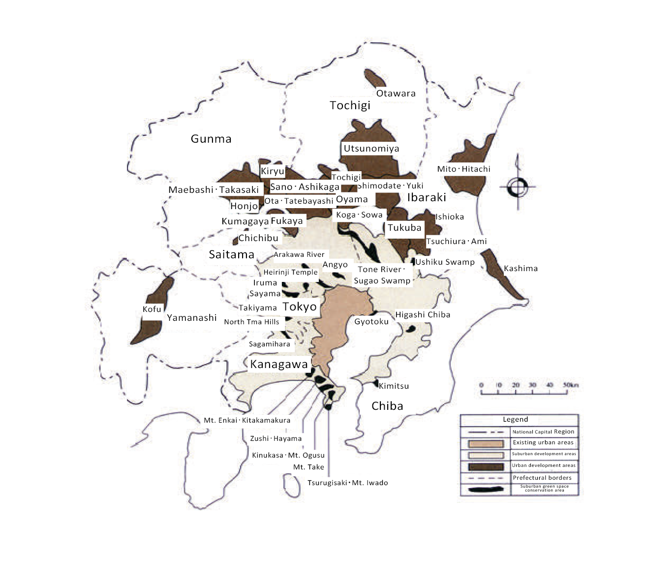
Figure 7. Map of the Tōkyō Capital Region Policy Areas.
Source: Tokyo Metropolitan Government, n.d., Figure 2–4, p. 12, http://www.toshiseibi.metro.tokyo.jp/eng/pdf/index_02.pdf?1503.
Institution for National Land-Use Planning
At the national level, the Japanese Government has, in theory, the necessary institutional arrangement to achieve integrated approaches, where all modes of transport and land development are located in one ministry. The most recent organisational structure (as of 2015) for the Ministry of Land, Infrastructure, Transport and Tourism (MLIT) is found at https://www.mlit.go.jp/common/000026153.pdf. In addition to mode specific bureaux covering maritime and ports, waterways, roads, railways and civil aviation, there is also a bureau devoted to spatial planning and regional policy to complement a top-down approach to integrated planning. There is a hierarchy of land-use plans that flows from the top downwards from the national level, to the regional level, to the prefectural level and finally to the municipal level as illustrated by the Tokyo Metropolitan Government (n.d.: 7).
Land Readjustment Program
Land readjustment is such an important component in understanding the processes of urban development in major Japanese cities that a description of its institutional arrangements is worth outlining. Category 1 Urban Redevelopment Projects are executed by the method called “right conversion”. The right conversion is a method of equivalent exchange between rights (original assets), such as the ownership, lease right and rented house right of land and building prior to the project execution and a right to land and building after the project execution (resultant assets = “entitled” floors). Amongst the building floors that are constructed by the project (including pieces of land corresponding to the floors), floors that exceed “entitled” floors are called reserved floors that are sold to obtain the funds to cover the costs of launching a project. Those people in the affected area who do not accept the “right conversion” may make a request compensation from the project executor to move out and relocate somewhere else (Tokyo Metropolitan Government, n.d., Figure 3–9, p. 74).
The land readjustment program usually functions through the collaborative activities of civil society, although sometimes the program is in partnership with local government. A private citizen—a landowner, or a land lease right holder or a group of them—within the designated project area may become an executor or executors by preparing a constitution and a project plan. The unanimous consent of right holders within the area are first obtained and then permission from the prefectural governor is obtained to proceed for implementation of the development. Those other than right holders within the area may also become executors by obtaining unanimous consent of the right holders.
To explain how private organisations can be involved in the urban development process, redevelopment associations of landowners, or land-lease right holders, are formed as follows. If the founders are at least five in number within the project area, and they have prepared the articles of incorporation and a project plan with the consent of at least a two-thirds majority of members, then they may become executors by obtaining the authorisation from the prefectural governor to establish a partnership that becomes the urban redevelopment association. Specified architectural consultants carry out the project in cooperation with the executors through their provision of funding or design technology.
A more commercial organisation is formed in the following way. Business corporations, or limited liability companies, that share at least two-thirds of the land parcels within the project area and hold more than half of voting rights, prepare the articles of incorporation together with a project plan. Once they obtain consent of a two-thirds majority of the landowners and the land lease right holders within the project area, and if the right area of consenters constitutes two thirds or more of the total right area, then they become executors of a development by obtaining authorisation from the prefectural governor.
There is a provision in the program that the Tōkyō Metropolitan Government and municipalities may become executors in land readjustment schemes by obtaining project approval from the Minister of the Ministry of Land, Infrastructure, Transport and Tourism and the prefecture governor. Also, the Urban Renaissance Agency and the Tōkyō Metropolitan Housing Supply Corporation may become executors by obtaining project approval from the Minister of Land, Infrastructure, Transport and Tourism.
Land Readjustment Mechanism
The mechanism of the land readjustment program and local government planning is illustrated in Figure 8. This mechanism has proved to be a highly successful policy for the redevelopment of station precincts. It has allowed existing landowners to share in some of the profits that arise from re-zoning to higher densities, for developers to consolidate lots to allow imaginative higher density buildings to be erected and to return land for public purposes around railway station pedestrian access points. This provision in the planning act is illustrated with a case study of Shibuya in Tōkyō that reveals the complexity of such an integrated urban redevelopment project.
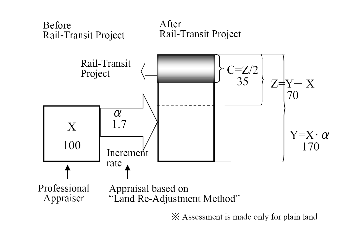
Figure 8. Mechanism of the Land Re-adjustment Program in Japan.
Source: Professor Kazuaki Miyamoto, pers. comm.
Shibuya Station in Tōkyō has posed difficulties for passengers in finding how to change trains due to its complicated structure that was formed through its repeated extension and reconstruction since the Taishō era. In addition, it has suffered problems in terms of safety and convenience, such as a station square crowded with pedestrians and buses. In order to resolve these problems, a plan promoted drastic improvement of safety and convenience by reorganising and improving the station square plaza and re-developing its adjacent areas in an integrated manner together with railway improvements.
The conceptual vision was a strengthening of the international competitiveness of the locality by introducing cultural, exchange and information-transmission functions, advanced business functions (such as creative content industries, and industrial development functions). The Shibuya Station improvement project involved public-private cooperation, based on two documents: the development policy for Special Urban Renaissance Urgent Development Areas; and the Policy on Infrastructure Development in the Shibuya Station Central Area. The project timeline from 2007 to 2013 involved land readjustment projects, railway improvement projects, a national road project under the direction of the Ministry of Land, Infrastructure, Transport and Tourism is summarised in Table 26.
Table 26. Land Readjustment and the Timeline for the Recent Redevelopment of Shibuya Station, 2007–2013.Source: Author.
|
Date |
Activity |
|
September 2007 |
Formulation of the 2007 Town Development Guidelines for Shibuya Station Central Area |
|
June 2008 |
Opening of the Tōkyō Metro Fukutoshin Line; formulation of the Policy on Infrastructure Development in Shibuya Station Block |
|
June 2009 |
City planning decisions on projects for roads, traffic square, land readjustment, etc. |
|
March 2011 |
Formulation of the 2010 Town Development Guidelines for Shibuya Station Central Area |
|
October 2012 |
Formulation of the Policy on Infrastructure Development in Shibuya Station Central Area |
|
March 2013 |
Underground installation of the Tōkyū Tōyoko Line; Start of its mutual direct operation with the Fukutoshin Line |
|
June 2013 |
City planning decisions on the special urban renaissance districts (Shibuya Station area, Shibuya 3, Chōme 21 area) |
“Transit-Oriented Development”
The phrase “transit-oriented development” (TOD) is a give-away to its American origin. Before describing, with examples, the Japanese characteristics of TOD, the U.S. concept is first explained. In the international Western literature, transit-oriented development is a concept where a rail, bus, or ferry public transport can anchor a more environmentally and socially responsible urban form to achieve more sustainable urban development outcomes. For example, in the U.S.A. transit-oriented development has been promulgated by leading architects and planners, with support from the development industry (Calthorpe Associates, 1990; Calthorpe, 1993), as part of the ‘new urbanism’ (which in itself is an American term).
Transit-oriented development “is viewed by many as a promising tool for curbing sprawl and the automobile dependence it spawns” (Cervero et al., 2004: 3). A synthesis of the literature suggests that the U.S. transit-oriented developments include the following ten characteristics.
- Development that lies within a five-minute walk of the transit stop, or about a quarter of a mile from stop to edge. For major stations offering access to frequent high-speed service this pedestrian catchment area may be extended outwards to a 10-minute walk.
- A balanced mix of uses of residential and commercial space located adjacent to a major transit stop with a 24-hour ridership.
- A place-based zoning code at, or near, transit stops that generates buildings that shape and define memorable streets, squares and plazas, while allowing uses to change easily over time.
- A built form with public transit included that presents an average block perimeter limited to no more than 1,350 feet (411 metres). This generates a fine-grained network of streets, dispersing traffic and allowing for the creation of quiet and intimate thoroughfares.
- Minimum parking requirements are abolished since the goal is to reduce private motor vehicles and make them more, and not less, convenient for pedestrians and users of public transport.
- Maximum parking requirements are instituted as a counter to the usual notion of providing parking for every peak demand. For every 1,000 workers, no more than 500 spaces and as few as 10 spaces are provided.
- Parking costs in TOD are “unbundled,” and full market rates are charged for all parking spaces to promote less car use.
- Major stops provide bike stations, offering free attended bicycle parking, repairs and rentals. At minor stops, secure and fully enclosed bicycle parking is provided.
- Transit service is fast, frequent, reliable and comfortable, with headways of 15 minutes, or less. Roadway space is allocated to different users and traffic signals timed primarily for the convenience of walkers and cyclists.
- Traffic is calmed, with roads designed to limit speed to 30 mph (50km/h) on major streets and 20 mph (30km/h) on lesser streets.
Even before the 1940s in Japan, when the railway enterprises invested in new rail lines, they also owned and developed the land parcels around the major stations along the route. As noted in Chapter 6, Ichizō Kobayashi introduced the concept of combining railway development and suburban development (Kato, 1996: 45) in an attempt to persuade bankers about the feasibility of his business (Tokyo Kyukou Dentetsu Kabushiki Kaisha, 1973; Park et al., 2011).
The essence of station area transit-oriented developments in Japan are high-rise mixed-use buildings above, and adjacent to, the station platforms with the streets on one side of the railway tracks modern redevelopments and the other side a more traditional mix of bars, cafes and small businesses. Based on field observations in the neighbourhoods surrounding railway stations (Kōbe, Kyōto, Nagoya, Shizuoka, Yokohama, Kawasaki and Tōkyō) a study by Black (et al., 2016) identified five key elements that produce high-quality design outcomes that can be adapted and applied in any cultural setting for transit-oriented developments: accessibility; amenity; axis; affordability; and ancestry.
Table 27 summarises selected transit-oriented developments built during the first decade of the 21st century on 11 railway lines (with the different rail technologies shown) in Tōkyō. The table also reveals the lead agency in the station development whether a government project, a private enterprise project or a public-private sector partnership.
Table 27. Selected Tōkyō Railways Developed Post-2000 by Governments, Private Companies and Public-Private Partnerships.Source: Murakami, 2011: 1.
|
Name |
Opened |
Length (km) |
Technology |
Ownership |
|
Shinagawa HSR station |
2003 |
N/a |
HSR |
Private |
|
Ōedo Line |
2000 |
27.8 |
MRT |
Public |
|
Mita Line |
2000 |
4.0 |
MRT |
Public |
|
North-South Line |
2000 |
5.7 |
MRT |
Private |
|
Hanzamon Line |
2003 |
6.0 |
MRT |
Private |
|
Tōkyō Bay Line |
2001 |
7.3 |
CRT |
Public-Private |
|
Tsukuba Xpress |
2005 |
58.3 |
CRT |
Public-Private |
|
Hokusō Line |
2000 |
3.8 |
CRT |
Public-Private |
|
Saitama Xpress |
2001 |
14.6 |
CRT |
Public-Private |
|
Minatō-Mirai Xpress |
2004 |
4.1 |
MRT |
Public-Private |
|
Tama Monorail |
2000 |
16.0 |
LRT |
Public-Private |
Legend: HSR—high-speed rail; MRT—mass rapid transit; CRT—commuter heavy rail; LRT—light rail transit (tram).
Murakami (2011: 1) also analysed land-value changes (adjusted to 2000 prices) for the period 2000 to 2007, and found the ability of the new Shinagawa HSR station, the MRT and CRT stations, and high-rise office property redevelopments at stations to stimulate local economic development were considerable in central Tōkyō. However, in outer Tōkyō, the ability of the new railway extensions (and car-dependent commercial property developments at highway interchanges) was found to be insignificant for value capture. The conclusion is that transit-oriented developments are only successful in stimulating the value of land and properties where the location is suitable and where suitable planning instruments are in place.
Nagoya Station
Railway stations in Japan are important for local communities because as transport hubs with integrated mixed land uses, they serve as a focal point and are modern attractive environments where people gather. This is recognised by JR Central who have cooperated with requests from local municipalities to improve stations by building over-tracks, including installing handicap accessible passages, promoting railway elevators, developing plazas in front of stations for pedestrian, cycling, bus and taxi access (Central Japan Railway Company, 2020: 52).
Currently, in terms of floor space, Nagoya Station is the largest in the world. When the Chūo Shinkansen enters service, Nagoya Station will be the world’s first to conveniently transfer passengers amongst all forms of public transport: maglev, high speed rail, conventional rail, air express rail, subways, city buses, long-distance coaches and taxis. The progressive expansion of Nagoya Station as a “transit-oriented development” started with JR Central Towers, opened in 2000, and JR Gate Tower, opened in 2017 (Central Japan Railway Company, 2020: 42).
The station attracts large numbers of passengers and visitors—almost one-quarter of a million people each day. The land-use activities in the buildings make a significant contribution to the region’s economy. The merchandise section manages department stores and provides sales services for goods and food in stations and trains. The real estate section develops commercial facilities in stations and areas under elevated tracks, and also leases real estate such as station buildings. Another section manages hotels, travel agencies, and advertising agencies. The building characteristics and functions of JR Towers, JR Gate Tower and Takashimaya Gate Tower Mall are summarised in Table 28 below.
Table 28. Nagoya Station—Associated Buildings and Services, 2020.Source: based on Central Japan Railway Company, 2020.
|
Building |
Height (metres) |
Area (sq. m.) |
Function |
|
JR Towers |
245 |
417,000 |
Department store, hotel and offices |
|
JR Gate Tower |
220 |
260,000 |
Commercial facilities, 160 fashion stores, electronics, JR Gate Tower Hotel, together with Nagoya Marriott Associa Hotel and offices |
The businesses represent a major commercial / retail destination in the Nagoya region in addition to its function as a major transport hub. The operating revenues of these consolidated Central Japan Railway Company’s business subsidiaries, excluding JR Central railway business, totalled 636.6 billion yen in the financial year ending in 2019 (Central Japan Railway Company, 2020: 42). Other examples of transit-oriented developments are contained in Japanese new towns.
Japanese New Towns
To fully understand such examples of transit-oriented development, such as Tama New Town and Tama Garden City, they need to be placed within the context of the Japanese New Town Policy. The growth of the Japanese economy from the 1960s onwards resulted in a rapid influx of population into Tōkyō, and other major cities, resulting in skyrocketing land prices. Therefore, many households settled on the outskirts of the city where land was cheaper. This uncontrolled expansion of the urban fringes of large Japanese cities by private-sector property speculators led to poorly planned communities with poor access to amenities and transport and inadequate infrastructure to service the population.
Japan’s New Town program consisted of a many diverse projects, most of which aspired to the creation of all-inclusive urban environments. The program was heavily informed by the Anglo-American Garden City tradition (Grant, 2014) initiated in 1898 by Sir Ebenezer Howard in the UK (Welwyn, Letchworth), American neighbourhood design (Radburn), as well as Soviet strategies of industrial development (Hein, 2003). Some 30 new towns have been built all over Japan. Most of these constructions were initiated during the period of rapid economic growth in the 1960s, but construction continued into the 1980s of which Tama New Town is a good example of the institutional approach taken.
Tama New Town
Conceived in 1965 to ease the growth pressure in Tōkyō, Tama New Town (多摩ニュータウン) provided hundreds of thousands of housing units in a planned, pleasant urban environment that was once the former green belt encircling Tōkyō. The planning and development were carried out jointly by The Housing and Urban Development Corporation, Tōkyō, the Metropolitan Housing Supply Corporation and Tōkyō Metropolitan Government. Construction began in 1966 and the first phase opened in 1971. Construction continued in phases for the next four decades,
Tama New Town has a population of approximately 200,000 making it the largest housing development in Japan in an area of 2,892 hectares. Tama New Town is approximately 14 km long stretching east-west, and between 1 and 3 km wide, located in an expanse of hills known as Tama Hills about 15 km west of central Tōkyō (Takayama et al., 2019, Figure 2, p. 2316). It straddles the municipalities of Hachiōji, Tama, Inagi and Machida cities, and, administratively, each area is governed by its respective municipal authority, although they all come under the jurisdiction of the Tōkyō Metropolitan Government.
Tama New Town is divided into 21 neighbourhoods, each with about 3,000 to 5,000 houses and flats, each with two elementary schools and one junior high school as well as a neighbourhood centre with shops, police station, post office, medical clinics and so on. Several neighbourhoods form one district, each of which are centred around a commuter rail station. Tama New Town is served by more than ten railway stations, most of them on the Keiō Sagamihara Line and Odakyū Tama Line, both of which provide a direct service to Shinjuku Station in central Tōkyō. JR Nambu Line and Tama Toshi Monorail Line also serve the area.
The area surrounding the Tama Center Station complex, in the municipality of Tama, is the designated centre of Tama New Town. The station complex also includes shopping arcades and a bus terminal. The surrounding area is separated into business, commercial and leisure zones. Some of the negative issues identified with this program have been longer commuting times into Tōkyō, high housing costs and relatively poor access to a range of urban functions (Tanabe, 1978). In 2002, Prime Minister Koizumi Junichirō (1942–) announced the end of new town construction, although the towns continue to receive government funding for redevelopment.
Tama Garden City
In contrast, Tama Garden City (the Den’en Toshi Development Project)3 has achieved a more satisfactory outcome with the integration of land use and transport planning. The problem context is as follows. In 1956, the first comprehensive plan for national and capital region development was established—first defining the Tōkyō metropolitan area to be within a 100-km radius from the core of old Tōkyō. At the time, there was an essentially mono-centric urban structure with its associated high commuting stresses on the city centre, caused especially by the congestion on the centrally focused railways (Alpkokin et al., 2007b).
Governments formulated policies to promote controlled decentralisation, to avoid over centralisation and to introduce a “green belt” to preserve large-scale green areas very similar to County of London Plan prepared in 1943 by J. H. Forshaw and Patrick Abercrombie. Powerful lobby groups in Japan, including private railway companies, helped to torpedo the plan. The “Tokyo greenbelt plan” failed, and the subsequent plan of 1968 completely abolished the green belt concept that allowed the Den’en Toshi Development Project to proceed. There are nine defining characteristics of this development:
- One enterprise has developed both land and the railway.
- There has been a complete internalisation of the external economy of the Railway Development.
- There has been a well-planned land-use and land readjustment.
- Infrastructure development and acquisition of land for the railway and public use has been coordinated in stages.
- The extension of the railway has been in accordance with settlement development.
- Well-coordinated feeder service to the station.
- This has provided a stable revenue from fares.
- Shopping complexes have been developed by the same enterprise.
- Overall there is a high level of accessibility to public transport.
Ishibashi and Taniguchi (2005) have analysed development of Tama Garden City pointing out that it began as the development of a low-density residential area but gradually shifted to high-density developments. Planning relating to this development was undertaken with appropriate revisions being made in the preparation process to ensure there was a response to the changing socio-economic conditions of escalating land prices. Instead of regarding the master plan as a fixed plan that determined the final shape of the new town, its continuous review processes have introduced flexibility. The apparent success of the planning of Tama Garden City is a factor that has encouraged the National Government in the late 1990s to speculate on the nature of future urbanisation in Japan, including ‘smart cities’.
Smart Cities
The literature on ‘smart cities’ is extensive. A search was made in February 2022 of the Google Scholar® database by entering the key words ‘smart cities’ that retrieved some 1.24 million citations. This is not surprising given that the roots of the smart city movement can be traced back to the beginning from the late 1960s when the Community Analysis Bureau in Los Angeles used computer data bases, cluster analysis and infrared aerial photography to gather data, produce reports on neighbourhood housing quality and demographics, and made recommendations to governments on resource allocation to tackle urban poverty (Vallianatos, 2015). This sub-section focuses on the policy context for smart cities in Japan and gives examples of smart city initiatives in Kashiwa (Chiba Prefecture), Yokohama (Kanagawa Prefecture) and Tōyama (Tōyama Prefecture). Examples of initiatives for travel mobilities in smart cities are drawn from Toyota’s “Woven City” (Shizuoka Prefecture) and Maebashi (Gunma Prefecture).
Global and Japanese Smart Cities
Today, with advances in information and communication technologies, and the plethora of data collection devises, common attributes of a ‘smart city’ are sensor networks that collect information to be stored and analysed in order to improve services. The Japanese government, and the country’s industrial and technology companies, have been pioneers in developing an integrated approach to energy and sustainability issues in smart cities with eco-town projects in 1997, followed in 2008 by the Eco Model City program.
At the United Nations Conference on Sustainable Development (Rio+20), the Japanese Government made an announcement on promoting the “FutureCityInitiative” which creates human-centred “new value” to resolve the challenges of the environment and ageing. In June 2010, the Japanese Government identified the “FutureCity Initiative” as one of 21 national projects in its “New Growth Strategy”. Japan for Sustainability, launched in 2011 and promoted by the Cabinet Office, designated as “Future Cities” eleven cities. As three of these eleven cities—Kashiwa, Tōyama and Yokohama—all fall within the study area defined for this book, the smart city components of each city are described in some detail (https://www.japanfs.org/en/projects/future_city/index.html).
Kashiwa City—Smart City
Kashiwa City is located some 40 km north-northeast of Tōkyō Railway Station. Formerly, Kashiwa-no-ha, was a famous horse-breeding area in the Edō era directly under the control of the Tokugawa Shōgunate. With the establishment of prefectures, the Japanese government promoted settlement and agriculture with Mitsui’s Hachiroemon Takayoshi (the 8th head of the Mitsui clan) as president of a land reclamation company. During the Korea War, the United States Air Force built a communications base there on an area of 188 hectares that was returned to Mitsui Fudosan Co., Ltd. in 1979. In 2001, Kashiwa City began a Land Readjustment Project based on an urban planning project at the 273-hectare Kashiwa-no-ha area.
In December 2011, the Cabinet Office selected Kashiwa-no-ha as a “Comprehensive Special Zone for Regional Revitalization and an Environmental Future City”. The city builders were the private-sector company Mitsui Fudosan Co., Ltd., who attracted some of the brightest academic minds to set up facilities in the area, including the University of Tōkyō Kashiwa Campus, Chiba University Kashiwa-no-ha Campus and the National Cancer Center Hospital East. This academic infusion was coupled with the creation of the Urban Design Center Kashiwa-no-ha (UDCK), a consortium to design and implement a long-term, multi-decade “master plan” (https://kashiwanoha-smartcity.com/en/). Since its genesis in 2001, Kashiwa-no-ha has tackled ways to improve citizen’s health and set up one of Japan’s biggest co-working areas (Kashiwa-no-ha Open Innovation Lab, or KOIL) to stimulate idea exchange amongst entrepreneurs and professionals. Initiatives during Covid-19 include the simulation of ventilation in offices.
Yokohama—Smart City
The City of Yokohama proposed activities on the “civil power” of the city’s population of 3.69 million: the historical background of the opening of its port to international trade; and the accumulated knowledge about the environment and energy. The proposal featured implementation of the Yokohama Smart City Project (YSCP)—solar power, electric vehicles, CEMS (Severe Environmental Memory System) and the domestic and international dissemination of innovative water supply and sewerage technologies. The smart city project is founded on mutual support in the local area through NPOs and major support networks for a super-ageing society. This includes the implementation of life-support functions to renovate housing for the elderly, making transport barrier free, and the creation and transmission of culture and art.
The city established the Yokohama Smart Business Association in 2015 in order to prepare for the practical application of the technologies verified through the smart city program. The city installed a co-generation system to share energy from the Yokohama City University Medical Centre to the adjacent Minami-ku Government Building. In one of the sustainable residential model districts (Tōkaichiba-chō), town development for residents, companies, government and others using city land will be carried out as a model case to resolve social challenges. These include residential suburbs based on the proposals by private companies such as the supply of a diversity of homes with energy conservation and carbon reduction devices.
Tōyama—Smart City
Tōyama City is a major urban area on the Sea of Japan coast with a population of about 420,000 on flat terrain that has rapidly suburbanised and become car dependant. In order to address the above issues, as well as a rapidly ageing population and falling birth rates, the city has set its basic policy to develop a compact city focused around public transport. The vision is to create an elderly-friendly, low-carbon, sustainable city by promoting the use of public transport and attracting residents back into the urban centre.
On 29 April 2006, Tōyama opened a new light rail transit (LRT) tramway using innovative tram-train technology. The current network of light rail and heavy rail can be viewed on a website (http://www.urbanrail.net/as/jp/toyama/toyama.htm). The evolution of this passenger network is complex. The City Government has converted the JR Tōyamakō Line (1067 mm gauge, single track of 7.6 km, also known as Portram) into a light rail transit (LRT) system in 2006. The Tōyama Chihō Tetsudō’s Kamidaki Line was opened in 1907 as a tram system and on 14 March 2015 the 300-metre spur to Tōyama Railway Station was completed to coincide with the inauguration of the Hokuriku Shinkansen services. On 21 March 2020 the Tōyama Chihō Tetsudō’s Kamidaki Line was also connected to Portram at Tōyama station.
The Tōyama prefectural and municipal governments and local economic groups jointly set up a third-sector company, the Tōyama Light Rail Co., capitalised at 498 million yen (U.S. $4.4 million). It took over a 6.5-km section of railway from the West Japan Railway Co. and extended it through the city’s streets by 1.1 km. The LRT system cost the company 5.8 billion yen (U.S. $51.4 million) as it had to buy rollingstock and lay additional tracks. The Tōyama City Government covered about half of the cost with the Prefectural Government and the Ministry of Land, Infrastructure, Transport and Tourism providing the remainder of the loan (Light Rail Now, 2006).
Mobility in the Smart City—the Toyota Company
The City of Toyota, with a population of 420,000, has a target to reduce emissions by 30–50 per cent by 2030. As the home of the Toyota Motor Company, the city is, unsurprisingly, focusing on transport and mobility issues for its smart city initiative, including a plug-in hybrid car-sharing system and the development of solar power-based charging infrastructure. Japan’s largest car manufacturers and technology firms are involved in autonomous driving vehicles and data collection, dissemination and analysis.
However, the company’s venture into sustainable cities is the announcement in January 2020 of a new town “Woven City,”—a reference to the Toyoto Company’s origins in 1933 as a division of the Toyoda Automatic Loom Works established in Nagoya by Toyoda Kiichirō (https://global.toyota/en/newsroom/corporate/31171023.html). On 23 February 2021, the Toyota Motor Corporation and Woven Planet Holdings, Inc. (Woven Planet) held a ground-breaking ceremony for the construction of Woven City at the old vehicle yard adjacent to the former Higashi-Fuji Plant site of Toyota Motor East Japan, Inc in Susono City.
This initiative is to be built on the 71-hectare site of the car factory that closed in late 2020 (Kyodo, 2021). The new city will begin with 2,000 residents, including Toyota employees, during the first few years and will also serve as a home base for researchers. Residents will have in-home robotics to assist their daily lives, with sensor-based AI systems monitoring their health. Only fully autonomous, zero-emission vehicles will be allowed to travel on the main streets. Woven City will have three types of streets interwoven with each other on the ground level: one dedicated to automated vehicle driving; one to pedestrians; and one to pedestrians using personal mobility vehicles. Underground there will be roads used to transport goods and waste (Global Toyota, 2021).
Mobility in Maebashi City
In April 2019, the Ministry of Economy, Trade and Industry (METI) and the Ministry of Land, Infrastructure, Transport and Tourism jointly started a “Smart Mobility Challenge” project aimed at implementing new mobility services. The ministries selected 28 areas and projects of which Maebashi was a successful applicant. It is Japan’s most car-dependent locality with 0.67 vehicles per person (Japan BRANDVOICE, 2019) and, with an ageing population, older residents do not want to give up their driving license for fear of a loss of independence—a problem in most developed countries (Nakanishi and Black, 2015).
Maebashi, with a population of about 332,999 in its core (in October 2019), and a surrounding metropolitan region with approximately 1.26 million people, embarked on the “Smart Mobility Challenge,” aiming to create an urban traffic environment where all citizens can move freely. The city is one of a select number in Japan starting to pioneer Mobility as a Service (MaaS) that aims to integrate local buses, trains, taxis and other modes of transport into a single on-demand app. The MaaS project captures in digital format all traffic flow in the Maebashi area and the various mobility options will be synced and organised inside a common platform. For the user, this means that upon selecting a destination the app will compose the best multi-transport route and accept payment for all parts of the travel as one transaction. Commercial facility managers and advertising firms are getting involved in this grand mobility vision allowing such things as activity information and pre-paid bookings using the app.
A consortium of private and public sector partners and a university are involved: the traffic planning firm Jorudan; data analysis by NTT Data; telecom giant NTT DoCoMo and its partner in AI bus services, Mirai Share. The transport operators are 6 local bus firms (for example, Nippon Chuō Bus), 10 local taxi firms and rail operators (JR East—Jōetsu and Ryōmō lines; and Jōmō Electric Railway Company). Japan’s leading autonomous driving research hub with a fleet of 18 self-drive test vehicles (including buses, trucks and a taxi) is the Center for Research on Adoption of NextGen Transportation Systems (CRANTS), part of Gunma University’s campus in Maebashi City. Technological solutions could also be applied to act as “last-mile” solutions, connecting people’s homes and public transport stops.
Conclusions
Since antiquity, rulers of empires and ancient states have laid out their cities according to some formalised plan. The Japanese Emperors followed the layout principles of Chinese capital cities, such as Chang’an (Xian), when developing Heijo-kyō (Nara) and Heian-kyō (Kyōto) in the 8th century. Medieval castle towns in Japan had their own characteristic morphology. Similarly, the Tokugawa Government based in Edō developed one of the world’s largest cities of that time with an obvious spatial structure that segregated the designated strata of society. With the Meiji Restoration of 1868, the capital of Japan was transferred from Kyōto to Tōkyō (Edō), where Western principles of planning and design were introduced.
The institutions charged with urban development were modernised and Japanese delegations undertook overseas missions to determine the best way to manage urban growth and renewal. The Emperor Meiji commissioned a 50-person mission to travel to North America and Europe in 1871–1873 seeking “Western models of development” that included urban planning practices. The early institutional initiatives were confined to the new capital of Tōkyō. After the Great Ginza Fire, the Meiji government issued a statement advocating the building of a fireproof city—the Ginza Brick Quarters Project (1872–1877) that was promoted by the Minister of Finance, Ōkuma Shigenobu, and based on British concepts.
The first city planning legislation in Japan—the Tōkyō Town Planning Ordinance (1888)—derived from this project was soon superseded by the City Planning Act of 1919, which, in turn, was short lived because of the 1923 Great Kantō Earthquake. The day after the earthquake, the government established the Bureau for Reconstruction of the Imperial Capital—an institution under the direct control of the Prime Minister.
The main mechanism for government intervention into the land market was land readjustment that rezoned land over significant parts of Tōkyō. The institutions dealing with urban planning underwent gradual transformations: from 5 April 1919 to 15 July 2018, 235 Tōkyō City planning laws and regulations, and numerous Cabinet orders, were issued. In June 1950, the Capital Construction Law was established as a national project to construct Tōkyō as a national project. The first substantial step towards the post-war reconstruction was made under the Tōkyō Special City Plan using the land readjustment mechanism for reconstruction.
The National Capital Region Development Act of April 1956 aimed to control development over the greater metropolitan region. Under this Act, the Tōkyō Metropolitan Government promoted an all-out revision of urban plans: parks and green spaces in 1957; expressways in 1959; and high-speed railways in 1962. The partial revision of the Building Standards Act of 1950 in January 1963 resulted in zoning to secure open spaces to redress the imbalance between the over-concentrated population and urban facilities.
The Second and Third National Capital Region Development Plans (1976 and 1986) both addressed the formulation of policies for “suburban development areas” around the existing built-up areas of Tōkyō in order to develop balanced and well-designed hierarchical urban centres and to preserve some green areas but on a much smaller scale than before. The Japanese Government has the necessary institutional arrangement to achieve integrated approaches, where all modes of transport and land development are located in one ministry—the Ministry of Land, Infrastructure, Transport and Tourism. In addition to mode specific divisions covering maritime and ports, waterways, roads, railways and civil aviation, there is also a division devoted to national spatial planning and regional policy.
Policy outcomes from these institutional arrangements include transit-oriented developments (of which Nagoya Station represents a world-leading example of integrated land-use and transport), often facilitated through the mechanism of land readjustment, and new towns, such as Tama Garden City. The Japanese Government has also promoted more sustainable cities. Launched in 2011, and promoted by the Cabinet Office, eleven Japanese cities were designated as “Future Cities”, including Kashiwa, Tōyama and Yokohama. In April 2019, the Ministry of Land, Infrastructure, Transport and Tourism and the Ministry of Economy, Trade and Industry jointly promoted the “Smart Mobility Challenge” for cities to implement new mobility services (for example, Maebashi). Finally, Toyota’s Woven City initiative promises to be one model for a city based on sustainable road transport.
When the 5th Science and Technology Basic Plan was endorsed by Cabinet in 2016 it introduced Society 5.0 as the sort of society that Japan should aspire towards (Government of Japan, Cabinet Office, n.d.). Society 5.0 is premised on the broad transitions that have historically occurred in Japanese society from archaic to the present when the vision for the future is driven by the institution of the national government with details of implementation being left to local government, businesses and the community. These future challenges for both institutions and organisations are explored in the final chapter on Conclusions and Speculations.
References
Alpkokin, P., J. Black, Hirokazu Kato and V. Vichiensan (2007a) “Poly-centric Employment Formation in Mega-cities: Analysis from APEC-TR Collaborative Research”, Journal of the Eastern Asia Society for Transport Studies, 7, 1446–1459.
Alpkokin, P., N. Komiyama, H. Takeshita and Hirokazu Kato (2007b) “Tokyo Metropolitan Area Cluster Employment Formation in Line with its Extensive Rail Network”, Journal of the Eastern Asia Society for Transport Studies, 7, 1403–1416.
Archer, R. W. (2000) “Urban Redevelopment with Landowner Participation using the Land Pooling/Readjustment Technique”, in Anthony Gar-On Yeh and Mee Kam Ng (eds) (2000) Planning for a Better Urban Living Environment in Asia, Ashgate, Aldershot, Hants, 252–277.
Australian and Japanese Governments Joint Steering Committee to Oversee a Major Study Investigating the Feasibility of the Multifunction Polis Concept (1990) MultiFunction Polis Feasibility Study. Joint Steering Committee, Australian Government Publishing Service, Canberra.
Black, J., K. Tara and P. Pakzad (2016) “Planning and Design Elements for Transit Oriented Developments/ Smart Cities: Examples of Cultural Borrowings”, Procedia Engineering, Proceeding of Sustainable Development of Civil, Urban and Transportation Engineering, Ho Chi Min City, Vietnam, April 2016, 142, 2–9.
Buchanan, C. D. (1963) Traffic in Towns: A Study of the Long Term Problems of Traffic in Urban Areas. Her Majesty’s Stationery Office, London.
Calthorpe Associates (1990) Transit-Oriented Development Design Guidelines. Calthorpe Associates for Sacremento County Planning & Community Development Department, Sacremento, California.
Calthorpe, P. (1993) The Next American Metropolis: Ecology, Community and the American Dream. Princeton Architectural Press, Princeton, New Jersey.
Central Japan Railway Company (2020) Central Japan Railway Company: Annual Report 2020. Central Japan Railway Company, Shinagawa, Tokyo.
Cervero, R., et al. (2004) Transit Oriented Development in America: Experiences, Challenges, and Prospects. National Academy Press, Washington, D.C.
Cybrinsky, R. (1998) Tōkyō—The Shogun’s City at the Twenty-First Century. John Wiley & Sons, New York.
Funo, S. (2005) “Tokyo: Paradise of Speculators and Builders”, in P. J. M. Nas (ed.) (2005) Directors of Urban Change in Asia, Taylor and Francis Inc. London, 245–265.
Global Toyota (2021) “Toyota Breaks Ground for “Woven City”: Construction of the Prototype City of the Future where all Ecosystems are Connected Begins at the Higashi-Fuji Site (Susono City, Shizuoka Prefecture)”, https://global.toyota/en/newsroom/corporate/34827717.html
Government of Japan, Cabinet Office (n.d.) “Society 5.0”, https://www8.cao.go.jp/cstp/english/society5_0/index.html
Grant, J. L. (2014) Garden City Movement. Springer, Dordrecht.
Hall, P. (1966) The World Cities. McGraw-Hill, New York.
Hammer, J. (2011) “The Great Japan Earthquake of 1923”, Smithsonian Magazine, May.
Hamnett, S. (1997) “The Multi-Function Polis 1987–199”, Australian Planner, 34 (4), 227–232.
Hamp, M. (2019) “From Edo to Tokyo—Birth of a Global City”, https://medium.com/@hamp.mathias/from-edo-to-tokyo-birth-of-a-global-capital-c9effafada34
Hein, C. (2003) “Visionary Plans and Planners: Japanese Traditions and Western Influences”, in N. Fiévé and P. Waley (eds) (2003) Japanese Capitals in Historical Perspective. Routledge Curzon, New York, 309–343.
Hein, C. (2010) “Shaping Tokyo: Land Development and Planning Practice in the Early Modern Japanese Metropolis”, Journal of Urban History, 36 (4), 447–484.
Hein, C. (2016) “Introduction—Special Section on Japanese Cities in Global Context”, Journal of Urban History, 42 (3), 1–14.
Ishibashi, Noboru, and Hirokuni Taniguchi (2005) “多摩田園都市開発の計画プ口セスに関する研究 一土地区画整理事業の組み合わせによって作られた郊外住宅地計画に関する研究 その 1” [Study on the Planning Process for the Development of Tama Garden City: Study on the Planning of Suburban Residential Area Developed Through a Combination of Land Readjustment Projects (1)], Journal of Architecture and Planning (Transactions of AIJ), 70 (598), 129–136.
James, P. (ed.) (1990) Technocratic Dreaming: Of Very Fast Trains and Japanese Designer Cities. Left Book Club Cooperative, Melbourne.
Japan BRANDVOICE (2019) “Japan Sparks New Life in Local Communities with Human-centric Smart Cities”, 23 December, https://bq-magazine.com/japan-brandvoice-japan-sparks-new-life-in-local-communities-with-human-centric-smart-cities/
Kachi, Noriyasu, Hirokazu Kato, Yoshitsugu Hayashi and J. Black (2005) “Making Cities More Compact by Improving Transport and Amenity and Reducing Hazard”, Journal of the Eastern Asia Society for Transportation Studies, 6, 3819–3834.
Kato, Shinichi (1996) “Progress in Railway Transportation”, Japan Railway & Transport Review, September, 44–48.
Kodansha (1993) Japan: An Illustrated Encyclopedia. Kodansha Ltd, Bunkyo-ku, Tokyo.
Kyodo, Jiji (2021) “Toyota Begins Building Smart City Near Mount Fuji”, https://www.japantimes.co.jp/news/2021/02/23/business/corporate-business/toyota-smart-city-construction/
Light Rail Now (2006) “Toyama: ‘Tram-Train’ Streetcar Line is ‘Model’ for Japan’s Light Rail Revival’, Light Rail Now Production Team, May 2006, https://www.lightrailnow.org/news/n_toy_2006–05a.htm
Metro Tokyo (2021) “Reconstruction Following the Great Kanto Earthquake”, https://www.toshiseibi.metro.tokyo.lg.jp/keikaku_chousa_singikai/pdf/tokyotoshizukuri/en_2_02.pdf
Morichi, Shigeru, Seiji Iwakura, Toshiya Morishige, Makato Itoh and Shio Hayasaki (2001) “Tokyo Metropolitan Rail Network Long-Range Plan for the 21st Century”, paper presented at the Transportation Research Board 80th Annual Meeting, 7–11 January, Washington, D. C.
Murakami, Jun (2011) “The Transit-Oriented Megalopolis: Rail Transit Technologies, Urban Regeneration Programs & Land Value Redistributions in Tokyo”, poster paper presented at the Transportation Research Board 90th Annual Meeting, January, Washington, D. C.
Nakanishi, Hitomi, and J. A. Black (2015) “Travel Habit Creation of the Elderly and the Transition to Sustainable Transport: Exploratory Research Based on a Retrospective Survey”, International Journal of Sustainable Transportation, 10 (7), 604–616.
Park, Naesun, Quynh Anh Dao and Hitoshi Ieda (2011) “What Makes TOD Success?: Analysis of Japanese Suburban Center TOD by Comparison of Tachikawa Station and Machida Station”, Proceedings of the Eastern Asia Society for Transportation Studies, 8, n.p.
Perez, J., A. Araldi, G. Fusco and Takashi Fuse (2019) “The Character of Urban Japan: Overview of Osaka-Kobe’s Cityscapes”, Urban Science, 3 (4), 105, https://doi.org/10.3390/urbansci3040105
Sharp, E. A., Lady (1970) Transport Planning: The Men for the Job—A Report to the Minister of Transport. Her Majesty’s Stationery Office, London.
Smith, M., J. Black and J. Gilchrist (1993) “Prototype Transport and Urban Development Concepts for the Australian Multi-Function Polis”, Selected Proceedings of the Sixth World Conference on Transport Research., Lyon ‘92, Volume III Transport Policies. L’imprimerie Chirat, St-Just-La-Perdue, France, 2129–2140.
Sorensen, A. (2002) The Making of Urban Japan. Routledge, London.
Takayama, Koki, Yuichiro Watanabe, Hsiang-Chuan Chang and Akinori Morimoto (2020) “Study on the Characteristics of Japanese Transit Oriented Development as Seen from Long-term Land-use Changes”, Transportation Research Procedia, 48, 2313–2328.
Tanabe, Hiroshi (1978) “Problems of the New Towns in Japan”, Geojournal, 2 (1), 39–46.
Tokyo Ginza Official (2021) “History”, https://www.ginza.jp/en/history
Tokyo Kyukou Dentetsu Kabushiki Kaisha (1973) Tokyo Kyukou 50 Nenshi. TKDKK, Tokyo.
Tokyo Metropolitan Government, Bureau of Urban Development (n.d.) “Outline of the City Planning”, http://www.toshiseibi.metro.tokyo.jp/eng/
The Far East (1872) “Old Photos of Japan”, The Far East, July. J. R. Black, Yokohama, https://www.oldphotosjapan.com/en/photos/760/anjincho-in-nihonbashi
Vallianatos, M. (2013) “How LA Used Big Data to Build a Smart City in the 1970s”, GIZMODO, https://gizmodo.com/uncovering-the-early-history-of-big-data-in-1974-los-an-1712551686
Watanabe, Shun-Ichi (1980) “Planning History in Japan”, Urban History Yearbook, 7, 63–75.
1 Yokohama, Kawasaki, Atsugi, Hachioji, Tachikawa, Oume, Kumagaya, Urawa Saitama, Tsuchiura, Ushiku, Tsukuba, Narita, Chiba, Kisarazu, Tama, Sagamihara, Machida, Kawagoe, Kasukabe, Koshigaya, Kashiwa.
2 Mito, Maebashi, Takasaki, Utsunomiya, Kofu.
3 The GREAT project that was funded under the Australian Indonesian Governance Reform Program that allowed the author to visit Japan to undertake research into TOD, to conduct fieldwork in Tama New Town, and to study the land adjustment program. The following people were interviewed and provided valuable information: Ir. Eddi Santosa, Director, MRT Jakarta, Balai Kota DKI Jakarta; Dr Masafumi Ota, Manager, Project Coordinating Secretariat, Planning and Administration Division, Railway Headquarters, Tokyu Corporation, Tokyo; Mr Dongkun Oh, Assistant Manager, Residential Realty Division, Residential (Development) Headquarters, Tokyu Corporation, Tokyo; Professor Yoshitsugu Hayashi, Dean, Graduate School of Environmental Management, Nagoya University; Professor Kazuaki Miyamoto, Musashi University of Technology, Yokohama; Dr Hiroshi Mori, Chief Consultant, Social-System Policy Department, Mitsubishi Research Institute, Inc, Otemachi 2—Chome, Tokyo; Dr Masaki Arioka, Kumagai Gumi Company, Iidabashi, Tokyo; Dr Hiroshi Mr Yoneda Gen, Deputy Director, Division 2 and Division 1, Development Assistance Department, Japan Bank for International Cooperation, 4–1, Ohtemachi 1-chome, Chiyoda-ku, Tokyo; Mr Michihiko Ogawa, Program Officer, Division 2, Indonesia, Japan Bank for International Cooperation, 4–1, Ohtemachi 1-chome, Chiyoda-ku, Tokyo; Mr John Hart, Multi-modal Transport Manager, NSW Roads and Traffic Authority; Professor John Renne, University of New Orleans, New Orleans.