1.2.2 Borders in Modern History (1800–1900)
© 2023 Halmos, Marin, and Masař, CC BY-NC 4.0 https://doi.org/10.11647/OBP.0323.05
Introduction
Borders in the modern sense—conceived as a fusion of political, taxation and customs jurisdictions—only began developing during the nineteenth century, undergoing a process of clarification and narrowing down as part of state centralisation. At the start of the modern era, a variety of physical borders were still to be found across Europe: there were hedges and fences running along fallow land; there were ill-defined stretches of border that were no more than open fields. There were also broad borders that were, well into the nineteenth century in the case of Eastern Europe, practically no more than wood- or marshland. On the other hand, there were imperial borderlands, the great swathes of territory that bounded the European continental empires (the Habsburg, Tsarist, Ottoman and German Empires) and where they clashed with one another. These remained fluid zones, with ebbing and flowing lines of political domination, resulting in a huge build-up of tension and friction that spilled over into the twentieth century.
The wide, porous and fluid borders of the early modern period gradually transformed during the nineteenth century into more definitive frontier lines. The dynastic principle of domination was meanwhile replaced with a geopolitical one, in which territorial units became more important than dynastic connections. Loyalty to a state, to a defined land or territory, and eventually to the nation, now came before the allegiance to a monarch.
Geopolitical Transformation
In geopolitical terms, the map of Europe changed drastically at the turn of the nineteenth century. Following the French Revolution (1789–1799) and the Napoleonic Wars (1803–1815), new states and new borders emerged and disappeared within the span of a few years, sometimes overnight.
The impact of the Napoleonic domination of Europe cannot be overstated. The French general Napoleon Bonaparte (1769–1821), rising to fame and power on the back of his exceptional military abilities and political shrewdness, changed and abolished borders like those of the Holy Roman Empire, which had until then encompassed a loose, multi-ethnic system of territories in central Europe. He also set in motion political and social developments across the continent that would lead European peoples to reconsider their identity, their interests and motivations, their rights and laws. In the wake of the Napoleonic Wars, the Congress of Vienna (1814–1815) primarily aimed to bring stability to the European state system and ultimately to settle the dispute on the continent’s borders. But at the same time, new challenges to European politics and the potential for a new revision of borders were brought about by the emerging ideology of nationalism, which sought to make the state coterminous with the nation.
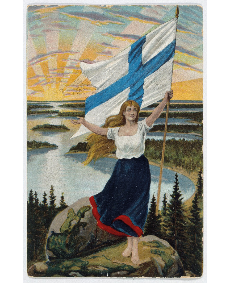
Fig. 1: Ragnhild Sellén, “A Finnish maiden stands on a rock and raises the blue cross flag”, postcard published by Axel Eliassons Konstförlag (1905), Finnish Heritage Agency, CC BY 4.0, https://finna.fi/Record/museovirasto.53F7EC754023DD17ACEF348B0F5415D0.
A look at two maps of Europe from 1789 and 1914—the beginning and the end of the ‘long’ nineteenth century—shows that in this period the greatest geopolitical changes took place at the heart of the continent along an imaginary line that crossed its centre, from Germany to Italy. The myriads of micro-borders that once criss-crossed this longitudinal swathe of the European continent disappeared during the nineteenth century after the initial impulse of the Napoleonic conquests. This formerly splintered territory was replaced by two sizeable territorial units, the German Empire and the Kingdom of Italy, as well as several small and medium-sized states: the Netherlands, Belgium, Luxembourg and Switzerland. In the same period, by contrast, the western half of the continent remained reliably compact from a territorial point of view, with minor border changes. And in Eastern Europe, though they faced wars and revolutionary upheavals, the Habsburg and Tsarist Empires remained firmly in control of their territories and even increased their possessions marginally. This meant an increasing differentiation between east and west: in Western Europe, modern nation-states were emerging while more traditional empires survived in the east, a dynamic that produced its own territorial shifts. An example is the case of the Habsburg Empire around the turn of the nineteenth century. In 1795, during the French Revolutionary Wars, the Habsburgs lost their lowland provinces in north-western Europe to France, but simultaneously acquired the eastern territory of Galicia with the partition of Poland. Yet Galicia’s borders were not as clearly defined as those of the Low Countries, and its linguistic and religious composition was also much more mixed than the Habsburg Empire’s western hereditary provinces, including the lands of the Czech crown.
The exception to this rule of territorial preservation and consolidation is to be found in the Balkans on the European fringes of the Ottoman Empire, which by the end of the nineteenth and the beginning of the twentieth century had transformed into several small independent states.
Cultural Transformation
In the nineteenth century a wave of nationalism spread across Europe, creating political movements among many of the nations and ethnic groups of the continent, from Spain to Russia and from Norway to the Balkans. During the Napoleonic Wars, the fight against external aggression triggered uprisings in many countries based on the concept of the nation. This rallying point did not disappear after the end of the war. On the contrary, ideas of national unity and collective identity, such as people sharing the same language, culture, history, and territory—elements of what the scholar Benedict Anderson called an “imagined community”—started to play an increasingly important role.
Whether they were big or small, independent entities or subjects of empire, various European communities sought to define and assert their national identity. Apart from a shared language, history, culture or religion, a common territory or ‘homeland’ was one of the most important symbols of the nation. The leaders of nationalist movements in Europe wanted to strengthen the abstract idea of a national community with the feeling of belonging to a territorial homeland, delimited by clear borders. For the elites of already established states such as France or Spain, of recently united states like Germany or Italy, and of nations without states like the Czechs, Finns or Slovenes, national identity became more important over the course of the nineteenth century, overshadowing previous regional or religious identities. Defining the national space became a pivotal part of constructing national identity. A process of ‘spatial socialisation’ occurred, by which citizens were encouraged to see themselves as part of a collective identity defined by national territory. In other words, the lines on the map delimiting their living space became one of the symbols of their collective national identity. Nationally minded elites looked upon these borders—frequently shown in maps, school textbooks and atlases—as the most important physical markers of national identity, as well as social, economic, and psychological symbols.
The hexagonal shape of France displayed in atlases and geography textbooks, for example, would become familiar to every French pupil during their school attendance—or at least that was the intention of the French authorities. Finnish borders were personified by the picture of the Maiden of Finland so much that the north-western part of the country was nicknamed “the arm”, as it was easily recognisable as the right arm of the maiden. Similarly symbolic images were depicted on various maps across Europe with the aim of making the nation spatially visible through its boundaries.
These clear-cut borderlines also helped citizens to define who their compatriots were (those living within the borders) and who they were not (those living outside them). This dichotomy, which helped to divide communities into opposing categories, an us versus a them, was very much based on the existence of clear borders between states, regions, and other administrative units. Drawing a boundary between their own nation and those who lived outside the national territory helped state leaders to create a sense of common identity and cohesion among the inhabitants of the territory thus defined. Borders were almost always used by states and nations to symbolise territorial and national unity, irrespective of whether they were shaped according to natural barriers like rivers (e.g. Rhine, Danube), mountains (Alps, Pyrenees, Carpathians) and lakes (Bodensee, Ladoga), or whether they were constructed on the basis of older historical traditions and fault lines (such as the Czech lands or Finland).
However, such national territories were very rarely inhabited by uniformly integrated nations. Many ethnic, national, and religious minorities across Europe were scattered across several countries—including, for example, the German minorities of Central Europe. Such ethnic enclaves were very often seen as subverting efforts to construct nationally homogenous states and, with the rise of nationalism, some became targets of forced assimilation (see for instance the Russification campaigns in the western parts of the Tsarist Empire, or the Norwegianisation of Sami and Kven peoples).
With the spread of nationalism and the increasingly popular notion that state borders should correspond with ethnic boundaries, the scene was also set for irredentism as a challenge to imperialism. The old European empires contained territories and populations that had previously formed parts of other polities, or that were claimed by newly formed states. Essentially, irredentism proposed an alternative redrawing of borders, based on historical and ethnic precedents.
Mental Maps
Maps could be easily drawn on paper and, to a small intellectual elite, national borders might have been evident and meaningful. But the maps within people’s minds, the basic cultural coordinates by which they lived, changed much more slowly in this period, usually due to state intervention, disruption by war, and extended literacy and print culture. In Britain, for instance, the Napoleonic Wars and the consequent military mobilisation increased awareness among ordinary people of a grander scale of territory and identity, though without erasing the imaginary boundaries associated with regional belonging. By the 1860s, ordinary Frenchmen were still very much attached to their pays, or region of origin, and having to leave it in search of work amounted to an expatriation; crossing the regional border was like crossing into a foreign country. Similarly strong regionalisms also persisted after the unification of Italy. In the famous words of Italian statesman Massimo d’Azeglio (1798–1866), once Italy was made, the only thing remaining was to make the Italians: the boundaries of the new nation-state did not yet correspond to the mental borders within which people in the Italian Peninsula lived. Further east, when asked about their origin and identity, a nineteenth-century peasant in the Carpathian Mountains or in the Balkans was likely to answer by reference to their village or declaring their religion, both of which constituted the centre of gravity of their life. A Polish mayor would most likely identify with his native region and only find out from newspapers that he was, in fact, Polish.
A key element in the transformation of the continent during the nineteenth century was the industrial revolution, which went hand-in-hand with explosive population growth, particularly in Western Europe and later in the rest of the continent. The resulting overpopulation set in motion massive waves of emigration, especially to America, but also across Europe as whole. State frontiers may have become increasingly fixed and stable, but thanks to new infrastructure and new possibilities of travel, Europeans also became increasingly mobile and able to escape the gravitational force of tightly demarcated states.
Such population movements were powered by people’s mental maps, in which the centre of imagination often lay beyond native borders, in the nearest city, the capital, or remote destinations such as the Americas. The hopes and expectations that led people to follow the path of emigration could be seen as a consequence of the changing frontier between what the historian Fernand Braudel called the possible and the impossible. Thus, lower transportation costs made it economically possible for many people to cover distances that had previously been insurmountable. The same changes that made American grain competitive on European markets during the nineteenth century also made the emigration business flourish in the other direction. For many people in the Hungarian half of the Habsburg Empire, for instance, the gravitational centre was the ‘West’, variously conceived. Prominent focal points included the imperial capital of Vienna, Britain during the post-Napoleonic Era, and Paris at the time of the great revolutionary upheavals between 1789 and 1848 (and at the end of the century, as the city of grandeur and culture), not to mention the German universities which, in a long tradition, were destinations for study abroad among families of the Hungarian elite.
Another consequence of the industrial revolution was the increased economic and commercial interconnectedness of the continent. The first attempts at economic unification in Europe can be traced back to Napoleon’s Continental System, which targeted Great Britain at the beginning of the nineteenth century. Even after the fall of the French Emperor, the idea of European economic unity was not completely abandoned. Since industrial and agricultural goods often had to be transported over long distances, the economic and custom borders between European states started to be seen as a hindrance to economic growth. New unions and confederations were created (for instance the German Customs Union in 1834) to ease economic and commercial exchanges within Europe, contesting the previous economic boundaries between European states.
Besides overpopulation, cataclysmic events such as the Irish Famine (1845–1852) also acted as motors of emigration. The famine was caused by a failure of diseased potato crops, leading to the deaths of around a million people and compelling well over a million more to take a harrowing journey across the ocean—driven by sheer desperation, rather than dreams of wonderland. In many cases these were people who had never left their villages before and who were now forced into making a transatlantic voyage in the worst of conditions. They were likely to face generational poverty and fall prey to illness, exploitation, discrimination and deceit. Across the European continent German colonists who sought a better life in the east had a saying that encapsulated the fate of émigrés: the first generation faces death, the second generation faces hardship, and only the third generation enjoys the bread.
Borders remained porous and easy to cross for a long time, with passports being rather rare and not strictly necessary for international travel, until the time of the First World War. In the interwar period Austrian writer Stefan Zweig (1881–1942) nostalgically reminisced about his youthful travels to America and India before the Great War, when he was never asked for a passport, nor had he ever seen one. Moreover, passports did not constitute proof of national identity until well into the nineteenth century. For instance, British passports were written in French and granted to both British and foreign nationals until 1858.
However, as borders between states were being consolidated throughout the nineteenth century and well into the twentieth century, border checkpoints and controls became more frequent and commonplace. A hardening of border controls as well as a stronger conflation between passports and national identity started with the economic slump of the 1870s, when a number of European and non-European governments decided to introduce anti-immigration policies of border control. These were aimed at groups of people deemed undesirable—see, for example, the 1885 expulsion of Poles from imperial Germany or the 1905 Aliens Act in Britain against “destitute foreigners”, who were mostly Jews from the pogrom-ridden Tsarist Empire. In the words of the writer Matt Carr, this spelt the beginning of a bordered world based on “paper walls”.
Conclusion
Europe saw a massive redrawing of borders at the beginning of the nineteenth century in the wake of the Napoleonic Wars. It underwent a gradual process of state centralisation and a concomitant process of nation-definition and nation-building, all of which went hand-in-hand with a clearer demarcation of national and imperial borders and the slow but never-complete breakdown of internal, regional borders. Just as physical borders were tightening up and becoming less porous, social and economic pressures set in motion millions of people in search of a better life, making use of new transport and infrastructural possibilities to reach the destinations of their dreams. On the one hand, mental geographies of hope made the crossing of borders and population relocation possible on a mass scale. On the other hand, equally persistent mental maps tied other people steadfastly to their village, region, or religion, and for a long time remained in stark contrast to newly defined state borders. By the time that these mental maps had come to approximate actual state borders and state-directed national identities, the First World War had broken out and set Europe on yet another course of major territorial transformation.
Discussion questions
- Over the course of the nineteenth century, European borders became ‘harder’ and less porous. What are the ways in which borders were tightened that are listed in the text?
- Can you explain why this happened, based on the information provided?
- What were the consequences of this process?
Suggested reading
Anderson, Benedict, Imagined Communities: Reflections on the Origin and Spread of Nationalism (London: Verso, 1991).
Bayly, C. A., The Birth of the Modern World, 1780–1914: Global Connections and Comparisons (Oxford: Blackwell, 2004).
Carr, Matt, ‘Beyond the Border’, History Today 63:1 (2013), https://www.historytoday.com/archive/history-matters/beyond-border.
Colley, Linda, Britons: Forging the Nation 1707–1837 (New Haven: Yale University Press, 1992).
Glenny, Misha, The Balkans: Nationalism, War, and the Great Powers, 1804–1999 (London: Penguin, 2001).
Hupchick, Dennis P., The Balkans: From Constantinople to Communism (Basingstoke: Palgrave Macmillan, 2004).
Mazower, Mark, The Balkans (London: Weidenfeld & Nicolson, 2000).
Ó Murchadha, Ciarán, The Great Famine: Ireland’s Agony 1845–52 (London: Continuum, 2011).
Paasi, Anssi, Territories, Boundaries and Consciousness: The Changing Geographies of the Finnish-Russian Border (New York: Wiley, 1996).
Rieber, Alfred J., The Struggle for the Eurasian Borderlands: From the Rise of Early Modern Empires to the End of the First World War (Cambridge: Cambridge University Press, 2014).
Strath, Bo, ‘Insider and Outsiders: Borders in Nineteenth-Century Europe’, in A Companion to Nineteenth-Century Europe, 1789–1914, ed. by Stefan Berger (Oxford: Blackwell, 2006), pp. 3–10.
Weber, Eugen Joseph, Peasants into Frenchmen: The Modernization of Rural France, 1870–1914 (London: Chatto & Windus, 1979).