7. The emergence of a hybrid hydro-scape in northern Kunene
©2024 D. A. M. Schwieger, M. Bollig, E. Olwage & M. Schnegg, CC BY-NC 4.0 https://doi.org/10.11647/OBP.0402.07
Abstract
This chapter shifts from land and boundaries to consider the management of water in “Etosha-Kunene”, and specifically the materiality of infrastructures linked to water resource management and its social-ecological implications. In north-western Namibia a unique “hydro-scape” has emerged. Before the 1950s, the area was characterised by the scarcity of permanent water places and sources. Between the 1950s and the 1980s, the then-ruling South African administration drilled hundreds of boreholes in the region as part of its apartheid “homeland” policy and “modernisation” impetus. Initially, local leaders and traditional authorities rejected the idea of water development through borehole drilling; many felt that once such a complex and expensive infrastructure was operational, the state was there to stay as the guarantor of water infrastructures providing the basic hydro-infrastructure for vast herds of livestock. Since 1990, the independent Namibian state continued the borehole-drilling programme, especially as part of its drought-management approach. From the 1990s onwards, responsibility for maintaining the above-ground infrastructure of boreholes was transferred to local pastoral communities. Nonetheless, the state once again expanded its reach as material water infrastructures opened the door for national and global governance regimes which increasingly permeated communities, even as the state began to “withdraw” through community-based management policies. The result is a dynamic bricolage of institutions shaped by different practices, power relations, norms, and values. Nowadays, local communities reliably maintain water supply, but not always on an equitable basis for all users.
7.1 Introduction
Political ecology approaches have made lasting contributions to comprehending multiscalar power structures and processes shaping global resource struggles and environmental changes at different temporal and spatial scales.1 Recent contributions have argued for engaging with non-human agencies and thus paying attention to the critical role of materialities and technological artefacts in these processes.2 Still, the role of infrastructures in shaping human-environment interrelations, power relationships, and state-local interactions—especially in marginal environments—has received little attention.3 Likewise, the common-pool resources literature and institutional theory have recognised the influence of technologies (fisher nets, fences, etc.) in guaranteeing sustainable resource use. All the same, this body of research has neglected the political motivations and long-term implications of placing infrastructures in a specific landscape for the co-production of socio-political institutions and ecologies.4 This chapter thus takes the historical construction and making of a peculiar hydro-scape within north-western Namibia as a starting point to shed light on the role of infrastructure in co-shaping emerging power and social-ecological relations, and local resource management institutions.
Drawing on archival sources and long-term ethnographic fieldwork, the first part of this contribution (Sections 7.2 to 7.6) traces some aspects of the negotiation and eventual construction of a dense network of borehole infrastructures in the Kaokoland Communal Land Area (northern Kunene Region), by the colonial and post-colonial state from the early 1950s onwards.5 In so doing, it depicts how the South African administration introduced boreholes in the former South West Africa (SWA) following a twofold aim: i) to sedentarise the local population and expand its presence within this borderland territory; and ii) to increase the economic output of, and to modernise, livestock-rearing practices through what was termed ‘material development’.6 Initially, this borehole drilling programme and associated infrastructure were not welcomed, and were heftily opposed and resisted by local leaders. With time, however, competing chiefs and headmen soon realised that boreholes could be a powerful instrument through which to expand and root their own land claims, regulate access rights to pastures, and develop patron-client relationships and positions of power within a contested political environment7 (also see Chapter 6). Thus, the expansion of the state became a process partly facilitated and appropriated “from below”. The eventual implementation of the programme and the drilling of hundreds of boreholes over the next four decades radically transformed the local hydro-scape. This operation deeply impacted the form of local institutions, land relations, and pastoral economies, changing subsistence and mobility patterns and social ecologies in lasting ways.
The second part of this contribution (Sections 7.7 and 7.8) shows that the current hydro-scape is simultaneously a colonial and a post-colonial manifestation, as borehole infrastructures continued to be introduced in the region after 1990. In this section, we argue that in the post-Independence era, these infrastructures have come to play a central role in constructing a post-independent and post-apartheid state. The borehole infrastructures co-produce a new sort of neoliberal citizenship by “handing over”—to use the government’s words—responsibility for the basic operation and maintenance of the water infrastructure to local actors, or rather, “communities”.8 However, the specific borehole materialities, their historicity, and the demands of boreholes fitted with different technologies in diverse socio-ecological settings, defied the ideal of state retraction embodied by initial water reforms. Before we describe the extensive introduction of borehole infrastructures in the region, Section 7.2 provides a short discussion of Kunene’s previous and inherited waterscapes and management situation.
7.2 Water relations and governance before the introduction of borehole infrastructures
Before introducing numerous mechanical boreholes in the region, natural springs, ephemeral rivers, seasonal pans, rock pools, and hand-dug wells in riverbeds were the key water sources. Rights to access and use of these different seasonal and permanent sources were socially embedded in culturally informed institutions governing shared access to land and pastures (also see Chapters 6, 12, 13 and 14). At the same time, and historically, claiming ownership over more productive and permanent water-places was central to local contestations over territory, power and authority, especially within a context of overlapping group migrations into the region.
In pre-colonial northern Kaokoland, and for the most part of the German colonial period, places with relatively good water availability were usually “owned” or under the guardianship of wealthy otjiHerero-speaking pastoral households descending from immigrant pastoralists (nowadays generally known as ovaHimba and ovaHerero). Headed by men (usually the most senior man in a patrilineage), they were addressed as oveni vehi, owners or guardians of the earth/land:9 although see Chapter 1 for more historical and cultural complexity for Namibia’s north-west. Amongst the otjiHerero-speakers focused on in this chapter, claims to being oveni vehi were usually related to histories and genealogies of first settlement and ritually enacted first-comer status10 (see Chapter 6).
Other land and water using households were related matrilineally or patrilineally to these oveni vehi, or were tied to them through patron-client relationships.11 This patrilineage-place relation was given an historical dimension through the presence of ancestral homesteads and graves at which remembrance rituals were regularly performed; as well as other practices, such as the performances of place-based praise poetry and “oral knowledge” of past household and group migrations.12 In addition, water-sources such as hand-dug wells were essential in embedding kin and ancestral relations within the landscape. It was usually the senior men from a particular household and patrilineage who dug the wells, their households claiming exclusive rights to use or allocate access to such sources.13 These wells involved investing significant physical labour yet relatively little social coordination costs (for digging and day-to-day management). Hence, during this time, a small, clearly defined and closely related group of households were using water and managing surrounding dryland pastures conjointly.14
In the late 19th and early 20th centuries, there were no clearly identifiable chieftaincies in northern Kunene. Wealthy and spatially mobile ovahona (herders wealthy in cattle) and clients attached to them temporarily gained primacy in one place, but might move on to another place in the context of a drought.15 In addition, during the latter part of the 19th century Boer settler communities—the Dorsland trekkers—temporarily (1879–1880) stayed in Kaokoveld at Otjitundua and Kaoko Otavi springs, later moving to south-west Angola.16 From there they launched large-scale commercial elephant hunting expeditions into the northern Kaokoveld almost every year between 1898 and 1908 (also see Chapter 1). Local people hunted mainly for subsistence but were also involved in this form of ivory trade as carriers of ivory tusks.17 Within this context, permanent water-places became an increasingly important ‘social and political resource’18 for claiming territories, and as hubs for agricultural production and for commercial hunting expeditions.19 These places were often claimed through the ownership of firearms which, due to the raiding and hunting economy in existence during this time, had become important technologies for securing power and wealth.20
From 1910 onwards an ‘extremely complex set of relations [was] developing’21 between the different autonomous groups occupying the areas from Sesfontein north to the Kunene River. This complexity gained momentum through the return of powerful, wealthy “warlords” and their followers from southern Angola—many of whom had fled there due to ovaKuena (Oorlam/Nama) cattle-raids and colonial wars (discussed further in Chapters 1 and 6). These re-migrations increased markedly after 1910, when Angola’s administration changed from military to civil rule, and as German colonial rule in Namibia came to an end in 1915 (see Chapters 1 and 2). One group under the leader Harunga Vita (“Oorlog”) Thom, which had their main settlement at Otjiyandjasemo—a place with very good spring water—emerged as a politically powerful minority group after 1910.22 Upon returning to the Kaokoveld, Thom competed for wealth, power, and resources in a context of already established powerful leaders.23
During the German colonial period (1884–1915), the colonial administration did not have a significant direct influence on the resource governance of northern Kunene, a situation that changed radically with the South African colonial government (1920–1990). One of the new SWA administration’s first measures was to identify and install three regional chiefs—Vita Thom, Muhona Katiti and Kakurukouye—each perceived to be representative of different “ethnic” groups in Kaoko, with each ruling over a specific “native reserve”:24 Vita Thom was leader of the “Herero”, Muhona Katiti of the “Himba”, and Kakurukouye of the “Tjimba” sections (also see Chapter 2). As noted above, the authority of these men was not exclusively based on genealogical legitimation as land “owners”: they were (fearfully) respected due to their access to arms and livestock wealth. These chiefs nominated councillors or headmen who supported them, establishing a hierarchical and male-dominated tribal administration.25 The initial favouring of Vita Thom and his followers and the designation of this group as “Herero” by the colonial administration, fuelled existing rivalries and set the stage for future political rifts, divisiveness and struggles over power, territory and resources.26 Many of these “traditional” authorities under the designated chiefs were also wealthy herders who competed not only for state recognition, but also for territorial control at the local level (see Section 7.4).
Despite institutionalising structures of indirect rule, throughout the 1930s and 1940s the colonial state hardly attempted to intervene in rangeland management.27 In contrast, most governmental efforts and resources were directed at developing the “white” settler agricultural economy.28 This situation changed a few years after the rise to power of the National Party in South Africa in 1948 and the official introduction of apartheid state policy and ideology, including in the then SWA. Material development in the guise of “modernisation” entered the political discourse on “native reserve” and later “homeland” policy. This discourse, albeit framed in terms of “development”, became instrumental in segregating and institutionalising structures aimed at controlling the “black” population and the landscapes they inhabited29 (see also Chapter 2). Boreholes and water development in northern Kunene were introduced within this changing and contested political landscape.
7.3 The emergence of the hydraulic paradigm
The introduction of water infrastructure in today’s northern Kunene Region was embedded in a broader set of initiatives of the South African colonial administration to bring “development” (“ontwikkeling”) and modernisation to the then African reserves from the 1950s onwards.30 This change coincided with the declaration of northern Kaokoveld as an “independent” reserve in 1947—placed under the direct authority of the Chief Native Commissioner in Windhoek in 1957—and the onset of apartheid rule in Namibia.31 The introduction of boreholes was also strongly influenced by scientific publications on the region from the 1950s onwards, and international pressure on the South African colonial administration to justify its ongoing colonisation of the territory.32 South Africa needed to legitimise its annexation of Namibia after refusing to convert its mandate over the territory into a United Nations (UN) trusteeship. Therefore, a series of commission reports laid down the concepts of “trusteeship” and “guardianship” as principles of administration within African native reserves, later expanded as homelands. Based on these principles, intervention by the state to promote development became mandatory.33
Concrete recommendations to increase sustainable agricultural output by introducing boreholes in SWA reserves were prominently formulated by South African soil conservation experts who visited the territory in 1951. They strongly argued in favour of more water points to facilitate a rotational grazing system based on camp structures.34 Given that boreholes had been drilled in great numbers and with significant state subsidies on white-owned farms in the 1920s and 1930s, this was not a genuinely innovative technological measure; although ideas to systematically expand these measures to African reserves with substantial capital input, were new. It was also unique that the state would provide a complete infrastructure, own it, and manage it in these areas. In contrast, boreholes on settler and white-owned farms were owned and operated by respective farm owners, despite major state subsidies.35
In the Kaokoland Native Reserve, recommendations for hydrological development were formulated in a letter written in April 1952 by Native Commissioner Eedes in the then Ovamboland, to the Chief Native Commissioner in Windhoek. Eedes argued that concerted development aid would help to ‘uplift’ pastoralists. More boreholes in their areas would lower stocking densities, and more numerous and better-nourished livestock would bring more money to the community and, by extension, development. These arguments gained more prominence as plans for labour export from the Kaokoveld were thwarted a few years later. In 1954 the recruiting office for labour in Opuwo finally closed due to lack of success: the Kaokoveld was no longer regarded as a labour reserve; the future, in the eyes of the administration, now lay in improvement of livestock husbandry. Until then, restrictions on livestock movements and trade across boundaries (which cleared the Kunene Valley of any settlement), as well as vaccination campaigns and measures directed against fire management, had been the main state-driven transformations of social-ecological relations and pastoral economies within the region. None of these changes brought significant new infrastructure.36
Eventually, in 1955, the Chief Native Commissioner made water development a priority task for the administration in the “native reserves” of northern Namibia. He had urged officers to take account of unused lands and asked them to consider whether such lands could be used productively if provided with boreholes:
[w]ater provisioning will, of course, be the most prominent item of the development that has been considered. In this context, it is only required to indicate the number of water points, estimated 8 to 10 miles apart, which would be necessary for the normal demands of the region, taking into account the number of livestock and the availability of land that has not been used yet or not used to its full capacity.37
This policy, oriented towards developing and constructing a new hydro-scape, was initially resisted by pre-Independence traditional authorities and powerful local actors, many of whom were suspicious of the state’s intentions. As pointed out by van Wolputte38 and Bollig,39 their suspicions were not unfounded as this programme was meant not only to modernise local livestock husbandry, but also to win local support within a larger context of organised resistance against colonial rule.
7.4 Local opposition to development40
Van Wolputte41 reports on a meeting of the local administration with chiefs in which administrative officials attempted to appease the local population who had decided to boycott government initiatives to provide new water points. Traditional authorities voiced their concern that they might become indebted to the government and that the government could claim further land in compensation from them later on. In the late 1950s, leaders rejected a governmental donation of R25,000,42 which was meant to spur the borehole drilling programme.
In a meeting in January 1961, the then Native Commissioner Eaton blamed the chiefs in a highly frustrated manner: ‘[e]k verstaan julle will nie die verbeterings hê nie’ (‘I understand you do not want any improvements’). In a meeting in March 1962, an ovaHerero chief openly exclaimed they did not want any money from the “minister” for borehole drilling asserting: ‘ons kan vir ons self sorg’ (‘we can look after ourselves’). While other ovaHerero leaders agreed and contended that they could provide sufficient money to drill boreholes themselves,43 “Himba” and “Tjimba” chiefs disagreed as to what extent monetary help by the government was acceptable. While some agreed with the flat refusal of government assistance, others, such as the prominent ovaHimba leader Munimuhoro Kapika, asserted that they needed further boreholes and that if the government could help it should do so. However, many local leaders were afraid to provide more space for the administration’s engagement in what they perceived as internal affairs. They clearly saw the drilling of boreholes would make them dependent on the government. Potentially, it would entrap them within an infrastructure provided and maintained by an oppressive and segregated state. At the same time, local negotiations over water development were taking place within a context of growing political fragmentation and rifts, partly fuelled by the colonial administration.
Friedman44 has illustrated how, during the 1940s, the administration contributed to the ambiguity surrounding “Himba” and “Tjimba” leaders, by undermining their authority and status within the Kaokoland Tribal Council, as opposed to the clear position of “Herero” leaders: such practices fuelled tensions and gave rise to strongly opposing ‘politico-ethnic formations’ and groups. By the early to mid-1970s, tensions between opposing factions spiralled out of control and a violent regional conflict broke out in 197445 (also see Chapter 6). This conflict was not only about collaboration with the colonial government, but also ‘about power, in which contested rights over leadership, pastures, or poaching territories, and later, the socioeconomic supremacy over the trade monopoly (by the “Herero” section) in Kaoko played an important role’.46
The later part of the 1960s, 1970s, and 1980s, however, brought a crucial turn in colonial water policies. Local opposition waned as political actors realised that boreholes could be a socio-political instrument through which they might cement their chiefly power, and expand territories or claim autonomy from larger chieftaincies for shared land use communities. Local chiefs and (later) headmen were given the authority to decide where boreholes should be placed. They could develop pastures according to their own and their followers’ wishes, claim ownership over specific water points, and, by extension, territories. The specific materiality of the borehole infrastructure also provided a pervasiveness and presence in the landscape not previously afforded by wells, which could only be dug in specific places (e.g. riverbeds). Hence, boreholes provided a new technology for expanding and rooting place-based settlement histories and both ritual and political authority (see Section 7.2).47
7.5 Borehole-drilling and the expansion of
state administration48
Since the early 1960s, the administration endorsed and drilled several boreholes a year. A major drought in the late 1950s/early 1960s made the situation more urgent from the administration’s perspective. It also convinced administrators that the government should finance borehole-drilling and not wait for contributions from the stamfonds (homeland trust fund) of Kaokoland’s chiefs.
The Odendaal Commission, which visited the region in the early 1960s, focused its discussions almost entirely on the issue of boreholes. Unsurprisingly, the finalised Odendaal Report49 recommended boreholes as crucial to economic development in the Kaokoveld.50 Water was regarded as the fundamental resource for a rapidly growing population and had to be exploited with new technological means. The immense bureaucratic fervour of the drilling programme, which got off the ground in 1962–1963, was remarkable.51 Each borehole was registered in a complex way: communication in the planning phase and data on the actual drilling, depth (in some cases more than a hundred metres), and test-pumping to establish yield, were carefully filed. Likewise, communication on the tenders for fitting boreholes with pipes and adequate pump systems was documented in detail.52 Money for boreholes was entered into yearly budgets of the administration from the early 1960s onwards. For the year 1962, for example, some R20,000 was budgeted for new boreholes (drilling plus fitting).53 For each borehole, a detailed geological evaluation was conducted—this was, at least, what the regulations required. In reality, however, the process was relatively swift and often did not consider ecological concerns. Sometimes boreholes were even drilled against the judgement of officials. In a letter written in August 1962, the Chief Bantu Commissioner in Windhoek expressed his understanding of an official’s reluctance to give orders for drilling a borehole that chief Muinimuhoro had applied for. The official had voiced ecological considerations as an argument against this borehole. However, his superior argued that ‘in this time of unrest’54 it was of the greatest importance not to give the local communities any pretext to criticise the government. He feared they could use the denial of a borehole for propaganda against the colonial administration.
Boreholes were drilled in large numbers in Kaokoveld throughout the 1960s, 1970s and 1980s. The ideal administrative process ran as follows: at the beginning of the year, the agricultural office in Windhoek detailed how many boreholes could be drilled with the funds available. The actual decision about where boreholes were drilled was left to the local administrative staff in Opuwo. There was never a comprehensive plan detailing where boreholes should strategically be sunk to provide maximum grazing at a sustainable level. Local chiefs applied to the Department of Water Affairs to place a borehole in their area. Local officials then consulted them to identify an optimal location.55 Usually, chiefs brought up their wishes in the meetings with the administration. They requested boreholes for existing cattle posts and permanent settlement places to replace or complement wells. But the installation of many others followed this simple reasoning: wherever there was still some grass left, a borehole offered the chance to expand livestock husbandry and increased the options of a chief to attract followers and incorporate territories.
In the 1960s and 1970s, requests for more boreholes took up considerable time during the formal meetings of the administration with local chiefs. The chiefs usually tried to convince the administration to fit the borehole with a diesel engine, which increases the yield. However, the administration often opted for wind-pumps, the cheaper solution, for this technology did not imply providing diesel regularly to the communities. Additionally, borehole infrastructures usually include a reservoir for storing the pumped water and one or two drinking troughs. Chiefs from different group factions often competed for boreholes, and an administrator in the late 1970s voiced his concern that water development was indeed what the traditional leaders were after and what tied them closer to the state apparatus:
[i]t is obvious that “water” is the central concern of the chiefs and all ask for “water” [development] […] The development of boreholes and the maintenance of water supply infrastructure is of the utmost importance to gain the trust of local inhabitants.56
For many years, and into the present, the Water Affairs Department has been the most populous administrative section in order to deal with the immense bureaucracy involved in drilling boreholes. The Water Affairs officer in Opuwo tried to match a list of applications for boreholes handed in by chiefs to his budget and finally decided which applications were to be approved. Geologists established the exact location of each borehole. The Department of Water Affairs tendered the drilling, and a contractor came to sink the boreholes. It employed a white superintendent and 60 African workers who earned R50 to R80 monthly. While drilling a borehole and fitting equipment were tendered out on behalf of the Ministry for Agriculture, the Department of Water Affairs ran the maintenance of the infrastructure and provision of diesel for engine pumps.57
The registration of boreholes by the administration also included a quick estimate of their hydrological potential.58 The suitability of wells was judged by looking at their potential contribution to livestock husbandry and from a local political perspective. Loyal chiefs were rewarded with boreholes; through them, they could show their followers they could beneficially influence the administration.
In the 1950s, 43 boreholes were drilled in total. All of them were located around Opuwo or to the south-east of it, reflecting the easy accessibility of these places and close contact between administration and traditional authorities from these areas. During the 1960s, another 136 boreholes were sunk, and in the 1970s, 128 boreholes were installed. The Kaokoveld was now covered with a network of boreholes, some equipped with wind pumps, some with motor-driven pumps, and others with hand pumps. In the 1980s, another 57 boreholes were added, and drilling continued well into the 1990s (see Figure 7.1). Apart from the administration’s use of the borehole programme to win local trust, bolster the authority of chiefs, and support access to pastures, it also became a tool for socio-spatial segregation. According to van Wolputte,59 ‘whereas roads, for instance, were forcibly constructed to facilitate control over homesteads, people and animals, water holes were used as a strategy to separate the different groups inhabiting the northern Kunene region’; the goal was to fix the ‘Ovahimbas in the north, Hereros in the south and Ovatjimbas in the north-west’.60
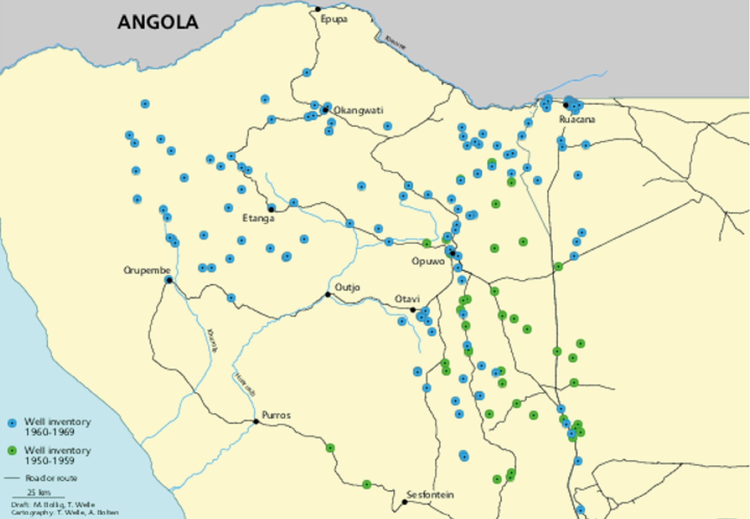
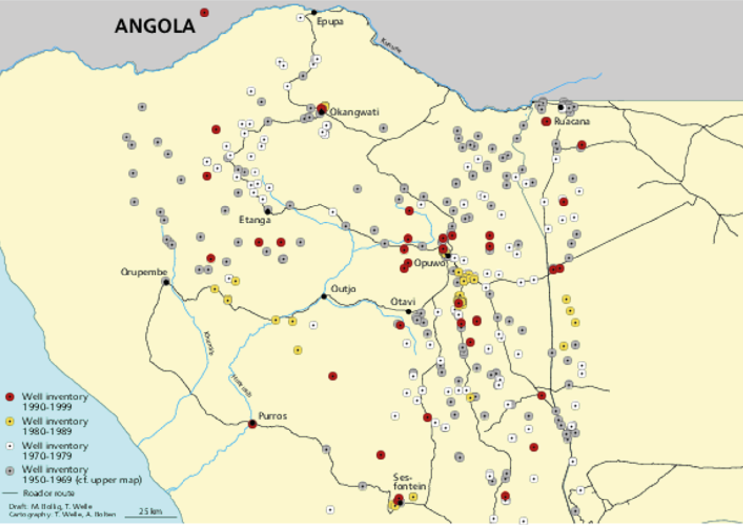
Fig. 7.1 Map of boreholes established in the 1950s and 1960s (above), and map of all boreholes established until 1999 (below). Source: Authors’ database, CC BY-NC-ND 4.0.
7.6 Consequences: Changing patterns of mobility and related institutions, rangeland vegetation, tenure, and livestock numbers
The impact of the borehole drilling programme on social-ecological interactions and local place-relations was profound. Boreholes were the first enduring material evidence of the state in much of the Kaokoveld landscape, inextricably linked to the extension of a network of bush roads and paths. New roads into the veld had to be bulldozed and maintained to drill and service these boreholes. At the end of the 1970s, nearly all settled places were connected by roads and were accessible by the administration. Figure 7.1 shows that the development of the hydro-scape was unequal: the eastern part from north to south received more boreholes than the west, except for the area around Etanga. The south-western part of the Kaokoveld from Orupembe towards Sesfontein received the least number of boreholes. In other words, the state gradually expanded into northern Kunene through a network of roads and boreholes that effectively and irrevocably transformed the local social-ecological system.61 At the same time, it provided an entirely new infrastructure fitted with mechanical pump technologies, which tied mobile livestock producers to a state-controlled hydrological system.
This implementation of a new hydrological infrastructure had three pertinent consequences with regards to natural resource management and environment: 1) a rapid and profound increase in livestock numbers; 2) a transformation of mobile land-relations and regional migration patterns; and 3) changes in institutions linked to natural resource and land management.
Livestock numbers increased throughout the 1950s and, after a major drought in the late 1950s/early 1960s, nearly tripled by the early 1970s (see Figure 7.2). Although rainfall dynamics (linked to primary productivity) show a strong relationship with increased livestock numbers in certain years, it is tempting to link increases in livestock numbers to the introduction of the borehole drilling programme during and after the 1950s.
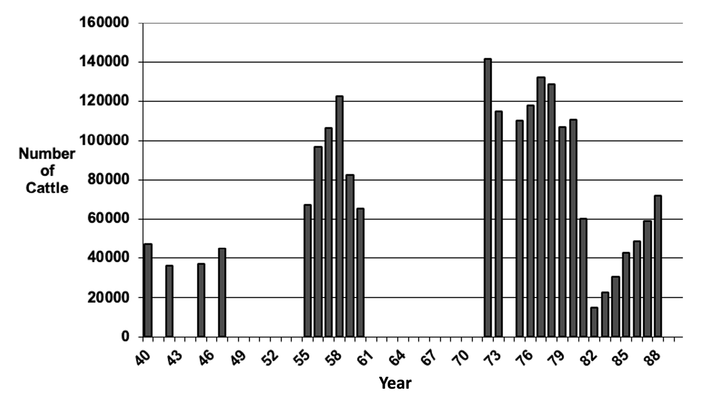
Fig. 7.2 Graph showing the dynamics of cattle herds in Kaokoveld between 1940 and 1990. Source: Created by chapter authors from data held by the Veterinary Extension Service at Namibia’s Ministry of Agriculture (no data for the missing years could be obtained), CC BY-NC-ND 4.0.
Developing a network of boreholes in former dry-season grazing areas between the 1960s and the 1970s led to a reversal of previous mobility patterns and land relations. Before the 1950s, herds had stayed close to few permanent water points, like wells and springs, for most of the year. Herds moved to outlying pastures only during the rainy season, using seasonal pans and streams. As soon as these seasonal water sources had dried up, they had to return to the permanent water points. With mechanical boreholes capable of supplying water throughout the year, herds could instead remain in the former rainy-season areas during the long dry season, as they were no longer dependent on rainwater. Therefore, boreholes made much broader areas accessible for grazing and settlement.
Consequently, new local rules had to be negotiated and developed in many parts of Kaokoveld to address questions about regulating access to these newly won pastures and land, including in regard to sustainability. The administration began to implement administrative reforms along with the infrastructural developments. In conjunction with the drilling of boreholes, the administration divided Kaokoland into separate neighbourhoods, eventually creating 36 so-called ‘wards’ (otjiwyke) (see also Chapter 6). These wards were to be administered by 36 state-salaried “Himba”, “Herero” and “Tjimba” headman and sub-headman, who were incorporated into larger chieftaincies. This mapping of wards was facilitated both by the borehole drilling programme and the parallel construction of a large network of roads.62
Locally, the rules of good grazing (ozondunino yomaryo) evolved in the course of the 1970s as a reaction to implementing the borehole programme. Prefiguring the later institution of Auxiliary Game Guards (AGGs) and Community Game Guards (CGGs) (see Chapter 2), grazing guards (ovatjevere vomaryo) were nominated in each ward. These persons were instituted into their office by way of a community meeting. The fact that these men were also addressed as ovapolise vomaryo (grazing police) may indicate that they were regarded as an extension of the “homeland” bureaucracy. The development of rules for proper conduct concerning grazing was an attempt to minimise the chances of conflict.63
The social set-up controlling natural resources changed in other ways: chiefs had been essential to bring boreholes, and they thereby extended their control over natural resources. While previously it was generally senior men, or rather, wealthy households, who controlled water points on a kinship basis, now it was administrative headmen and chiefs as intermediaries of power controlling natural resource management. Given that chiefs and headmen still needed to gain local recognition to legitimise their claims to authority, however, political authority had to be continually ritualised through place-based practices, as described in Section 7.2 with regards to water places before the introduction of boreholes.64 Thus, the management unit for organising grazing, water and land access became the chieftaincy, composed of affiliated wards administered by headmen.65
The change in the mobility pattern also generated significant ecological changes. The pre-1950s system favoured perennial grasses, with intense grazing on outlying pastures only during the rainy season (i.e. for only three to four months during the growth period). In contrast, the new mobility pattern implied intense stress through grazing during the dry season, which disadvantaged perennial grasses, and advantaged annual grasses. The new rules stipulated that outlying pastures should not be grazed during the rainy season, ensuring that annual grasses were not disturbed during their main vegetation period. Annual grasses were protected until they had developed seeds and their reproductive success was granted. In contrast, perennial grasses were massively disturbed when, due to the lack of soil moisture, they could not sufficiently recuperate. This process led to a relatively rapid change from a pasture dominated by perennials to a range dominated by annuals in several areas.66 Under these conditions, Sanga cattle (the dominant cattle species in the region) often resort to browsing trees and bushes when the grass is depleted, and in situations of drought, pastoralists also collect pods of Faidherbia albida to feed them.67
Other circumstantial evidence of these changes in grass vegetation is the absence of veld fires. Until the 1940s, there were repeated warnings from the administration that any intentional igniting of veld fires would be severely punished. However, veld fires regularly occurred throughout the 1930s and 1940s and into the 1950s. After the 1950s, no significant veld fires could be recorded. This might indicate that a grass layer of perennial grasses had been replaced by a grass layer of annual grasses, with dominance of annual grasses implying less biomass and making the rangeland less susceptible to fires. Nowadays, only a few veld fires have been reported without any indication of scale.68 Thus the infrastructural change of the hydro-scape brought about a transformation of the vegetation cover which has lasted until today.69
These observations conclude the first part of this chapter focusing on the emergence of the regional hydro-scape, especially during the South African colonial period. Now, we turn to the second part, which illustrates its dynamic trajectory in the post-colony.
7.7 The post-colonial hydro-scape:
Post-Independence reforms and policies
After Independence in 1990, the new Namibian government tasked the Ministry of Regional and Local Government and Housing to formulate a decentralisation policy to provide direction to future programmes in the country. The main reason for instituting such a strategy was to ‘enhance and guarantee democratic participation of people at lower/grass-root levels’.70 On this basis, the government attempted to redress the injustices of colonialism and apartheid that deprived large parts of the Namibian population of political participation and socio-economic development.71
The Namibian government estimated in 1990 that 50% of the rural population had no access to a reliable source of safe drinking water.72 The solution to these challenges was twofold: sinking more boreholes and delegating managerial responsibilities of all these infrastructures to local communities. In the process, the formulation of the Water and Sanitation Policy (WASP) in 1993 was pivotal: it furthered the expansion of rural water supplies in neglected parts of the country and set the cornerstone of community involvement to foster participation and local empowerment. This approach implied that water provision should no longer be organised via traditional authorities (TAs) but directly with communities. Moreover, the bureaucracy connected to water provision was maintained and extended, with several donor-led projects ploughing more money into the Directorate of Rural Water Supply (DRWS). In terms of infrastructure construction, this investment translated into the installation of approximately 10,000 boreholes by 1996, in all communal areas, i.e. the former homelands, now the Communal Land Areas as designated by the Communal Land Reform Act of 2002.
Between 1991 and 1998, access to safe water in rural areas rose from 51% to 65%.73 Today, boreholes continue to be constructed, especially as a mechanism to cope with the effects of drought in communal land areas by opening new pastures.74 In doing so, the state has been supported by international NGOs, such as the Red Cross and ICEIDA, an Icelandic Development organisation: the latter installed 33 boreholes fitted with solar pumps in northern Kunene between 2007 and 2010.75 In contrast to diesel pumps, which require fuel and oil regularly, photovoltaic installations can be expensive in the event of theft, and challenging to repair in the case of damage. Their installation might significantly reduce conflicts about monthly contributions for diesel, but it may also stimulate them when solar panels are stolen or vandalised. Detailed, long-term studies about the implications of these technologies are yet to be conducted. Still, stakeholders, including government workers and farmers, see a complete shift from diesel- to solar-powered pumps as a desirable and plausible scenario for the future, especially in terms of lower day-to-day operating costs.76
The WASP was directly informed by formulas of global environmental governance and reflecting the new approach to water resource management in the Dublin Agenda 21, which emphasised principles of sustainability, participation, and recognition of the economic value of water.77 WASP stipulated that over ten years, the responsibility for managing, operating, and maintaining water installations in rural areas would be progressively given to newly formed community-based organisations of local users (but not to individual users). Community members using one borehole were to organise themselves into Water Point Associations (WPA), elect Water Point Committees (WPC), and conjointly develop their own rules for the management of the water infrastructure in their villages, including regulations to cover the costs of operation and maintenance.78 In the early 1990s international organisations such as Africare helped the Ministry of Agriculture pilot these structures in, for example, the Damaraland Communal Land Area of southern Kunene Region.79
Consequently, over 320 WPA have been founded throughout the Kunene Region since the mid-1990s.80 The process of establishing a WPA, the election of committees, and the development of water point management plans, were supported by extension staff from the regional office of the DRWS in Opuwo (or by NGOs acting on behalf of and/or in coordination with them). The extension staff also advised which rules were to be included in the management plan, oversaw the election of a first water-point committee, and supervised the registration of the users as a WPA.
Menestrey Schwieger,81 Kelbert82 and Linke83 found that DRWS extension staff workers in northern and southern Kunene had very clear ideas about which rules for managing boreholes should be adopted. The DRWS extension staff recommended several strategies for funding the water point: to collect the contributions according to the number of animals each household owns (e.g. 1 N$ per head of cattle and 50 ¢ per goat/sheep, both per household per month); to introduce a water-point membership fee (N$20 per adult per year to acquire the right to have a voice in the WPC meetings); a household levy (N$10 per household per month for the human consumption of water); and special conditions for external users (i.e. that they would have to pay more than the permanent settlers for using the water point: N$2 per head of cattle and N$1 per head of small stock). Furthermore, the extension officers recommended imposing penalties in the form of fines or exclusion from the water point whenever users breached the rules. After the management plan for the water point was discussed and decided upon, the corresponding rules were jotted down by a DRWS staff.
Regarding the establishment of local WPC, the extension officers also standardly instructed communities to elect individuals for the following positions: a chairperson responsible for providing overall direction to meetings and monitoring the work of the WPA and the WPC; a secretary in charge of organising meetings and taking minutes; a treasurer for collecting contributions and ‘keeping the money safe’; and a caretaker accountable for the maintenance and day-to-day operation of the water point.84 During this process, the extension officers advised headmen not to be part of the local WPC and insist that young men and women should be part of the board to promote participation and gender equity. However, these conditions were only partially fulfilled.85 In most cases, (elder) women filled only 26.9% of the positions, including the WPC treasurer, due to their role as money keepers in private domains. Young men, in contrast, dominated in the secretary and caretaker roles, while older men usually constituted chairpersons. In this context, we have observed that headmen (and other wealthy influential men) still found ways to strongly influence water point management issues in their favour, as discussed in Section 7.8.
7.8 Implementation, practices and consequences
Local water users voiced their concerns and objections when they were tasked with collecting money contributions to operate their boreholes. Menestrey Schwieger,86 for instance, reported heated discussions between villagers of Ombaka, including the local headman and the DRWS staff, when the latter were “handing over” managerial rights over a new borehole installed on-site. In this context, the headman vehemently reproached the DRWS workers, saying that they and the new government just wanted to make them poor, and that it was a scandal they had to pay for water. Other residents also wondered why now, after Independence, they were being requested by their own government to pay for water. The DRWS staff responded that they were not trying to impoverish anyone. They stressed that after Independence, people had to assume responsibility for themselves and that part of these responsibilities would be to operate and take care of the water points the government provided. Against this background, refusing to assume the costs of operating the diesel pump was not an option, as this action would only harm the community—not the government. The dependency on this infrastructure was too high due to high population and livestock numbers. This situation was not unique to Ombaka; people in numerous settlements in Kunene found themselves in a similar position, resigning themselves to the fact that they now had “to pay for water”.
During this “handing over” process, most users formally committed in their management plans to collect payments according to the number of livestock each household owns.87 Our interviews and observations, however, reveal that many WPA never applied this rule. From 56 communities, only 25 (44.6%) continued with this rule, whereas in 24 cases, it was never used. In other words: money was de facto collected differently to the structures in the management plans with households having to contribute the same amount of money regardless of numbers of livestock—a practice often imposed by “big men” drawing on their bargaining power based on patron-client relationships and authority.88 It was often difficult for other community members to impose sanctions on their wealthy neighbours, often kin, in cases of rule breach.89
Other rules suggested by the DRWS were not always implemented by the WPA either. For example, special conditions for external users were often dismissed, particularly during drought. Incoming herders were generally permitted to get water at the local borehole without paying an extra fee; in some cases, they were even allowed to access water free of charge since this was “the right thing to do”. In this context, maintaining extended familial networks is crucial to secure possible future access to pastures and water beyond one’s home area, especially in times of need.90 Similarly, when less affluent individuals could not pay the water point contributions, the WPC did not automatically impose sanctions on them, such as excluding their animals from using the water point. On the one hand, it is well recognised that anyone could occasionally go through this experience, primarily if it is known that the person was regarded as poor. On the other, denying water for someone’s livestock was equated with “killing the person” since it threatened their main means of subsistence.91
Against this background, the blueprints suggested by government were not really adopted verbatim because they contradicted the interests and authority of powerful actors at local levels: they clashed with existing norms and values, and in some instances, they did not correspond with local understandings of gender roles and existing water management practices.92 Moreover, the reforms have put extra economic pressure on poor households, contradicting goals of promoting equitable socio-economic development for all.93 Despite this situation, communities usually acquired diesel on time, organised spare parts for the above-ground infrastructure, and avoided prolonged water shortages.94
Concerning interconnections between water and land management, however, some continuities between the colonial and post-colonial hydro-scape can be observed. As noted above, water and borehole-management are emplaced and thus inextricable from land management. In northern Kunene post-Independence, the social histories of boreholes are often strongly politicised and can become points of contestation between competing lineages, headmen, and factions vying for authority, recognition and land-rights:95 including contestations over who initiated their drilling and facilitated such development locally, who was consulted, and what intentions or relations with the colonial administration or state were and still are. Today, senior men from first-comer households as well as local headmen remain closely involved in water-management, despite DRWS staff recommendations (as noted above), as an arena for re-asserting place-based authority, or to contest the territorial incorporation of places within larger chieftaincies.
The WPA membership has also become a crucial tool for denying or formalising local residency, especially in the case of drought-related in-migrations by herders and livestock and land disputes (see Chapters 3 and 6). Such membership can be denied to newcomers as a symbolic form of exclusion and non-belonging, especially where newcomers are perceived to have settled without the pertinent permission of the local community. In addition, the specific materiality of boreholes has meant they have become sites of confrontation and conflict within land and grazing disputes, specifically concerning competing models and values of land-use. Residents have locked the diesel engines, or removed and hidden the engine, to exclude in-coming herders from accessing water and seasonal pastures. Given that the refusal of water represents a major cultural taboo, such cases often erupt in conflict, including violent conflict, and in one instance required intervention from the governor.96
7.9 Discussion
The emergence of the hydro-scape in Kunene has its roots in the South African colonial project of expanding its presence in the region, increasing the agricultural output of communal lands, and controlling the local population through segregated development and apartheid. Local chiefs and headman rejected the massive introduction of boreholes at first, but then instrumentalised the initiative to increase their socio-political power, including their influence over use of and access to land and water resources. In this context, boreholes were introduced in large numbers often without proper planning and ecological considerations. This process implicated changes in pastoral mobility patterns, land use practices and rangeland vegetation, which have lasted until today.
After Independence, the Namibian government continued drilling boreholes in this part of the country while attempting to introduce new ways of water governance through various reforms. The policy within which this continuity of infrastructural expansion occurs is embedded within a developmental discourse different from the colonial apartheid state. The provision of water infrastructure in this post-colonial context is aimed at promoting equitable social and economic development. As Schnegg and Kiaka97 mention, this transfer of water infrastructure’s basic operation and management responsibilities to local agents occurred through a community-based management strategy informed by scientific and neoliberally driven resource management models, advocating state withdrawal and resource commodification as discussed and endorsed at a global level98 (also see Chapter 5).
In this context, borehole infrastructures mediated the dynamic relationships between populations and the state.99 The handover of borehole infrastructures created a new sort of citizenship in the post-apartheid era, in which individuals and communities should be empowered by taking responsibility for their own resources and decisions regarding how they are managed and shared. This process can be interpreted as an attempt by the new state to distance itself from the apartheid administration and the paternalistic relations it perpetuated.100 At the same time it is essential to emphasise that while post-colonial government framings like “handing over” suggest that the state is making a “gift” to the community, this gift also came with two challenges: the state stopped supporting communities with diesel for their engines; and the infrastructure requires regular maintenance and occasional repairs from which the state also stepped back. “Handing over”, therefore, also meant handing over water management costs.
By contrast, the materiality of the infrastructures embodied by a dense network of boreholes within a vast and mountainous region also delimited the agency of the state in negotiating its withdrawal from rural water management and supply within this region. For instance, the initial idea of these water reforms was to hand over the ‘full ownership’ of boreholes to local communities within ten years.101 ‘Full ownership’ implies that users should become not only responsible for purchasing diesel for engine pumps and purchasing and replacing spare parts, but also to be responsible for major repairs below ground—such as, re-drilling and exchanging pipes—which are costlier and require a higher level of know-how. The government’s responsibility at this stage would be assisting WPAs in selecting contractors and negotiating contracts for repairs and replacement.
According to interviews with government officials in 2010, this last phase of the community-based water management strategy was put on hold by the Permanent Secretary of the Ministry of Agriculture, Water, and Forestry, as there were concerns over whether the communities could de facto deal with these responsibilities. In this context, it is essential to mention that the contribution of money for operating the water points was a burden for many households, and only a few WPAs managed to accumulate savings: according to our data collected across more than 50 communities the maximum recorded amounts to N$3,000. Spare parts and diesel were only available in towns that were difficult for many people to reach due to the lack of public transport and privately-owned cars. Moreover, and to the frustration of many, large parts of northern Kunene previously had no mobile network coverage. The northern Kunene Region is also categorised as the poorest in the country according to the last poverty report102 (see Chapter 3), and remains marginally integrated into labour and sales markets.
Underground repairs require transporting long and heavy pipes, special vehicles, and technical knowledge: this requires resources and economic capacity difficult for many people and livestock farmers to bear. Thus, the state realised that full ownership might financially and logistically be too large a burden for local livestock farmers and pastoralists. In fact, during the last years, the state continued to repair major damages, such as breakdowns, worn-out equipment, and borehole rehabilitation. It provided a follow-up service to the communities by checking if the money contributions were made and advised if there were any problems with implementing the management plans. Therefore, the boreholes’ materiality to some extent delimited the agency of the state, in its attempt to re-negotiate paternalistic relations and understandings of the state inherited from the colonial administration: the infrastructures remained as ongoing legacies of the South African colonial period, embodying particular understandings of the state’s role and demanding state resources.
The new government ideals of WPA, WPC, and management regulations were thus marginally adopted by actors at the local level. State attempts to introduce and engineer specific ‘institutional infrastructures’103 within the hydro-scape and prescribe how water management should occur were by and large unsuccessful. Local practices and changing socio-materialities,104 including the demands of mobile land relations and pastoralism, led to the emergence of different institutional dynamics governing the sharing and use of sets of interrelated boreholes. Here, water management did not simply function according to “crafted” rules and sanctions around boreholes to promote cooperation and equity.105 Instead, it resulted from a bricolage process,106 where ideas, global influences, local (path-dependent) institutions, power asymmetries, norms, and values de facto influenced how water is supplied and distributed.107 These processes did not always result in institutions regarded as fair by all water users. The state invaded the local arena with specific ideas and suggestions about how water should be managed; but local players, local institutions, power-relations, and micro-politics determined how these changes unfolded.
This discrepancy between post-Independence policies and their respective implementation does not only apply to the water sector but also to other similar community-based initiatives, such as the wildlife conservancy programme (see Chapters 2, 3, 5 and 17). In collaboration with NGOs, the post-Independent government promoted communities to form communal area conservancies to address these injustices and promote the “sustainable use” of wildlife, delegating wildlife management rights to local people while creating incentives for conservation108 (although see discussion in Chapters 3, 5 and 11). So, far Kunene has 38 conservancies.109 The communal conservancy programme has been considered a success in Kunene from an ecological perspective as the numbers and diversity of wildlife increased until 2011.110 Since then, a multi-year drought, game harvesting and animal migration, have contributed to a decline of wildlife in the region, especially of prey species.111 From a socio-economic point of view, the picture is more complex: a more critical orientation towards the conservancy model seems linked with a perception that the implied costs outweigh the benefits (also Chapter 5).112
Against this background, people on the ground dealing with the challenges of resource management continually make demands on and have specific expectations regarding the state. Some people talked nostalgically about the colonial past, for instance:113
the government used to say that the people must not get thirsty, not even a bird. All must get water, and they did everything they said they would do when they said they would do it. The drum never got empty; we used it until twenty-five litres were left in it. The government came, put in more diesel until it was full, and went again.114
Another informant’s statement revealed how the new state was perceived as not taking care of them anymore:
in the past, we had another government that gave us everything. The government was breasting us like a baby. Now, we don’t think that this idea [the community-based management strategy] is good because we are not getting milk anymore.115
These quotes must be understood as part of a larger discourse of critique in Kunene towards the government as a historical product.116 Many people in the region expressed nostalgia for South African rule despite the brutality, oppression, and violence of apartheid. This was because of their discontent over changes that had taken place in the provision of state services and entitlements, including in rural water supply and other sectors like education, health, and drought relief, which people feel have deteriorated under the post-Independence state.117
7.10 Conclusion
From a political ecology perspective, we commenced this contribution by advocating the importance of understanding the role of infrastructures in shaping social-ecological relations and local resource management institutions. In doing so, we used the historical construction and emergence of the hydro-scape in north-western Namibia as an example. On this basis, we showed how government interventions, visions of development, and the introduction of infrastructure in the Kunene Region irrevocably transformed social-ecological interactions, institutions of resource governance, and social institutions. We traced the practices of the state apparatus, discussed local resistance and power dynamics, and detailed the consequences of the government programmes linked to the establishment of far-flung water infrastructure. The targeted change of the environmental infrastructure conformed to governmental visions of separate development and agricultural modernisation. Hence, institutional dynamics for common-pool resource management could be better understood considering the materiality of the infrastructures and the socio-historical processes they are linked to.118
In this respect, we also illustrated that whereas the emergent network of boreholes (and other infrastructures) co-produced the gradual expansion of the colonial state, in the post-Independence and neoliberal context, the materiality of the infrastructures once again played a key role in the negotiation of local-state relations.119 The boreholes and their specific infrastructures allowed for a different state penetration within this region: departing from a centralised policy during colonial times, the post-Independence decentralisation reforms attempted to engineer new norms and rules, sharing economies and understandings of citizenship through the hydro-scape. Moreover, extension officers (or NGO personnel working in coordination with them) tried to empower communities by limiting the participation and influence of TAs in the formation of WPCs (and conservancy committees) and influencing WPAs decisions. The result was an institutional bricolage, shaped by dynamic power relations, resistance and various norms and values embedded in kinship and local practices.
Given this context, if the state handed over the full ownership of boreholes to local communities and did not keep on carrying out major repairs, local users might potentially remain without water, which would feed the general discourse of critique towards the post-apartheid state within the region. What we see in practice is a form of co-management, where the state carries out urgent repairs in the underground apparatus, and local communities manage their water points in ad hoc ways and/or follow their own solutions to avoid shortages in the water supply. Furthermore, the hydro-scape and its infrastructures give agency and power to local actors who demand state involvement and encounters with state officials at the local level. The DRWS staff still visits communities to solve major problems with the water supply. Therefore, the state is under pressure and continually drawn into the rural water supply and, by extension, into other sectors.
For the future, adjusting and improving this way of co-managing resources, might be a more realistic strategy, not only in the water management sector but also in other conservation initiatives, such as wildlife conservation. Research has shown that if community-based strategies are to be sustained at scale, local institutions need a “plus” that includes long-term external financial support, as well as technical and managerial advice.120 With regards to the water management dynamics presented here, such measures could include equipping all boreholes with solar pumps (with low-running costs); introducing water usage subsidies for the poor; supporting communities (e.g. through extension staff) in terms of monitoring, rule-enforcing, and co-financing of repairs; and/or returning operation and maintenance responsibilities to the state.121 Certainly, the practical implementation of such measures would imply various kinds of economic investments and political efforts, which would require careful evaluation; yet the potential benefits in terms of poverty reduction, less intra-community conflict, and more reliable water governance in the region would be well worth these efforts.
Archive Sources
NAN, SWAA 1068, A138/22, C. Ross and J.C Fick, Report on visit to South West Africa, Section Soil Conservation and Extension, 31.7.1951.
NAN BAC HN5/1/3/18 Kantoor van die Hoofnaturellekommissaris, WDK Naturellesake Omsendbrief Nr. 17 of 1955, 26.8.1955.
NAN BOP 5 N1/15/6/8 Notule van Vergadering met Hoofmanne, 20 to 23.3.1962.
NAN BAC HN5/1/3/18, numerous files on the planning, registration and tendering of boreholes.
NAN BAC HN5/1/3/18 Blom, L. Horn J. K. Linning, P. Meyer n.d. [probably 1963] Boorplekke Kaokoveld.
NAN BAC HN5/1/3/18 Hoofbantoekommissaris van SWA an Administratiewe Beampte Ohopoho, 27.8.1962.
NAN BOP 5 N1/15/4/1 Notes of a meeting, Versammlung am 13.11.1978.
Bibliography
Africare 1993. Rural Water Supply Maintenance in the Kunene Region, Republic of Namibia. Windhoek: Unpublished report to the Africa Bureau of the United States Agency for International Development (USAID).
Agrawal, A. 2003. Sustainable governance of common-pool resources: Context, methods, and politics. Annual Review of Anthropology 32(1): 243–62, https://doi.org/10.1146/annurev.anthro.32.061002.093112
Anand, N. 2011. PRESSURE: The PoliTechnics of Water Supply in Mumbai. Cultural Anthropology 26(4): 542–64, https://doi.org/10.1111/j.1548-1360.2011.01111.x
Bennett, J. 2010. Vibrant Matter: A Political Ecology of Things. Durham: Duke University Press, https://doi.org/10.1215/9780822391623
Bleckmann, L. 2012. Colonial Trajectories and Moving Memories: Performing Past and Identity in Southern Kaoko (Namibia). Unpublished PhD Thesis, Social and Cultural Anthropology, Faculty of Social Sciences, Institute for Anthropological Research in Africa (IARA), Catholic University of Leuven.
Bollig, M. 1998a. Power and trade in pre-colonial and early colonial northern Kaokoland, 1860s-1940s. In Hayes, P., Wallace, M., Silvester, J. and Hartmann, W. (eds.) Namibia Under South African Rule. Mobility and Containment, 1915-1946. London: James Currey, 175–93.
Bollig, M. 1998b. Framing Kaokoland. In Hartmann, W., Silvester, J. and Hayes, P. (eds.) The Colonising Camera: Photographs in the Making of Namibian History. Cape Town: University of Cape Town Press, 164–70.
Bollig, M. 1998c. The colonial encapsulation of the north-western Namibian pastoral economy. Africa 68(4): 506–36, https://doi.org/10.2307/1161164
Bollig, M. 2006. Risk Management in a Hazardous Environment: A Comparative Study of Two Pastoral Societies. New York: Springer, https://doi.org/10.1007/978-0-387-27582-6
Bollig, M. 2011. Chieftaincies and chiefs in northern Namibia: Intermediaries of power between traditionalism, modernization, and democratization. In Dülffer, J. and Frey, M. (eds.) Elites and Decolonization in the Twentieth Century. London: Palgrave Macmillan, 157–76, https://doi.org/10.1057/9780230306486_9
Bollig, M. 2013. Social-ecological change and institutional development in a pastoral community in north-western Namibia. In Bollig, M., Schnegg, M. and Wotzka, H-P. (eds.) Pastoralism in Africa. Past, Present and Futures. New York: Berghan, 316–40, https://doi.org/10.1515/9780857459091-014
Bollig, M. 2020. Shaping the African Savannah: From Capitalist Frontier to Arid Eden in Namibia. Cambridge: Cambridge University Press, https://doi.org/10.1017/9781108764025
Bollig, M. and Menestrey Schwieger, D.A. 2014. Fragmentation, cooperation and power: Institutional dynamics in natural resource governance in north-western Namibia. Human Ecology 42(2): 167–81, http://dx.doi.org/10.1007/s10745-014-9647-7
Bollig, M. and Olwage, E. 2016. The political ecology of hunting in Namibia’s Kaokoveld: From Dorsland Trekkers’ elephant hunts to trophy-hunting in contemporary conservancies. Journal of Contemporary African Studies 34(1): 61–79, https://doi.org/10.1080/02589001.2016.1182745
Bollig, M. and Schulte, A. 1999. Environmental change and pastoral perceptions: Degradation and indigenous knowledge in two African pastoral communities. Human Ecology 27(3): 493–514, https://doi.org/10.1023/A:1018783725398
Botha, C. 2000. The politics of land settlement in Namibia, 1890–1960. South African Historical Journal 42(1): 232–76, https://doi.org/10.1080/02582470008671376
Botha C. 2013. The emergence of commercial ranching under state control and the encapsulation of pastoralism in African reserves. In Bollig, M, Schnegg, M. and Wotzka, H.P. (eds.) Pastoralism in Africa: Past, Present, and Futures. New York, Oxford: Berghahn, 230–56, https://doi.org/10.1515/9780857459091-011
Bryant, R.L. (ed.) 2015. The International Handbook of Political Ecology. Cheltenham: Edward Elgar Publishing, https://doi.org/10.4337/9780857936172
Cleaver, F. 2012. Development Through Bricolage. London: Routledge, https://doi.org/10.4324/9781315094915
Friedman, J.T. 2007. Cultivating ambiguity in (post-)colonial Namibia: Reflections on ‘history’ and conflict in Kaokoland. Cambridge Anthropology 27(2): 57–76, https://www.jstor.org/stable/23820814
Friedman, J.T. 2011. Imagining the Post-Apartheid State: An Ethnographic Account of Namibia. Oxford: Berghahn Books, https://doi.org/10.3167/9780857450906
Gargallo, E. 2021. Human-wildlife conflict in a ‘successful’ community conservation programme: Economic and territorial impacts on Namibia’s conservancies. Journal of Arid Environments 193: 104591, https://doi.org/10.1016/j.jaridenv.2021.104591
Gewald, J-B. 2011. On becoming a chief in the Kaokoveld, colonial Namibia, 1916–25. The Journal of African History 52(1): 23–42, https://doi.org/10.1017/S0021853711000065
GRN 1997. A Decentralization Policy for the Republic of Namibia: Decentralization, Development and Democracy. Windhoek: Ministry of Regional, Local and Government and Housing, Government of the Republic of Namibia.
GRN 1998. Decentralization in Namibia, the Policy, its Development and Implementation. Windhoek: Ministry of Regional, Local Government and Housing, Government of the Republic of Namibia.
GRN 1999. Guidelines for the Implementation of Community Based Management and Cost Recovery for Rural Water Supply. Windhoek: Ministry of Agriculture Water and Rural Development, Government of the Republic of Namibia.
GRN 2000. National Water Policy White Paper. Windhoek: Ministry of Agriculture, Water and Rural Development, Government of the Republic of Namibia.
GRN 2004. 10 Years Directorate of Rural Water Supply. Windhoek: Ministry of Agriculture, Water and Rural Development, Government of the Republic of Namibia.
GRN 2006. Water Point Committee Skills Training. Version 11. Windhoek: Ministry of Agriculture, Water and Rural Development.
GRN 2015. Namibia Poverty Mapping Report. Windhoek: National Planning Commission, Government of the Republic of Namibia.
Hebinck, P., Kiaka, R.D. and Lubilo, R. 2019. Navigating community conservancies and institutional complexities in Namibia. In Stone, M.T., Lenao, M. and Moswete, N. Natural Resources, Tourism and Community Livelihoods in Southern Africa: Challenges of Sustainable Development. London: Routledge, 64–77, https://doi.org/10.4324/9780429289422-6
Heinmiller, T. 2009. Path dependency and collective action in common pool governance. International Journal of the Commons 3(1): 131–47, http://doi.org/10.18352/ijc.79
Heydinger, J.M., Packer, C. and Tsaneb, J. 2019. Desert-adapted lions on communal land: Surveying the costs incurred by, and perspectives of, communal-area livestock owners in northwest Namibia. Biological Conservation 236: 496–504, https://doi.org/10.1016/j.biocon.2019.06.003
Hinings, C.R., Logue, D. and Zietsma, C. 2017. Field, institutional infrastructure and governance. In Greenwood, R., Oliver, C., Lawrence, T.B. and Meyer, R.E. (eds.) The SAGE Handbook of Organizational Institutionalism. London: Sage, 170–97.
Hjalmarsdottir, E.H. 2012. Solar powered pumping technologies in rural water supply: Case study from Kunene region, Namibia. Waterlines 31(3): 197–214, https://www.jstor.org/stable/24686832
Hutchings, P., Chan, M.Y., Cuadrado, L., Ezbakhe, F., Mesa, B., Tamekawa, C. and Franceys, R. 2015. A systematic review of success factors in the community management of rural water supplies over the past 30 years. Water Policy 17(5): 963–83, https://doi.org/10.2166/wp.2015.128
ICWE (International Conference on Water and the Environment). 1992. Development Issues for the 21st Century: The Dublin Statement and Report of the Conference, 26-31 January 1991, Dublin. Geneva: WMO.
Ingold, T. 2012. Toward an ecology of materials. Annual Review of Anthropology 41(1): 42742, https://doi.org/10.1146/annurev-anthro-081309-145920
Inman, E.N., Hobbs, R.J., Tsvuura, Z. and Valentine, L. 2020. Current vegetation structure and composition of woody species in community-derived categories of land degradation in a semiarid rangeland in Kunene region, Namibia. Land Degradation and Development 31(18): 2996–3013, https://doi.org/10.1002/ldr.3688
Jacobsohn, M. 1995. Negotiating Meaning and Change in Space and Material Culture: An Ethno-archaeological Study Among Semi-nomadic Himba and Herero Herders in North-western Namibia. Unpublished PhD Thesis, University of Cape Town.
Jones, B. and Weaver, C.L. 2009. CBNRM in Namibia: Growth, trends, lessons and constraints. In Suich, H., Child, B. and Spenceley, A. (eds.) Evolution and Innovation in Wildlife Conservation: Parks and Game Ranches to Transfrontier Conservation Areas. London: Routledge, 223–42, https://doi.org/10.4324/9781849771283-18
Kelbert, T. 2016. Encounters at the Water-Point—An Ethnography of the Travelling Model of Community-Based Water Management and its Application to Rural Water Supply in Namibia. Unpublished PhD Thesis, University of Cologne, https://kups.ub.uni-koeln.de/8227/
Lambert, J., Epstein, G., Joel, J. and Baggio, J. 2021. Identifying topics and trends in the study of common-pool resources using natural language processing. International Journal of the Commons 15(1): 206–17, http://doi.org/10.5334/ijc.1078
Lendelvo, S., Angula, M.N., Mogotsi, I. and Aribeb, K. 2018. Towards the reduction of vulnerabilities and risks of climate change in the community-based tourism, Namibia. In Antunes do Carmo, J.S. (ed.) Natural Hazards: Risk Assessment and Vulnerability Reduction. London: IntechOpen, 87–105, https://www.intechopen.com/chapters/62845
Linke, T. 2017. Kooperation unter Unsicherheit—Institutionelle Reformen und kommunale Wassernutzung im Nordwesten Namibias. Bielefeld: Transcript Verlag, https://www.transcript-verlag.de/978-3-8376-4048-9/kooperation-unter-unsicherheit/
McCord, P., Dell’Angelo, J., Gower, D., Caylor, K.K. and Evans, T. 2017. Household-level heterogeneity of water resources within common-pool resource systems. Ecology and Society 22(1): 48, https://www.jstor.org/stable/26270098
Menestrey Schwieger, D.A. 2015. An ethnographic analysis of the role of power in institutional arrangements: Borehole cost recovery within a pastoral community in north-western Namibia. Environmental Policy and Governance 25(4): 258–69, https://doi.org/10.1002/eet.1686
Menestrey Schwieger, D.A. 2017. The Pump Keeps on Running: On the Emergence of Water Management Institutions Between State Decentralization and Local Practices in Northern Kunene. Vol. 36: LIT Verlag Münster.
Menestrey Schwieger, D.A. 2019. Negotiating water on unequal terms: Cattle loans, dependencies and power in communal water management in northwest Namibia. Nomadic Peoples 23(2): 241–60, https://doi.org/10.3197/np.2019.230205
Menestrey Schwieger, D.A. 2020. When design principles do not apply: The role of individual commitment and ‘voluntarism’ in maintaining communal water supply in northern Kunene, Namibia. Human Organization 79(3): 216–25, https://doi.org/10.17730/1938-3525-79.3.216
Menestrey Schwieger, D.A. and Mbidzo, M. 2020. Socio-historical and structural factors linked to land degradation and desertification in Namibia’s former Herero ‘homelands’. Journal of Arid Environments 178: 104151, https://doi.org/10.1016/j.jaridenv.2020.104151
Mosimane, A.W. and Silva, J.A. 2015. Local governance institutions, CBNRM, and benefit-sharing systems in Namibian conservancies. Journal of Sustainable Development 8(2): 99–112, https://doi.org/10.5539/jsd.v8n2p99
Mufune, P. 2015. Community Based Natural Resource Management (CBNRM) and sustainable development in Namibia. Journal of Land and Rural Studies 3(1): 121–38, https://doi.org/10.1177/2321024914534042
Naidoo, R., Weaver, C., Diggle, R., Matongo, G., Stuart-Hill, G. and Thouless, C. 2016. Complementary benefits of tourism and hunting to communal conservancies in Namibia. Conservation Biology 30(3): 628–38, https://doi.org/10.1111/cobi.12643
Neumann, R.P. 2014. Making Political Ecology, Human Geography in the Making. New York: Routledge, https://doi.org/10.4324/9780203764206
Odendaal Report 1964. Report of the Commission of Enquiry into South West African Affairs 1962-1963. Pretoria: The Government Printer.
Olwage, E. 2022. Under the Leadwood Tree: Disputing Land and Mobility and Belonging in Post Colonial Southern Kaoko. Unpublished PhD Thesis, University of Cologne, https://kups.ub.uni-koeln.de/61786/
Orlikowski, W.J. 2007. Sociomaterial practices: Exploring technology at work. Organization Studies 28(9): 1435–48, https://doi.org/10.1177/0170840607081138
Ostrom, E. 1990. Governing the Commons: The Evolution of Institutions for Collective Action. Cambridge: Cambridge University Press.
Perreault, T., Bridge, G. and McCarthy, J. (eds.) 2015. The Routledge Handbook of Political Ecology. Oxon: Routledge, https://doi.org/10.4324/9781315759289
Rizzo, L. 2012. Gender and Colonialism: A History of Kaoko in North-western Namibia. Basel: Basler Afrika Bibliographien, https://doi.org/10.2307/j.ctvh9vw8p
Robbins, P. 2019. Political Ecology: A Critical Introduction. 3rd ed. Oxford: Wiley-Blackwell.
Sander, H., Bollig, M. and Schulte, A. 1998. Himba paradise lost: Stability, degradation, and pastoralist management of the Omuhonga Basin (Namibia). Die Erde 129: 301–15.
Schnegg, M. 2018. Institutional multiplexity: Social networks and community-based natural resource management. Sustainability Science 13: 1017–30, https://doi.org/10.1007/s11625-018-0549-2
Schnegg, M. and Bollig, M. 2016. Institutions put to the test: Community-based water management in Namibia during a drought. Journal of Arid Environments 124 (Supplement C): 62–71, https://doi.org/10.1016/j.jaridenv.2015.07.009
Schnegg, M., Bollig, M. and Linke, T. 2016. Moral equality and success of common-pool water governance in Namibia. Ambio 45(5): 581–90, https://doi.org/10.1007/s13280-016-0766-9
Schnegg, M. and Kiaka, R.D. 2018. Subsidized elephants: Community-based resource governance and environmental (in)justice in Namibia. Geoforum 93: 105–15, https://doi.org/10.1016/j.geoforum.2018.05.010
Schnegg, M. and Kiaka, R.D. 2019. The economic value of water: The contradictions and consequences of a prominent development model in Namibia. Economic Anthropology 6(2): 264–76, https://doi.org/10.1002/sea2.12152
Schnegg, M. and Linke, T. 2015. Living institutions: Sharing and sanctioning water among pastoralists in Namibia. World Development 68 (Supplement C): 205–14, https://doi.org/10.1016/j.worlddev.2014.11.024
Schnegg, M. and Linke, T. 2016. Travelling models of participation: Global ideas and local translations of water management in Namibia. International Journal of the Commons 10(2): 800–20, http://doi.org/10.18352/ijc.705
Silva, J.A. and Mosimane, A.W. 2013. Conservation-based rural development in Namibia: A mixed-methods assessment of economic benefits. The Journal of Environment & Development 22(1): 25–50, https://doi.org/10.1177/1070496512469193
Stott, P.A. and Sullivan, S. (eds.) 2000. Political Ecology: Science, Myth and Power. London: Edward Arnold, https://archive.org/details/politicalecology0000unse_q8a9
Sullivan, S. 1996. The ‘Communalization’ of Former Commercial Farmland: Perspectives From Damaraland and Implications for Land Reform. Windhoek: Social Sciences Division of the Multidisciplinary Research Centre, University of Namibia, Research Report 25.
Sullivan, S. 2006. The elephant in the room? Problematising ‘new’ (neoliberal) biodiversity conservation. Forum for Development Studies 33(1): 105–35, https://doi.org/10.1080/08039410.2006.9666337
Sultana, F. 2020. Embodied intersectionalities of urban citizenship: Water, infrastructure, and gender in the global south. Annals of the American Association of Geographers 110(5): 1407–24, https://doi.org/10.1080/24694452.2020.1715193
UNSD (United Nations Sustainable Development) 1992. United Nations Conference on Environment & Development, Rio de Janeiro, Brazil, 3 to 14 June 1992, Agenda 21.
van Wolputte, S. 2004. Subject disobedience: The colonial narrative and native counterworks in northwestern Namibia, c.1920–1975. History and Anthropology 15(2): 151–73, https://doi.org/10.1080/02757200410001689963
van Wolputte, S. 2006. The political ecology of water in northwest Namibia, 1915-1980. Mededelingen der Zittingen 52(4): 459–77.
van Wolputte, S. 2007. Cattle works: Livestock policy, Apartheid and development in northwest Namibia, c 1920–1980. African Studies 66(1): 103–128, https://doi.org/10.1080/00020180701275972
von Schnitzler, A. 2013. Traveling technologes: Infrastructure, ethical regimes, and the materiality of politics in South Africa. Cultural Anthropology 28(4): 670–93, https://doi.org/10.1111/cuan.12032
1 Stott & Sullivan (2000), Neumann (2014), Robbins (2019)
2 Bennett (2010), Anand (2011), Ingold (2012), von Schnitzler (2013)
3 Bryant (2015), Perreault et al. (2015)
4 cf. Ostrom (1990), Agrawal (2003), Lambert et al. (2021)
5 This area constituted the Kaokoland “homeland” from the introduction of apartheid policies by the South African colonial administration in the 1960s until Independence in 1990 (see Chapter 2).
6 See van Wolputte (2007)
7 Ibid., Bollig (2013, 2020)
8 Also see Sullivan (1996: 47–51)
9 Bollig & Menestrey Schwieger (2014: 168)
10 Olwage (2022)
11 Ibid.
12 Bleckmann (2012), Rizzo (2012)
13 Olwage (2022)
14 Schnegg & Bollig (2016: 63)
15 Rizzo (2012: 81)
16 Jacobsohn (1995: 25)
17 Bollig & Olwage (2016)
18 van Wolputte (2006)
19 Rizzo (2012)
20 Ibid.
21 Bollig (1998a: 182)
22 Ibid., Gewald (2011)
23 Bollig (1998b), Rizzo (2012)
24 Bollig (1998a)
25 Friedman (2011)
26 Ibid., Bleckmann (2012)
27 cf. Menestrey Schwieger & Mbidzo (2020)
28 Botha (2013)
29 van Wolputte (2006)
30 van Wolputte (2007), Friedman (2011)
31 Bollig (2011)
32 Bollig (2013: 322)
33 Bollig (1998c)
34 NAN, SWAA 1068, A138/22, C. Ross and J.C Fick, Report on visit to South West Africa, Section Soil Conservation and Extension, 31.7.1951.
35 Botha (2000)
36 Bollig (2020)
37 NAN BAC HN5/1/3/18 Kantoor van die Hoofnaturellekommissaris, WDK Naturellesake Omsendbrief Nr. 17 of 1955, 26.8.1955, translated from Afrikaans.
38 (2006)
39 (2013)
40 This section draws on a chapter in Bollig (2020: 163–70) where more detail on the initial resistance to the borehole-drilling programme is given.
41 (2004: 152)
42 The South African rand (ZAR) was the currency of South West Africa during the 1950s, to be replaced by the Namibian dollar (NAD) —pegged to the rand—after Independence.
43 NAN BOP 5 N1/15/6/8 Notule van Vergadering met Hoofmanne, 20 to 23 Maart 1962. Adriaan Karipose: ‘We have our own money and this will support us. We shall make water (i.e. drill boreholes) from the water in our account’ (translated from Afrikaans).
44 (2007, 2011)
45 Bleckmann (2012)
46 Ibid., p. 142. In this context it is important to note that subsistence hunting practices were declared as poaching by the colonial administration (see Section 7.9).
47 For more examples, see Olwage (2022)
48 This paragraph draws on a chapter in Bollig (2020: 170–78) where administrative measures to roll out and administer the borehole-drilling programme are described in more detail.
49 (1964)
50 In 1963 a first scientific report on boreholes was compiled (Blom, L. Horn J. K. Linning, P. Meyer n.d. [probably 1963] Boorplekke Kaokoveld), accessible at the Namibian National Archive. NAN BAC HN5/1/3/18.
51 NAN BAC HN5/1/3/18 has numerous files on the planning, registration and tendering of boreholes.
52 Ibid.
53 Ibid.
54 NAN BAC HN5/1/3/18 Hoofbantoekommissaris van SWA an Administratiewe Beampte Ohopoho, 27.8. 1962, translated from Afrikaans.
55 The late Garth Owen-Smith, former Agricultural Officer, pers. comm., Weltevrede, April 2012.
56 NAN BOP 5 N1/15/4/1 Notes of a meeting, Versammlung am 13.11.1978, translated from Afrikaans.
57 Bollig (2020: 175)
58 NAN BOP 5 N1/15/4/1 Notes of a meeting on the 13.11.1978.
59 (2007: 107)
60 van Wolputte (2006: 464)
61 Bollig (2020: 193–95)
62 van Wolputte (2006, 2007), Bollig (2011)
63 Some of these rules are given in detail in Bollig (2006: 330)
64 Olwage (2022)
65 Friedman (2011)
66 Sander et al. (1998), Bollig & Schulte (1999), Bollig (2020: 188–89), Inman et al. (2020)
67 Bollig (2020: 233, 276)
68 E.g. Lendelvo et al. (2018: 95)
69 Bollig (2020: 149f, 190)
70 GRN (1998: 3)
71 GRN (1997: 6)
72 GRN (2000: 13)
73 Ibid., p. 14
74 E.g. N$2m for boreholes to mitigate Kunene drought, The Namibian Sun, 14.2.2022.
75 Hjalmarsdottir (2012: 198)
76 “Kunene needs a new water management approach”, newspaper article written by the LINGS project published in The Namibian, Tuesday 19.2.2019.
77 cf. UNSD (1992), ICWE (1992)
78 GRN (1999: 8)
79 Africare (1993), see Sullivan (1996: 47–51)
80 We thank Ndelitungilwa Jennifer Haindongo and Anne-Mary Tjipundi from the Directorate of Rural Water Supply office in Opuwo for this information.
81 (2017)
82 (2016)
83 (2017)
84 GRN (2006)
85 See Schnegg & Linke (2016)
86 (2017)
87 See Bollig (2020)
88 Menestrey Schwieger (2015)
89 Schnegg & Linke (2015), Menestrey Schwieger (2019)
90 Schnegg & Bollig (2016)
91 Schnegg & Linke (2015)
92 Schnegg et al. (2016)
93 Schnegg & Kiaka (2019)
94 Menestrey Schwieger (2020), Schnegg (2018)
95 van Wolputte (2006), Olwage (2022)
96 Ibid.
97 (2019)
98 Sullivan (2006)
99 von Schnitzler (2013)
100 Friedman (2011)
101 GRN (2004)
102 GRN (2015)
103 Hinings et al. (2017)
104 i.e. ‘[t]he constitutive entanglement of the social and the material in everyday organizational life’ (Orlikowski 2007: 1435)
105 Ostrom (1990)
106 Institutional bricolage can be defined as the creative piecing together of different arrangements, styles of thinking and social relationships to produce new or adapted institutions (Cleaver 2012).
107 Ibid.
108 Jones & Weaver (2009)
110 Mufune (2015), Naidoo et al. (2016)
111 https://www.nacso.org.na/news/2021/10/understanding-the-kunene-wildlife-numbers
112 Silva & Mosimane (2013), Mosimane & Silva (2015), Schnegg & Kiaka (2018), Hebinck et al. (2019), Heydinger et al. (2019), Gargallo (2021)
113 Names of individuals are avoided to protect anonymity.
114 Interview carried out by Menestrey Schweiger in Ombaka on 23.10.2011.
115 Interview carried out by Menestrey Schweiger in Ombaka on 10.11.2011.
116 Friedman (2011)
117 Ibid.
118 cf. McCord et al. (2017), Heinmiller (2009)
119 cf. von Schnitzler (2013), Sultana (2020)
120 Hutchings et al. (2015)
121 Menestrey Schwieger (2020)