14. Living next to Etosha National Park:
The case of Ehi-Rovipuka
©2024 Arthur Hoole & Sian Sullivan, CC BY-NC 4.0 https://doi.org/10.11647/OBP.0402.14
Abstract
This chapter considers the implications of being park-adjacent for ovaHerero pastoralists now living in Ehi-Rovipuka Conservancy. Using PhD research conducted in 2006 and 2007 as a baseline, the chapter focuses on three dimensions. First, some aspects of the complex and remembered histories of association with the western part of what is now Etosha National Park are traced via a “memory mapping” methodology with ovaHerero elders. Second, experiences of living next to the park boundary are recounted and analysed, drawing on a structured survey with 40 respondents. Most interviewees indicated that no benefits were received at the time from the national park. They also expressed desires for grazing rights—especially for emergency grazing during dry periods—as well as access to ancestral birthplaces, graves and traditional resource use areas, and involvement in joint tourism development ventures inside the park. Finally, different dimensions of local knowledge are recounted, including of wildlife presence and mobilities through the wider region, “veld-foods”, and school-children’s perceptions of Etosha National Park and the conservancy. Although the research reported here was carried out some years ago, circumstances in Ehi-Rovipuka have changed rather little. The conservancy remains along the border of a national park, and peoples’ histories of utilising, moving through, being born and desiring to be buried in the western reaches of the park, continue to exist. The chapter argues that more awareness of how social, ecological and historical dimensions of the broader Etosha landscape are connected is essential for achieving biodiversity conservation outcomes.
14.1 Introducing Ehi-Rovipuka: A park-adjacent conservancy1
Ehi-Rovipuka Conservancy is a narrow conservancy stretching north to south alongside the western boundary of Etosha National Park (ENP) (see Figure 14.1). This proximity to the park is a key reason for why Ehi-Rovipuka, together with its western conservancy neighbour Omatendeka, has been the focus of the establishment of an “Ombonde People’s Park”, recently reframed as the “Ombonde People’s Landscape”, as considered in detail in Chapter 3. The geographical situation of Ehi-Rovipuka presents a particular array of opportunities and constraints for those living in the conservancy.
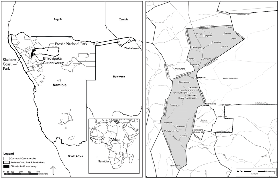
Fig. 14.1 Maps showing the positioning of Ehi-Rovipuka Conservancy adjacent to the western boundary of Etosha National Park. © Arthur Hoole, 2008, CC BY-NC-ND 4.0.
This chapter draws on PhD research carried out by first author Arthur Hoole in 2006 and 2007,2 brought together and edited by Sian Sullivan. Our aim is to provide historical depth for the context of Ehi-Rovipuka Conservancy and the implications of being park-adjacent for ovaHerero pastoralists now living there. The chapter draws on data generated through a suite of participatory research methodologies, including: “memory mapping” to document past associations with, and mobilities through, the wider landscape (Section 14.2); a structured survey concerning experiences of living adjacent to the park (Section 14.3); and documented local knowledge of wildlife in the wider region in relation to its relevance for conservation activities today (Section 14.4). Although this research was carried out some years ago, circumstances in Ehi-Rovipuka have changed little. The conservancy remains along the border of a national park, and peoples’ histories of utilising, moving through, being born, and desiring to be buried in the western reaches of the park, continue to exist. The chapter closes with a short conclusion (Section 14.5) reflecting on the implications of the findings shared here and on future possibilities for Ehi-Rovipuka as it looks westwards towards the Ombonde People’s Landscape initiative, as also discussed in Chapters 3 and 19.
14.2 Memory mapping with ovaHerero elders in Ehi-Rovipuka
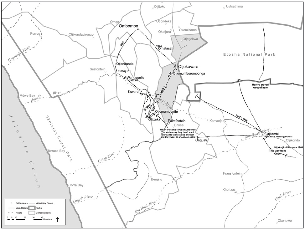
Fig. 14.2 Regional memory map drawn from the memories of Langman Muzuma, Festus Kaijao Vejorerako and Fanwell Ndjiva. © Arthur Hoole, 2008, CC BY-NC-ND 4.0.
Complex, remembered histories of association with the western part of what is now ENP were traced via a “memory mapping” methodology with ovaHerero elders, in which maps of remembered historical mobilities through the landscape were drawn on maps of the area. The resultant maps were supplemented by interviews with the elders who prepared the maps. Figures 14.2 and 14.3 are memory maps prepared by three elders. The late Langman Muzuma was the headman in Otjokavare (formerly Kowares) at the time of the research. He was born inside the boundaries of what is now ENP at Otjovasandu in 1912. Festus Kaijao Vejorerako, was born near Ombombo, outside the present-day park, and is the half-brother of both the former headman Kephas Muzuma and the present headman Langman Muzuma. Fanwell Ndjiva was also born at Ombombo, in 1941, and is a councillor with the Traditional Authority with jurisdiction at Ehi-Rovipuka (the Vita Thom Traditional Authority3). These three elders were 95, 80 and 66 years of age respectively at the time of the research. Memory maps4 were prepared by the elders with the assistance of Asser Ujaha (see Chapter 3), now also a board member for Namibia’s Game Products Trust Fund.5 These maps show routes that members of the community followed with their cattle between grazing posts and villages during two periods: circa 1907–1908 to 1928–1929 and circa 1967 to 1974 (Figure 14.2). They also include places inside the present-day ENP that the elders remembered, such as birthplaces and grave sites of persons they recalled (Figure 14.3) (see also Chapters 6, 12, 13 and 15 for similar mobilities and memories for other inhabitants of Etosha-Kunene).
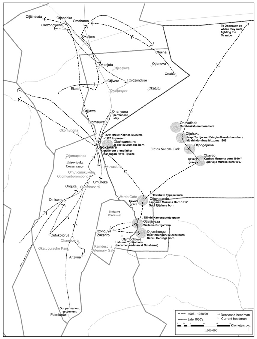
Fig. 14.3 Memory map detailing key places and mobilities in western Etosha, made with Langman Muzuma, Festus Kaijao Vejorerako and Fanwell Ndjiva on 13.8.2007. © Arthur Hoole, 2008, also published in Hoole and Berkes (2010: 310), CC BY-NC-ND 4.0.
Concurrent with these maps being prepared, Festus Kaijao Vejorerako was interviewed alone and then together with Fanwell Ndijva. The headman, Langman Muzuma, was also interviewed on a separate occasion. These interviews forming the basis of Section 14.2.1 were essentially story-telling by the elders in otjiHerero. They were translated as spoken by Asser Ujaha mentioned above, and recorded in handwriting. No attempt has been made to edit these narratives for tense or sentence construction.
14.2.1 A Story of the Hereros in Etosha
A full narrative of ovaHerero history in western Etosha related by elders now living in Ehi-Rovipuka Conservancy is shared here, and should be read together with the “memory maps” distilling key events and mobilities comprising this narrative (Figures 14.2 and 14.3).
Festus Kaijao Vejorerako (alone in first meeting, 24.4.2007)
Etosha is a place of my families. My grandfather and grandmother were born there; also my father and my mother. My older brother, Kephas Muzuma, former headman, was born at Okavao and Langman Muzuma, the present headman, was born at Otjovasandu [for the locations of these places see Figures 14.1, 14.2 and 14.3]. During that time the headmen had some power to control the area but the Hereros were killed by the Germans and we were split up as families and not too many were left [see Chapter 1]. We were chased out of the park when the whites came from Angola to settle on farmlands in 1928–1929.6 The South African Administration pushed us out.
Some of the headmen from other settlements today also lived inside the park. It was all Herero land. The Bushmen and the Herero lived inside the park. The Herero had their cattle there and the Bushmen killed our livestock if they couldn’t get enough wild animals. The Herero planted maize and the Bushmen did not.
We moved from the places in the park in 1928–1929 to Ombombo [in Kaokoveld]. My parents and others first went to see if Ombombo would be a good place and I was born there in 1927. We moved back to Otjokavare when the whites moved out in 19697 [from the farm Kowares]. We moved up to where we are today. Our headman (Kephas Muzuma) was rich and had lots of cattle at Ombombo. More cattle were being born and he decided to come back to settle where he was born at Okavao [in the western part of ENP]. He asked permission from the South African Administration and at that time this was a land of wildlife and at that time he was not allowed to go inside the park. When we came back some whitemen cattle were still here but officials said it was not healthy for the cattle to mix [also see ǂNūkhoe narratives in Chapter 13 regarding similar experiences].
Festus Kaijao Vejorerako and Fanwell Ndjiva (meeting on 27.4.2007, Festus spoke briefly at the beginning of this second meeting and then remained silent as Fanwell Ndjiva picked up the story)
From 1929 up to now he stayed where his brothers were in Ombombo. The people were told they must move away as the area was given to whites from Angola to move in there. An advanced party went to Ombombo in 1927 and found natural springs there. My parents were part of this group and he was born in that area in 1927.
The people had moved into the park area in 1907–1908 from the south, provoked by the Herero/German war and his parents were caught up in the fighting [see Chapter 6]. People escaped from the Omaruru area to Outjo and west to Onguati (Figure 14.2). They spread out from cattle posts between Outjo and Kamanjab. From there they moved north into Kaross and the west part of the park area.
Fanwell Ndjiva then speaks and tells the rest of the story.
My mother and father gave birth of me on the west side of the Ombombo area in 1941 on July 4. As a boy I started herding goats and sheep. At age 18 my father takes me to herd cattle. In 1967, the former headman, Kephas Muzuma, part of my father’s family, was a rich man and took our cattle and his together. I stayed close with Kephas Muzuma while I herded—he was born in the park. His parents were chased out by the South African government because the area was given to settlers coming from Angola and South Africa. The South African administration pushed people out of the Okavao area making way for the whites to come but they didn’t really settle in this area as there were not enough of them.
In 1967 we moved from Ombombo to the area by Sesfontein and Warmquelle. The South African governor came to Warmquelle and told the headman that our cattle are not healthy and that we cannot move across the Hoanib River—next to the big mountain [?Urubao] people cannot move cattle. Langman Muzuma stayed at Otjondeka and could not move his cattle. Over a certain line he could not go below it in the area between Otjivero and Warmquelle he couldn’t go south of that.
When this news came to Kephas Muzuma, who was head of all the headmen of Kaokoland, he went to Opuwo to meet the South West African Administration Governor, who was a white man. Before Kephas Muzuma met with the governor he called to all the communities of Kaokoland and told them that they chased me away from the land that I am born in and they wanted to bring in Angolans and South Africans. He felt they had enough land south of the park to farm on. Now I want to go back to the place where I was born but my cattle are said to be not healthy enough and my cattles’ blood must be tested so that I can go back where I was born. The area I am born in will now be in Etosha National Park. This is the message that he wanted to take to the governor in Opuwo—that he wanted to move back there where I came from.
At the meeting with communities some people disagreed with Kephas Muzuma to take his cattle for blood tests to go back to where he was born to finish his life there. Some herders went south of the Hoanib River and moved south to Otjomumbonde before the blood testing was done. When they came to Otjomumbonde there was a white person farming in the area who saw the cattle and told the governor at Opuwo about the cattle. Kephas Muzuma was in Windhoek at this time and when he received this message from the South African governor he refused to move the cattle. He said the South African government can go and shoot the cattle and you will pay for the blood of those cattles. In 1969 this happened. Fanwell was a herder with these cattles and they were shamed to hear this news so they took the cattle and went back to the area of Warmquelle.
In 1969 when Kephas Muzuma came back from Windhoek the cattle were already back in the Warmquelle area. He asked why the cattle had not been left there and said to take them back so that the whites could come and shoot them if they want—we will bring more and start another herd. Kephas Muzuma really wanted to occupy this area. They took cattle back but only ones not breeding at the time and left others behind. Kephas Muzuma came to the herders again, including Fanwell, and told them to go and investigate places with enough water for our cattle and they went to Onguta, Otjomumborombonga and Otjokavare in 1970.
[At this point it was asked why Kephas Muzuma did not direct them to go back Okavao.]
Fanwell Ndjiva continued:
There was no spring there—in old times dry for water. The distance was too far so we go step by step. This whole area was part of the park in those days and larger than now [see Chapter 2]. They did eventually want to get back to the area where Kephas Muzuma was born. They needed an area with springs to water the cattle.
In 1970 the government drilled a borehole at Ohanjuna and didn’t use it. Kephas Muzuma went to the government to put a pump there for the cattle and the government did that and 2,000 oxen went to Ohanjuna [north of Otjokavare/Kowares].
In 1970, the MET [Ministry of Environment and Tourism8] shot your dogs sleeping right next to you because they were in part of the park and the dogs could catch wildlife. You could not have a gun, or a bow and arrow.
Kephas Muzuma’s permanent house was at Ombombo but he moved around to visit the cattle posts because he was the chief of all. This place was in the middle of all and he was the chief of all. In 1975, after cattle is settled more people moved south with their cattle and Kephas Muzuma brought his holy fire to Otjokavare to settle permanently here.
The park fence was built—a survey was done in 1972. At that time the Hereros disagreed with the fence and reported this to the chief of the Hereros. They took cattle across the survey line to test ground minerals. The government caught Kephas Muzuma and put him in custody at Kamanjab.
When Kephas Muzuma was at Otjokavare he asked the government to go back into the park and they said no. The government gave grazing rights north of the Ombonde River and south of Hobatere. Headman Muzuma met with the chief of the Damara [Gaob Justus ǁGaroëb, see Chapter 13] and traded the grazing area to the Damara for the area south of the Ombonde River to Palmfontein.
Kephas Muzuma said to the South African government that he could not die with a good heart without returning to his birthplace inside Etosha. In 1980, there was a big drought and Kephas Muzuma ordered his people to cut the park fence and let cattle into the park. People from the MET asked who cut the fence and Kephas Muzuma said it was him. Another delegation came from Windhoek and asked Kephas Muzuma, if we give you minerals, salt and grass for your cattle will you stop cutting the fence? Kephas Muzuma said yes and there was no more cutting of the fence.
Kephas Muzuma died and was buried at Otjokavare in July 2001, next to the road. A lot of chiefs come and say he is very brave and must bury him where all brave people are buried. But we buried him in an area taken by force by the South African government and everyone can see it from all directions—the owner of this area.
14.2.2 Interpreting the elders’ stories and memory maps
The stories told by the elders, and the maps they produced of their memories and reflections, provide evidence of local residents being displaced from a national park and becoming decoupled from resources they had used and formed dependant relationships with. The stories tell of how ovaHerero people occupied and used the western part of present-day ENP from at least around 1908 until the late 1920s. Members of the Ehi-Rovipuka community today are part of this history, including two of the elders who participated in the story telling and mapping. Festus Kaijao Vejorerako also stated that his grandparents and parents were born in the park area, suggesting that ovaHerero people perhaps lived in the park area prior to moving into central Namibia, and that their descendants may have returned to the park area during the colonial war of 1904–1908 (see Chapter 1). The elders reported that their families moved back into the western part of Etosha at the end of the war (as shown on Figure 14.2), as part of the ovaHerero diaspora that resulted from the German genocide. The elders indicated a north-south line in the western part of Etosha (Figure 14.2) that ovaHerero stayed west of. This sense of ovaHerero territory in Etosha exists alongside other inhabitants of the land that is now ENP. Haiǁom Bushmen were concentrated to the south and east of Etosha Pan (see Chapters 4, 15 and 16). Historical records also report that mobilities of “Bergdamara” (ǂNūkhoen) included the area west of Etosha Pan,9 and Owambo herders are documented as utilising areas such as Namutoni to provide water and grazing for large herds of cattle10 (see Chapter 1).
An especially significant revelation from the stories recounted in Section 14.2.1 is the reason given for displacement of ovaHerero from present day ENP: specifically, that people were ‘chased out of the park’ when white settlers came from Angola in 1928–1929. These settlers were the Trekboers who had left the Cape Colony in South Africa following legal changes effecting the liberation of enslaved workers; who then trekked northwards through the Kalahari and into the territory now known as Namibia, eventually settling in southern Angola in the late 19th century (as documented in Chapter 1). They were offered the opportunity to re-settle in Namibia by the former South West African Administration (SWAA), amidst the administration’s focus on amplifying the numbers of white South African farmers settled in the territory (see Chapter 2). In prioritising these white settler farmers, ovaHerero and others were summarily dispatched from landscapes west and south of Etosha, in the corresponding and iterative effort to establish a livestock free zone between the southern Police Zone and native livestock in the north (see Chapter 13, Figure 13.3). The ostensible aim was to prevent transmission of foot and mouth disease and lung disease from African cattle.11 In other words, it was the competition for place and space with colonial settlers that was the pretext for re-locating the ovaHerero from present day Etosha.
This fact is at odds with an underlying assumption that local residents were initially displaced by a national park conservation agenda. In fact, as the elders’ stories unfold further, we learn that ovaHerero were relocated to the Ombombo area, which at the time, was within Game Reserve No. 2 but simultaneously part of the Kaokoveld Native Reserve, established in 1947 (see Chapter 2). OvaHerero were not in fact removed from the game reserve of the day, but were relocated to a more remote part of it, away from a place and space intended for colonial farm settlement and cattle production. The concern about African cattle mixing with colonial farm cattle runs throughout the story in Section 14.2.1. It explains why the intended return to former grazing territories led by headman Kephas Muzuma in the 1960s was spurned by the South African administration.
A clear theme in the elders’ stories and their mapping is indeed Kephas Muzuma’s vision to return his people to the place of his birth at Okavao, around 30 kms south-east of Otjokavare in the west of ENP (see Figures 14.1, 14.2 and 14.3). Kephas Muzuma was born at Okavao in 1910 and lived in the park area until being forced out as a young man with his parents in 1928–1929, when they moved north-west to Ombombo, beyond the present-day park boundaries. He had come to know the western part of Etosha National Park as his home and he never forgot the area. His father, Kamuhona Muzuma was headman at that time, and in 1946 Kephas succeeded his father as chief.12
A strong sense of place emerges from the movements of people and the various sites depicted. For example, four cattle posts located in a north-west alignment inside the western part of the park carry particularly evocative names (see Figure 14.3). Onavatinda means the family place of the family named Tinda and Otjuhaka means the place of the beasts (cattle) with white stomachs and hooves. Otjongejama is the place of lions and Okavao—birthplace of Kephas Muzuma—is the place of the shield. Further to the south, Otjovasandu is the place of young men and a perennial spring made it an outpost for watering cattle in the winter months. The presence of lion, rhino and elephants required the fittest and most fearless young men to protect the cattle.13 Otjatjiweza is the place of the family Tjiweza and Otjomirungu is a place of meeting and people coming together. Otjimbokowe is a rocky place used as a refuge during fighting. Okawamburo is a place of the small spring and Otjokavare is the place of small palms and much water. Onaruwondo is the place of small round houses. These ovaHerero names are thus full of references to families, cattle, wild animals, water sources, vegetation, and terrain, all meaningful elements in the cultural life that took place in western Etosha (for more on placenames and meanings across the cultural diversity of the Etosha-Kunene area see Chapters 6, 12, 13 and 15).
Kephas Muzuma’s desire to move back to the park area in the late 1960s was ultimately denied. When his advance parties reached present-day Otjokavare they were frustrated by the South African administration in their attempts to move into the park area. Soon afterwards the park fences were built and efforts to move cattle back into prior grazing areas were met with denials by the government and the temporary imprisonment of Kephas Muzuma when he directed his people to defy the park fence line. At his death in 2001 his followers deliberately chose to bury him as close to the park boundary as possible, and other interviews indicated a wish to move the former headman’s bones back to his birthplace Okavao, now inside the park. There is clearly a lingering desire for the present Ehi-Rovipuka Conservancy area to be reconnected with pastures, ancestral territory and cultural heritage inside the park. Instead, the conservancy remains split from former pastures, the park fence running along its long eastern boundary rendering this artificial demarcation both visible and more-or-less impassable.
14.3 What is it like to live next to Etosha National Park?
It was only with the evolution of a park conservation agenda following the Second World War and the fencing of Etosha in the early 1970s (as outlined in Chapter 2) that ovaHerero were denied access to the newly delineated park area specifically for wildlife conservation reasons. Until that time, and similarly to the experience of Haiǁom (see Chapters 4, 15 and 16), wildlife harvesting by ovaHerero had been tolerated in the historical game reserve areas, even though official legislation may have suggested otherwise. This situation correlates well with responses to a question posed in villager interviews enquiring about how peoples’ ancestors may have utilised wildlife inside the park. In this section experiences of living next to the park boundary are recounted and analysed, drawing on a structured survey with 40 villagers in Otjokavare. The respondents included representatives from 19 extended family households, as well as village elders, community game guards (CGGs), school teachers, pupils and villagers employed by the conservancy. An effort was made to interview both men and women: of the 40 participants, 22 were male and 18 were female. This survey featured a series of questions, some of which are included in Table 14.1, that aimed to understand present-day relationships between the community and the park.
Table 14.1. Survey questions regarding experiences of living next to Etosha National Park asked to 40 respondents living in Otjokavare, Ehi-Rovipuka.
A fundamental first question asked to villagers was ‘what is it like to live next to the park’? Responses to this question are summarised in Table 14.2. They indicate a high affinity with the elders’ story-telling and mapping recounted in Section 14.2. Most respondents (55%) reported the story of people being chased from the park and the desire to return to the birthplaces of their ancestors inside the park. Almost a third (30%) referred to following their headman back to his birthplace, but being stopped by the park formation and fencing. Most of the remaining responses referred to frustrations dealing with denial of access to grazing and water in the park. A significant number (25%) noted the value of the park for seeing animals and for educating learners (pupils), mostly from school teachers and pupils. Virtually all respondents (98%) indicated their ancestors had lived in ENP. In shorter interviews with a few people from other villages in the conservancy, as well as with school students interviewed from other communities, all respondents from other communities in Ehi-Rovipuka Conservancy indicated they had ancestors who had lived in ENP.
In terms of wildlife use, most of the villagers’ responses (65%) indicated their ancestors within the present area of the park utilised the same animals they use today outside the park for meat. A further 23% of responses indicated that their ancestors had hunted animals inside the park for meat, skins and animal parts, while several noted some species they cannot find outside the park today that were hunted by ancestors inside the park, such as red hartebeest (Alcelaphus buselaphus caama) and blue wildebeest (Connochaetes taurinus). A few interviewees also mentioned the gathering of field foods inside the park by their ancestors. At this time, the vast and remote Kaokoveld region was patrolled by only a handful of personnel, mitigating against indigenous wildlife use being denied or penalised by the government. Firearms were not widely used by ovaHerero during this time, and any harvested wildlife was for subsistence use in association with semi-nomadic pastoralism. These various factors explain why ovaHerero use of wildlife remained largely uninterrupted by the early colonial administration.
Table 14.2. Experiences of living next to Etosha National Park.
When asked what people do in the park today, the vast majority (83%) said that they did ‘nothing’. The remainder noted that some villagers had obtained jobs in the park. Two comments were particularly illustrative, namely ‘we cannot even bury our dead there any more’, and ‘the fence defines the relationship. We cannot go past it’. When asked what benefits are received from ENP today, 35 of the 40 villagers interviewed (88%) indicated no benefits were received and 10% noted that jobs were provided by the park. Meat supply, conservation, translocation of animals, and the protection of villagers from predators each received only one or two mentions. One quote is especially illustrative, corresponding with responses analysed in Chapter 5:
[t]he colonial system gave a lot of pain. We had hoped with the new government after Independence that we might get some rights but nothing has come. We are still crying from the past until now.
A final park-related question asked villagers what benefits they would like to receive from ENP. The most frequent reply was a desire for grazing rights, especially for emergency grazing (62.5%) during drought, followed by involvement in joint tourism development ventures inside the park (47.5%). A variety of other potential benefits were identified (Figure 14.4), including re-settlement in traditional areas, fences to protect the school hostel and yard in Otjokavare, the ability to visit traditional areas and burial areas inside the park and the translocation of some park animals for community use and revenue generation. Some villagers suggested removing the park fence to allow animals and people to move freely, and to permit the harvest of field foods and medicinal plants inside the park, as in the past; fewer responses also mentioned jobs, meat sharing, safe transport for learners to school, and burials in the park with ancestors.
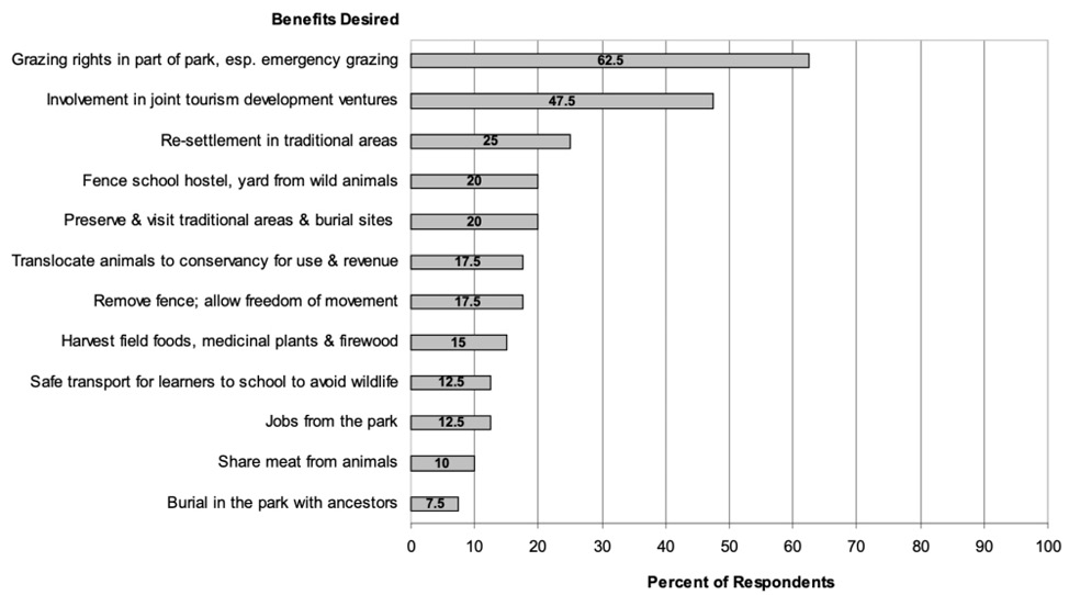
Fig. 14.4 Benefits villagers interviewed at Otjokavare, Ehi-Rovipuka Conservancy, would like to receive from Etosha National Park (n = 40). © Arthur Hoole, 2008, CC BY-NC-ND 4.0.
14.4 Local knowledge of wildlife in the wider region and its relevance for conservation activities today
In this section, villager attitudes towards and perceptions of wildlife at the time of this research are recounted, as well as their understanding and experience with the conservancy institution itself. The results of structured interviews, community mapping processes and key informant interviews are presented to create a picture of the place of the community in community-based wildlife conservation. Related details are elaborated for community wildlife monitoring and census processes (Section 14.4.1), as well as governance and administrative organisation features, to provide additional context for understanding and interpreting overall findings. Summary reflections are offered, including further reference to a potential model of attributes for successful community-based conservation.
14.4.1 Wildlife monitoring in Ehi-Rovipuka
Part of the community-based research aimed to better understand community attitudes and perceptions towards wildlife and conservation. At the time of this study, the literature on CBNRM and the conservancies in Namibia was replete with the success of conservancies restoring wildlife populations and producing significant national and community benefits from wildlife in terms of conservancy revenues and employment.14 It should be noted that this period also coincided with a run of very good rain years (for more on wildlife population dynamics in the north-west see Chapter 3). In this section villager attitudes towards wildlife are documented, as a basis for evaluating the robustness of conservancies as institutions for wildlife conservation, as well as the prospects for biodiversity conservation linkages with protected area management. The community-based wildlife census process at the time of study is briefly described, as a precursor to findings about community wildlife values and attitudes. Considerable importance and staff resources are attached to this wildlife monitoring process by the conservancy and the national CBNRM system. The monitoring of wildlife populations and the development of trend data rest at the heart of conservancy conservation activities.
At the time of this research, conservancies—in cooperation with national conservation NGOs and MET personnel—conducted annual game censuses each June. The monitoring process is community-based, led by the CGGs, with technical support. For Ehi-Rovipuka Conservancy specifically, a vehicle-based road count is made along five different routes in the conservancy. The average strip width of these routes is 0.32 km and the area represented by the different route zones is approximately 1,417 km2. Areas of mountainous or rough terrain are excluded in the preparation of population estimates and in the case of Ehi-rovipuka, this area is about 28% of the overall conservancy area, or 562 km2. Thus, the population numbers derived are underestimated for the overall conservancy area and are considered conservative by the agencies involved, building in a safety factor when offtake quotas are ultimately set; although as described below the observed numbers of animals are corrected upwards to take account of land areas missing from the surveys.
Once animals are counted along a strip route, the length and width of the strip route are used to calculate the strip area. It is then estimated how many times the strip area “fits” within the route zone area it transects. The actual number of animals counted is then “corrected”, i.e. multiplied by this factor of the number of strip areas that can fit within the zone, leading ultimately to the amplified regional population estimates shown in Figure 14.5. Resultant route zone estimates are further refined by information from other monitoring methods such as foot patrols by CGGs, specialist species studies conducted from time to time, and local knowledge, to arrive at a consensus for the annual population estimate. Further modelling and adjustments to animal estimates are carried out by a natural resources working group in Windhoek, and contributes to the annual quota setting process with the then MET.15
These data show that population trends vary from species to species, as well as from local levels (i.e. Ehi-Rovipuka) to regional level, primarily attributable to varying movement patterns for different species. For Ehi-Rovipuka in the surveyed years, gemsbok (Oryx gazella) populations remained relatively stable, with 900 estimated in 2002 and 882 in 2006. For giraffe (Giraffa camelopardalis angolensis), the conservancy estimated the population increased, from 100 in 2002 to 382 in 2006 (see Chapter 9). For springbok (Antidorcas marsupialis), the estimated population also grew from 700 in 2002 to 914 in 2006. There was an inexplicably high number of 7,951 reported for Ehi-Rovipuka’s springbok population in 2005, possibly due to the wide movements of animals and unknown field changes in sampling method and intensity.16 For Hartmann’s mountain zebra (Equus zebra hartmannae), estimates remained relatively stable, with 150 in 2002 and 131 in 2006. Note that these population increases in the good rain years prior to 2011 need to be seen in the context of subsequent declines in following years, as documented in Chapter 3.
Ehi-Rovipuka Conservancy’s boundaries represent the area in which the conservancy has recognised authority to manage wildlife and derive benefits from the wildlife resource. Registered members of the conservancy share in the benefits that may be derived from wildlife, and its boundaries are intended to exclude anyone else from use of the conservancy’s wildlife. The conservancy is responsible for the monitoring of populations as illustrated above. Based on the wildlife numbers resulting from the annual censuses, the conservancy makes a request for annual quotas to the MET (now Ministry of Environment, Forestry and Tourism, MEFT). The ministry reviews the census results with a technical group of supporting conservation NGOs and, towards the end of each calendar year, grants annual offtake quotas to the conservancy based on this process. The ministry also sets a five-year quota framework for the conservancy.
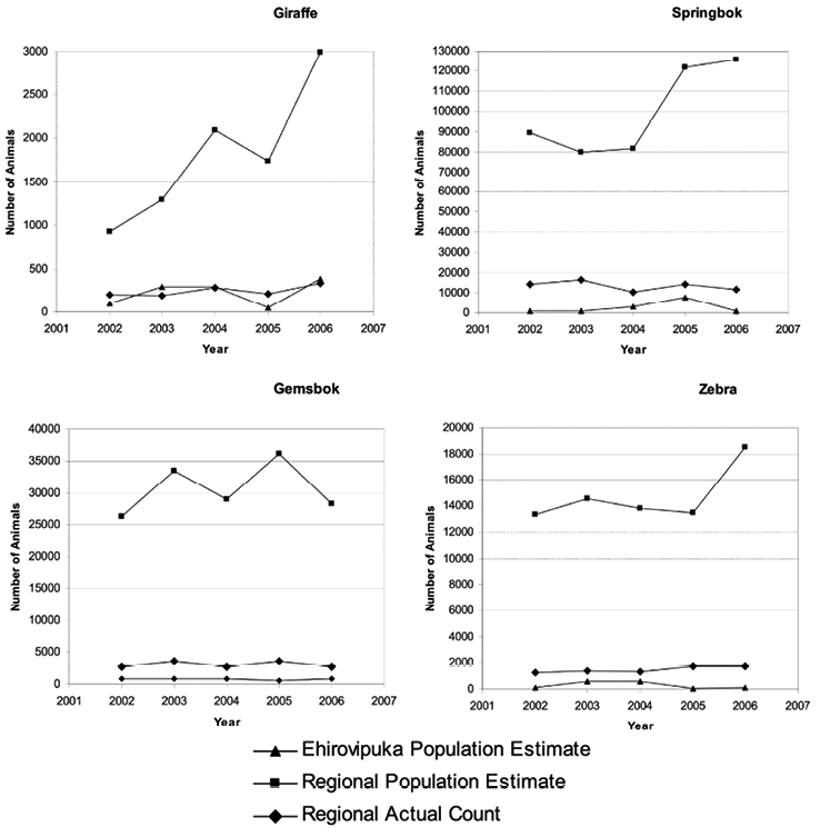
Fig. 14.5 Regional and Ehi-Rovipuka Wildlife Census Data from 2002 to 2006. Adapted from: CONINFO Information System 2006. © Arthur Hoole, 2008, CC BY-NC-ND 4.0.
14.4.2 Community Perceptions of Wildlife and Conservation
Turning now to attitudes and values villagers place on wildlife, a series of questions were posed to probe these topics: as shared in Table 14.3.
Table 14.3. Survey questions regarding experiences of living with wildlife asked to 40 respondents living in Otjokavare, Ehi-Rovipuka.
The first question inquired about the importance of wildlife to household life. The question was closed-ended, and asked respondents to select one of three possible choices—wildlife is ‘important’; ‘somewhat important’; or ‘unimportant’. Respondents effectively changed this range of possible responses, totally avoiding the ‘somewhat important’ choice and adding another response—‘very important’: see Figure 14.6.
Villagers gave a variety of reasons about why wildlife is important to them, as shown in Figure 14.7. Most interviewees (60%) indicated that meat from wildlife was the reason for its importance to households. A closely related factor was the importance of wildlife for livelihoods and survival. The inherent beauty of wildlife, as well as its role in generating revenues for community projects, was also important: from a utilitarian perspective, the ranking of appearance and characteristics of animals ahead of benefits derived from wildlife was somewhat surprising. Villagers were additionally asked which wild animals they liked or disliked, and the reasons for their preferences (Figures 14.8 and 14.9). It is mainly the herbivores that were favoured, although 28% of the respondents indicated that they liked all wildlife. A few other species were mentioned only once as being liked by respondents, including warthog (Phacochoerus africanus), hares (Lepus capensis), leopard (Panthera pardus), rhino (Diceros bicornis bicornis) and mopane worms (edible caterpillars from the emperor moth Gonimbrasia belina).
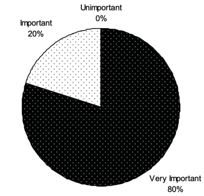
Fig. 14.6 Importance ratings of wildlife to community households in Ehi-Rovipuka Conservancy (n = 40). © Arthur Hoole, 2008, CC BY-NC-ND 4.0.
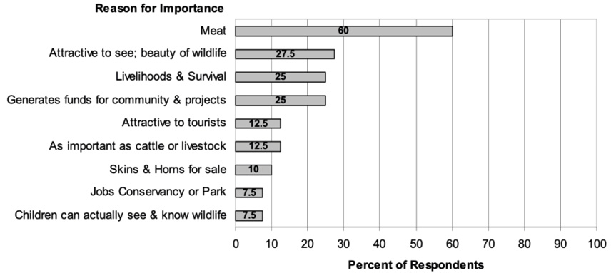
Fig. 14.7 Graph showing reasons given for wildlife importance (n = 40). © Arthur Hoole, 2008, CC BY-NC-ND 4.0.
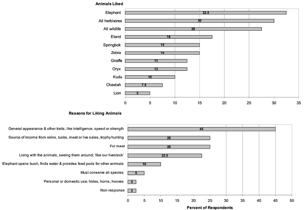
Fig. 14.8 Graph showing wild animals that are liked by villagers (above) and stated reasons for their preferences (below). © Arthur Hoole, 2008, CC BY-NC-ND 4.0.
The wild animals that are disliked are mainly the predators (Figure 14.9), with 40% of the villager respondents noting they disliked all predators. Lions (Panthera leo) were specifically disliked more than any other individual species, followed by elephant (Loxodonta africana). The reasons given for disliking wild animals predictably centred on danger to humans (52.5%), livestock destruction (45%) and loss of property (32.5%). Indeed, the antipathy towards predators is noteworthy (see Chapter 8).
While not unexpected in terms of perceived and real threats posed by predators, this finding may have implications for accounting for the role of predators in overall ecosystems function and as animals of particular interest and attraction in wildlife viewing by tourists (as discussed more fully for lions in Chapters 17, 18 and 19). It was also interesting to note the ambivalence towards elephant. Almost a third of the respondents identified elephant as an animal they liked whilst 17.5% indicated they disliked elephant. This finding is at odds with some of the human-wildlife conflict (HWC) literature in Namibia that suggests elephants are only a problem for communities (also see Chapter 11). Perhaps inherent traits of elephant such as their dominant size, intelligence, as well as their ecological roles in creating habitats and water sources for other wildlife, explain their relatively high ranking as an animal appreciated by villagers.
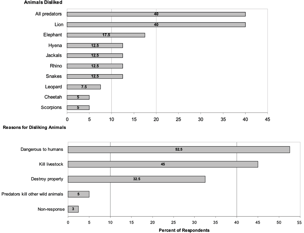
Fig. 14.9 Graph showing wild animals disliked by villagers (above) and the reasons given for their dislike (below). © Arthur Hoole, 2008, CC BY-NC-ND 4.0.
Villagers were additionally asked what causes increases and decreases in the numbers of wild animals. The vast majority (78%) identified rainfall as the main cause of increases, along with conservation practices including the control of hunting, conservancies and parks, monetary rewards, CGGs and monitoring (53%). Natural reproduction was mentioned once. Decreases were largely attributed to drought (85%) and uncontrolled hunting/poaching (33%). Predation, uncontrolled settlement, translocations of animals like black rhino away from the conservancy, and trophy hunting of prime male animals, were each mentioned once or twice as other factors causing decreases. Overall, villager responses show the prevailing role of reliable rainfalls and drought as principal determinants of wildlife numbers.17
Another topic related to problem animals. Villagers were asked how their ancestors had protected their livestock from wild animals, the results of which are summarised in Table 14.4. Responses reveal important differences in past practices from the more sedentary contemporary community life. Most respondents (73%) identified that herders stayed with the livestock and brought them into kraals at night in the past. Other responses emphasised a more active knowledge of predators by the ancestors that helped protect livestock.
Table 14.4. Methods employed by ancestors to protect livestock from wild animals (n = 40).
The following comments made by some villagers further capture the essence of the contrasts between present day care of livestock with past practices:
- ‘Today, no one herds the cattle. They are sent out on their own and the children are in school’;
- ‘Well, you can see, the people are just sitting around here in the village and the cattle move out into the fields by themselves’;
- ‘When there were problems with cheetah, they would take the calf of a donkey and put it in the kraals with the goats so that when the cheetah came, the mother donkey would make a lot of noise to protect her calf’.
14.4.3 Local knowledge of wildlife
Several other methods were employed in the community-based field research to further illuminate community perceptions and knowledge of wildlife. Local knowledge maps for seasonal wildlife distributions and poaching/problem wildlife incidents were prepared by three knowledgeable villagers engaged in wildlife management responsibilities with Ehi-Rovipuka Conservancy (Figure 14.10). This documentation included how these incidents had changed from the start-up of Ehi-Rovipuka Conservancy in 2001–2002 to the time of the research several years later. Notwithstanding the variability in individual mapping details, all maps display some common patterns of species occurrence. For example, springbok are consistently shown as dominant in the north part of the conservancy. This is a more open, less rugged area, consistent with preferred habitat conditions for springbok. Areas where lions are best seen are consistently shown along the south-east side of the conservancy. These observations are consistent with the findings of a study in these years reporting four lion prides living in western ENP, with two prides regularly breaking through the park boundary fence.18
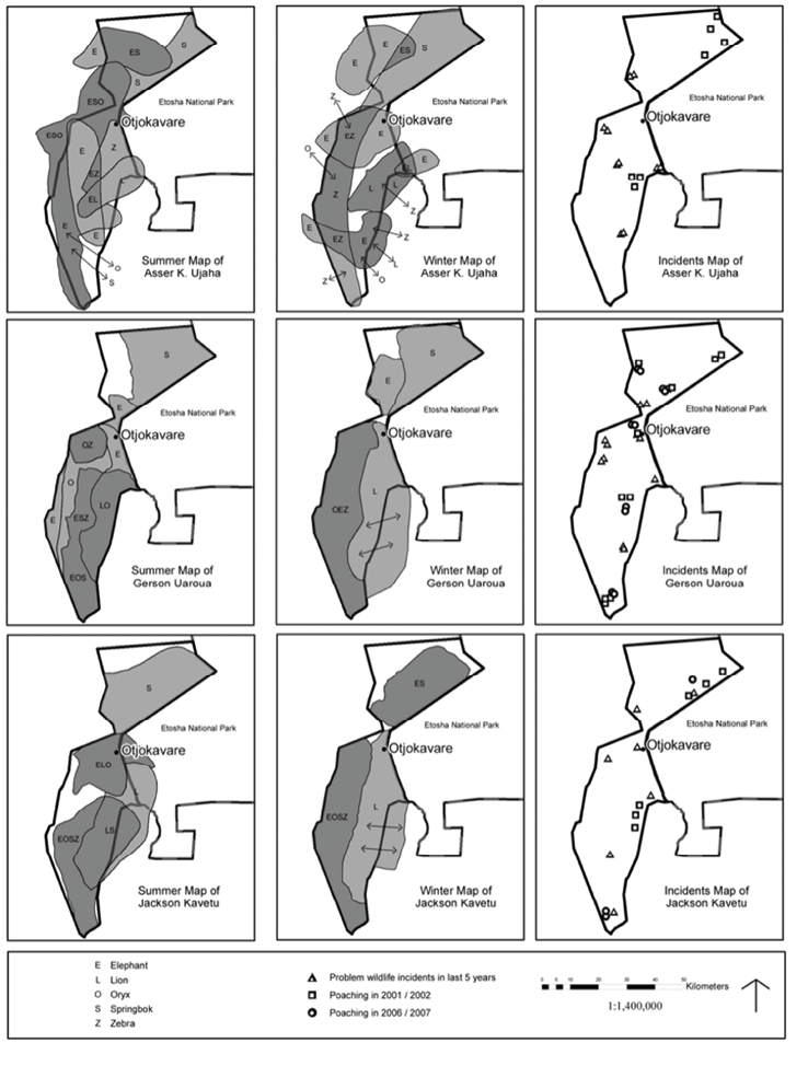
Fig. 14.10 Maps illustrating local knowledge of wildlife distributions in Ehi-Rovipuka Conservancy. © Arthur Hoole, 2008, CC BY-NC-ND 4.0.
These three participants were also invited to draw regional wildlife distribution maps for five species, as shown in the map legends (Figures 14.10 and 14.11). Brief mapping instructions were provided to the participants for the symbols and colours to be used to distinguish species, two different seasons, and the point data of wildlife incidents. Participants were asked to show the best areas for seeing the different species for the two different seasons. Each participant received the mapping guidelines through the community field interpreter, who was one of the mapping participants himself: they completed the maps independently of the lead researcher and of each other, following which we met as a group to verify the maps. The resultant maps display considerable variability in level of detail and no attempt was made to reconcile these differences. It was evident in the group discussion and verification session that each participant had paid different attention to details, especially in the regional wildlife distribution maps. It was also acknowledged by participants that Asser Ujaha’s maps of wildlife distributions were the most detailed and the others did not contest those additional details.
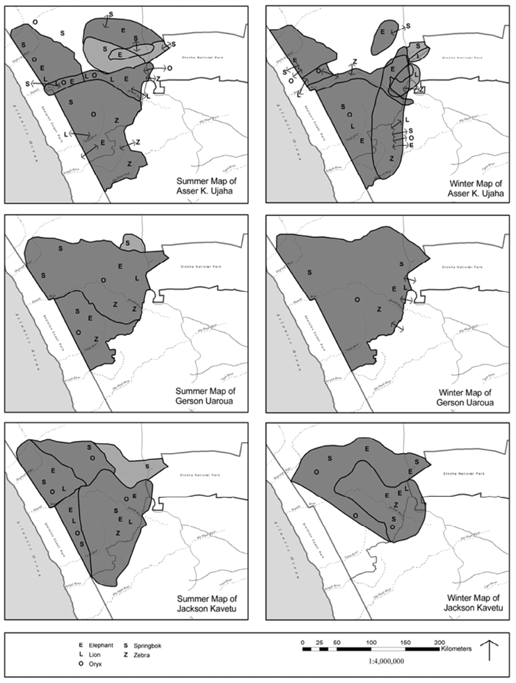
Fig. 14.11 Maps illustrating local knowledge of regional wildlife seasonal distributions by members of Ehi-Rovipuka Conservancy. © Arthur Hoole, 2008, CC BY-NC-ND 4.0.
Changes in seasonal distributions of wildlife from summer to winter seasons are detectable at the conservancy level (Figure 14.11). This is evident for lion, with greater movement and dispersal in the dry winter period compared to the wetter summer period. Dispersal changes are also evident for elephant. Springbok reverse the usual pattern of more species dispersal during the summer rainy season. They concentrate on short green pastures during the rains and disperse into smaller herds during the dry season. This is evident in the local knowledge maps, especially those of Asser Ujaha.
Hartmann’s mountain zebra are predominantly shown in the south-west reaches of the conservancy area. This is more rugged upland country and local knowledge of this animal’s distribution is quite consistent with the western science description of the mountain zebra’s preferred habitat (see Chapter 10). Elephant seem to be seen periodically throughout most of the conservancy area, but greater concentrations are evident in winter months to the north. Considerable overlap of areas where the five different species are seen is also evident for the conservancy area, as well as lines of wildlife movement, especially in the winter months. The lines of movement depicted are all in the area of the conservancy south of Otjokavare. In Asser Ujaha’s winter map of the conservancy area, lines of movement roughly correspond with the Ombombe River corridor and associated tributaries. The regional maps of Asser Ujaha (Figure 14.11) illustrate the importance of the Hoanib River watershed for wildlife, another aspect of local knowledge consistent with conservation understandings of the area (also Chapters 3 and 13). Generalised patterns of greater species dispersal in summer, as compared to winter seasons, are also evident in the regional wildlife distribution maps. Some of the maps show some wildlife linkages to the western parts of ENP, but the predominant pattern that emerges is the barrier effect of the park fence that runs along the entire western boundary of the national park.
Problem wildlife incidents in the last 5 years (see Figure 14.10) include attacks on livestock by wildlife or damage to property such as community boreholes or crops. Poaching incidents refer to unauthorised harvests or use of wildlife. The data obtained from the community mapping process shows only a few poaching incidents, ranging from six to 10 in number for 2001–2002 and from zero to 10 in 2006–2007. Gerson Uaroua was one of the three mapping participants and at the time of study was also a senior community game guard for Ehi-Rovipuka Conservancy. He recalled more poaching incidents compared to the others. Regardless, the number of poaching incidents is low and the participants indicated that most were perpetrated by people from outside the conservancy villages. The number of sites shown for problem wildlife incidents in the last five years is relatively few. Hoole studied unpublished annual natural resource reports prepared by the CGGs for 2002 to 2005.19 The recorded number of poaching incidents correlated well with the local mapping results. Problem wildlife incidents in the field reports ranged from 145 to 279 livestock attacks per year, mainly by hyenas (Crocuta crocuta), lions, leopards, and to a lesser extent cheetahs (Acinonyx jubatus). Very few crop damage incidents were reported, but elephants were implicated in several instances of water borehole damage (see Chapter 11). A study of human-wildlife conflict in the Ehi-Rovipuka Conservancy found that spotted hyenas, leopards, cheetahs and lions caused the most problems (also see Chapters 17 and 19).20
It is possible that participants in the mapping processes may not have wanted to reveal poaching incidents, although the close rapport developed with at least two of the three mapping participants suggests otherwise. Also, observations at the time of the research of low densities of wildlife associated with the semi-arid character of the area, alongside the natural resource report data and a general absence of references to poaching in the community interviews, confirms that poaching at the time of the research was not significant. Human-wildlife conflict incidents are more significant, especially livestock attacks. Much is made in literature about human-wildlife conflicts, and this is a preoccupation in the management programmes in ENP and with some NGOs (also see Chapters 11, 17, 18 and 19). The data reported here, combined with results from the likes and dislikes of different wild animals indicated by villagers in Section 14.4.2 suggest that there are indeed conflicts with predators. Lions and elephant frequently break through the western boundary fence of ENP and these animals are implicated in complaints about livestock and property damage.21 The area warden for western Etosha also mapped recurring places of fence breaks by lion and elephant and these are shown in Figure 14.12.
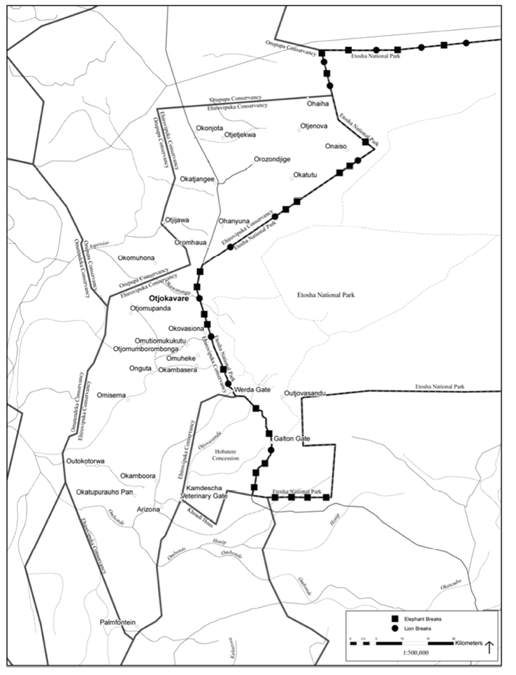
Fig. 14.12 Map showing recurring Etosha National Park fence break locations by elephant and lion, on the eastern boundary of Ehi-Rovipuka Conservancy. © Arthur Hoole, 2008, CC BY-NC-ND 4.0.
Villagers additionally confirmed that rules existed in the past regarding the utilisation of wildlife. These were made by the headman and were known by everyone. They included hunting only in the winter (well after the young had been born, during the earlier rainy season), which was also a time when it was cooler to keep meat fresh, and animals were fattened up. Hunters were not allowed to take females with calves—mainly male animals were taken—and females were not permitted to be hunted in the breeding season (see Chapters 12 and 15). Other rules mentioned were that animals could not be taken near water, hunting pressure would be reduced when numbers were depleted, and animals could only be hunted with the agreement of the household head. There was also a separation of hunting areas among different groups of hunters. Further enquiries were made about what happened when such community rules for using wildlife were not followed in the past. Many of the respondents indicated that there were no actions taken since people were on the move, they hunted with bows and arrows and could not kill a lot of animals. The headman was not nearby to enforce rules. A further 33% indicated they believed the headman and council would meet with reported violators, initially warn them and if there were repeat offences, fines in terms of payments to the headman in livestock would be made. Others noted that repeat offenders or those who could not pay fines in livestock would be beaten on the buttocks in public. Punishment was according to the seriousness of the deed. Many of the villagers interviewed did not know about what may have happened in the past when rules were broken, and did not know what the rules may have been.
An interesting exchange took place at the community report-back and verification meeting that encapsulates the dichotomy evident in villager awareness about past rules of use for wildlife. Preliminary findings were summarised that were similar to the descriptions above, but a young school teacher stated there were basically no rules for wildlife use before the conservancy, asserting that people hunted wildlife as they pleased. The headman was present, however, and he argued strenuously against the teacher’s comments, reiterating that there were indeed rules made by headmen in the past, and everyone knew these rules.
Manfred Hinz22 documents that rules for wildlife use in the past reflected an Indigenous conservation ethic and respect for wildlife. The social memory of those rules seems to have faded: while not evident in current conservancy institutional arrangements, a conservation ethic was undoubtedly a factor in the agreement of the headman and communities to institute the CGG programme and then form a conservancy. The wildlife laws of central government now prevail. Violators are reported to the MEFT or to the national police by CGGs or villagers at large, with a graduated system of fines and incarceration applied by the courts.
14.4.4 Field foods
Field foods and their importance to communities was an oversight in the structured villager interview questions, however, many villagers identified field food as important to their households in discussions, with field food harvest one of the benefits they would like to enjoy within and from ENP. One key informant quoted an old ovaHerero saying that: ‘if you don’t gather field fruits the rains will not come’. The importance of field foods was also stressed by Asser Ujaha, the community assistant and interpreter in this research. He described how mopane worms are harvested from March to May, boiled and dried in the sun, then bagged and sold in Oshakati. Mopane worms are both a dietary staple and can be used in treatment of blood pressure. Mopane (Colophospermum mopane) leaves are chewed to relieve stomach ailments and the dung of mopane worms is used to heal wounds. He further described the use of Devil’s Claw (Harpagophytum procumbens) as a malarial fever treatment and pointed out trees harvested for various fruits near Otjokavare.
He also noted the harvest of wild honey in July and August by people in Otjetjekwa, in the north part of the conservancy. Bees are smoked out of tree hives and the honeycombs removed.23 Apparently, this practice has produced veld fires and there are government sponsored workshops to train how to safely harvest without killing the bees and starting fires. Asser Ujaha also related that smaller animals like rock dassie (Procavia capensis), porcupine (Hystrix africaeaustralis), and birds like wild dove, kori bustard (Ardeotis kori) and guineafowl (Numida meleagris) are used. Technically, some of these species are subject to government harvest regulation through quotas, but such harvest appears to be largely unregulated and is not high at any given time. Other villagers indicated that the low return of meat from the harvest of birds and smaller game does not warrant the effort to hunt or trap them intensively and therefore such use is more incidental.
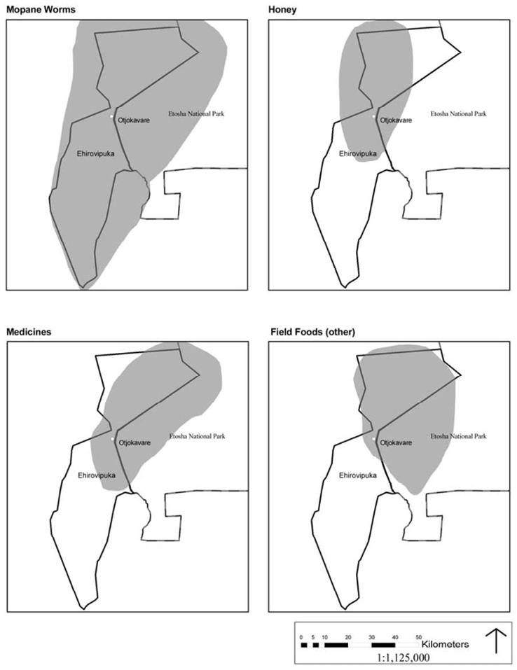
Fig. 14.13 Combined field food and medicinal plant distribution maps of three women village harvesters: Sylvia Kavetu, Rosana Kavetu and Naangota Mavongara. © Arthur Hoole, 2008, CC BY-NC-ND 4.0.
Given the apparent overall importance of field foods,24 a mapping exercise was carried out with three village women in which they were asked to map important areas for field foods (see Figure 14.13). Women were invited to prepare the maps because women play the main role in harvesting most field food, except for wild honey and hunting small game. Their maps were shared maps at an Otjokavare community report-back and verification meeting in which women participated. The accuracy of the mapping was roundly supported by all present, including the headman. The map shows the importance of the northern parts of Ehi-Rovipuka Conservancy for wild honey, medicinal plants and other field food harvesting. Mopane worm harvest is shown as important over the entire area. It is also revealing that there are large areas of overlap into ENP, although the meanings of this overlap were not clarified: it remains uncertain whether they were mapping past extents of known harvest, known areas of potential harvest, or whether in fact they were revealing areas of actual harvest within the park. Such harvest in the park is illegal and it does not seem that the women were indicating that this was a widespread practice, but rather a potential opportunity and known value. Likely, there is some harvest of field foods going on in ENP, since this could be conducted clandestinely through breaks in the park fence (Figure 14.12).
14.4.5 Wildlife awareness amongst school children
One other method was employed to assess the level of awareness and attitudes about wildlife, the park and the conservancy amongst school children. The Grade 7 class of 34 pupils at the Kephas Muzuma Primary School was given a 30-minute drawing and basic question assignment. The school principal assisted in this process by translating the instructions to the class and being present while the assignment was completed. Each pupil was provided a blank sheet of paper and was asked to draw the main road in the area down the centre of page and the position of the school building, as demonstrated on the blackboard. They were then asked to draw anything they saw or were aware of on one side of the road (the side that ENP is on), and then to draw what they saw on the other side of the road, where the school is located (the community side of the road): see Figure 14.14.
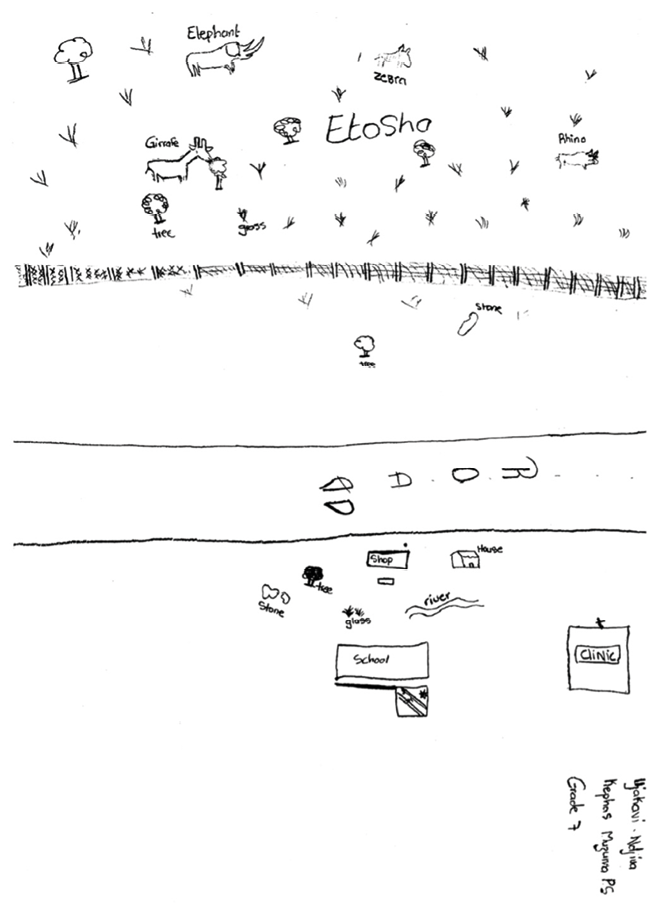
Fig. 14.14 Representative sketch of knowledge about Etosha National Park and Ehi-Rovipuka Conservancy by Grade 7 pupil at Kephas Muzuma Primary School in Otjokavare. © Arthur Hoole, 2008, CC BY-NC-ND 4.0.
In this process 26 of the 34 students included the park fence in their drawings, with most showing “community things” on the school side of the road and wildlife on the park side. When asked if they liked wildlife, 30 of the 34 participants said they did. The pupils were asked which animals they liked or disliked, and results were similar to those shown in Figures 14.8 and 14.9. Interestingly, more pupils liked elephants than disliked them, and more disliked rhino than liked them (contrary to findings shared in Chapter 8). The level of dislike for rhino is intriguing, given extensive efforts in the region by Save the Rhino Trust and other conservation agencies to restore endangered populations. The school teachers and my community assistant clarified that this was not surprising since children are taught by parents from a young age that rhino are dangerous when encountered in the field. The pupils were also asked (afterwards, separately from the mapping exercise) to name the national park in the area and the conservancy. Most (31 of 34) named the Ehi-Rovipuka Conservancy correctly and most (29 of 34) correctly named Etosha National Park. This result suggests a high level of awareness among community youth about the park, the conservancy, conservation and the value of wildlife.
14.5 To conclude: Past and present in conservation in Ehi-Rovipuka
The research shared here is the outcome of attempts to learn more about how villagers in the park-adjacent Ehi-Rovipuka Conservancy view wildlife conservation, and how they participate in, and benefit from, CBNRM, the conservancy and ENP. These insights were sought through a series of questions posed in the structured interviews with 40 villagers, as well as through participant observations, site visits, discussions with community informants, and memory mapping with community elders. Information elicited through this research illuminates both present and past land-use and mobilities through the conservancy and its wider landscape, as well community customs or rules for using wild animals prior to the formation of the conservancy.
Ehi-Rovipuka Conservancy became established particularly in connection with the collaboration of the late Garth Owen-Smith (former Director of the NGO Integrated Rural Development and Nature Conservation, IRDNC) with headman Kephas Muzuma—illustrating the importance of leadership and cross-cultural communication in initiating community-based conservation. In fact, Kephas Muzuma was one of four headmen that Owen-Smith worked with during the 1980s, in the precursor CGG programme (see Chapter 2). The roles of government and NGOs, notably IRDNC, are also reinforced by the villager responses reported in Figure 14.15. There was a fairly high non-response to the question of conservancy start-up (15%), showing that a considerable proportion of respondents did not know this history. A community taskforce of 31 villagers had been created by the traditional authority headman and council, receiving training from IRDNC. This taskforce included both men and women who took the conservancy idea into the villages, built understanding and support for the concept, and helped negotiate the boundaries—described as a protracted process lasting three years. An ancillary question was asked about how the boundaries of the conservancy were established. Those that could reply (63%) recognised a process of negotiations with surrounding communities and TAs by the community task force. A relatively large proportion (43%) did not know how the conservancy boundaries had been formed. Important points of emphasis made by some villagers noted that boundaries defined rights of access to wildlife only and the conservancy included communities that agreed on sharing wildlife. Grazing, water rights and other resource access rights were perceived as not subject to the exclusionary role of the conservancy boundaries. The boundaries are well known at the community level; 80% of the villagers interviewed indicated they knew the boundaries, or at least, the different villages that made up the conservancy.
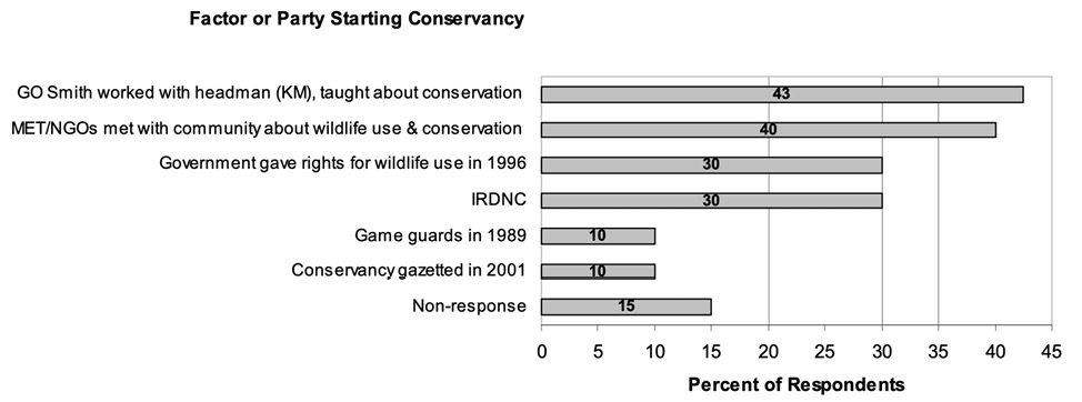
Fig. 14.15 Graph showing respondents’ perceptions of key players and contexts in initiating conservancy organisation. © Arthur Hoole, 2008, CC BY-NC-ND 4.0.
Conservancy establishment clearly has both top-down and bottom-up dimensions (see Chapter 5).
The idea originated and was enabled from outside, and at higher levels of organisation than on the local community level. Yet, there was a high degree of self-organisation at the community level for the implementation of conservancy institutional arrangements, especially boundary negotiation. Ehi-Rovipuka Conservancy has produced some early benefits for its members and a good deal of hope since its formation in 2001. The sustainability of the conservancy model hinges on institutional strengthening in financial management and transparency in governance, as well as strengthened villager participation in decision-making and priority setting for wildlife-based revenues earned by the conservancy. More culturally congruent and appropriate means for participation in decision-making and distribution of benefits are needed (as also argued in Chapter 5).
Constitutionally imposed policies and procedures by central government, such as the conduct of conservancy Annual General Meetings (AGMs) and attainment of set quorums at meetings, need to be replaced or complemented with more consensual decision-making and consultative processes, consistent with ovaHerero traditions. Villagers frequently mentioned the early days of many meetings and consultations at the individual village level, when conservancy formation was being considered and boundaries were being negotiated with neighbouring communities. These approaches have subsequently been diminished and replaced by AGMs and other mandatory features of conservancy constitutions dictated by central government. Ehi-Rovipuka Conservancy has developed an apparently decentralised model of governance on paper, but at the time of the research was not being fully realised in practice.
Developing needed linkages with ENP is key to the future of the conservancy and community well-being. A theory of creating economic incentives for community conservation rests at the heart of CBNRM programmes in Southern Africa.25 Yet, the ovaHerero of Ehi-Rovipuka Conservancy are actively participating in conservation with few tangible economic incentives to date. While certain future benefits sought by villagers are tied directly to economy, they are equally tied to cultural renewal,26 intrinsic values to conserve wildlife, and attaining a greater voice in natural resources management (also see Chapters 5, 6, 12, 13 and 15). Individual conservancies like Ehi-Rovipuka are quite localised wildlife conservation institutions, but connected with many other neighbouring conservancies and nested within the regional distributions and movements of wildlife, upon which each conservancy depends (see Chapter 3).
The rapid scaling-up in the numbers of conservancies suggests a commensurate need for scaling-up of regional institutions and collaborations. The management of wildlife must extend beyond the monitoring of populations to include monitoring and management of habitats (see Chapter 9), especially the connectivity corridors along ephemeral rivers. These conclusions reinforce certain others in addressing alternative approaches to protected areas that recouple social-ecological systems in the course of aiming for biodiversity conservation. More dynamic models are required that place less emphasis on the designation of parks, and more on needed collaborations and partnerships between park agencies, conservation NGOs and communities in living landscapes.
Bibliography
Andersson, C.J. 1861. Lake Ngami or Explorations and Discovery During Four Years of Wanderings in the Wilds of Southwestern Africa. New York: Harper & Brothers.
Berry, H.H. 1997. Historical review of the Etosha region and its subsequent administration as a National Park. Madoqua 20(1): 3–10, https://hdl.handle.net/10520/AJA10115498_453
Berry, H.H., Rocher, C.J.V., Paxton, M. and Copper, T. 1997. Origin and meaning of place names in Etosha National Park. Madoqua 20(1): 13–35, https://journals.co.za/doi/pdf/10.10520/AJA10115498_454
Blaikie, P. 2006. Is small really beautiful? Community-based natural resource management in Malawi and Botswana. World Development 34(11): 1942–57, https://doi.org/10.1016/j.worlddev.2005.11.023
Ehi-Rovipuka Conservancy 2002. Annual Natural Resources Report. Otjokavare, Namibia.
Ehi-Rovipuka Conservancy 2003. Annual Natural Resources Report. Otjokavare, Namibia.
Ehi-Rovipuka Conservancy 2004. Annual Natural Resources Report. Otjokavare, Namibia.
Ehi-Rovipuka Conservancy 2005. Annual Natural Resources Report. Otjokavare, Namibia.
Hauptfleisch, M., Blaum, N., Liehr, S., Hering, R., Kraus, R., Tausendfruend, M., Cimenti, A., Lüdtke, D., Rauchecker, M. and Uiseb, K. 2024. Trends and barriers to wildlife-based options for sustainable management of savanna resources: The Namibian case. In von Maltitz, G.P., Midgley, G.F., Veitch, J., Brümmer, C., Rötter, R.P., Viehberg, F.A. and Veste, M. (eds.) Sustainability of Southern African Ecosystems Under Global Change. Berlin: Springer Nature, 499–525, https://doi.org/10.1007/978-3-031-10948-5_18
Hinz, W.O. 2003. Without Chiefs There Would be No Game: Customary Law and Nature Conservation. Windhoek: Out of Africa Publishers.
Hoole, A.F. 2008. Community-Based Conservation and Protected Areas in Namibia: Social-Ecological Linkages for Biodiversity. Unpublished PhD Thesis, University of Manitoba.
Hoole, A. and Berkes, F. 2010. Breaking down fences: Recoupling social-ecological systems for biodiversity conservation in Namibia. Geoforum 41(2): 304–17, https://doi.org/10.1016/j.geoforum.2009.10.009
Infield, M. 2001. Cultural values: A forgotten strategy for building community support for protected areas in Africa. Conservation Biology 13(3): 800–02, https://www.jstor.org/stable/3061464
Malan, J.S. and Owen-Smith, G.L. 1974. The ethnobotany of Kaokoland. Cimbebasia. (B) 2(5): 131–78.
NACSO 2004. Namibia’s Communal Conservancies: A Review of Progress 2003. Windhoek: Namibian Association of CBNRM Support Organisations.
NACSO, 2006. Namibia’s Communal Conservancies: A Review of Progress and Challenges in 2005. Windhoek: Namibian Association of CBNRM Support Organisations.
Rudner, I. and Rudner, J. 1974[1899]. Journey in Africa Through Angola, Ovampoland and Damaraland 1895-1896 by P. Möller. C. Struik: Cape Town.
Stander P. and Esterhuizen, A. n.d. Detailed Survey on the State of Human Wildlife Conflict in Ehi-rovipuka and Omatendeka Conservancies. Ministry of Environment and Tourism ICEMA Project. Windhoek.
Sullivan, S. 1998. People, Plants and Practice in Drylands: Sociopolitical and Ecological Dynamics of Resource Use by Damara Farmers in Arid North-west Namibia, including Annexe of Damara Ethnobotany. Ph.D. Anthropology, University College London, http://discovery.ucl.ac.uk/1317514/
Sullivan, S. 1999. Folk and formal, local and national: Damara knowledge and community conservation in southern Kunene, Namibia. Cimbebasia 15: 1–28.
Sullivan, S. 2002. ‘How can the rain fall in this chaos?’ Myth and metaphor in representations of the north-west Namibian landscape. In LeBeau, D. and Gordon, R.J. (eds.) Challenges for Anthropology in the ‘African Renaissance’: A Southern African Contribution. Windhoek: University of Namibia Press, 255–265, 315–317.
Sullivan, S. 2005. Detail and dogma, data and discourse: Food-gathering by Damara herders and conservation in arid north-west Namibia. In Homewood, K. (ed.) Rural Resources and Local Livelihoods in Sub-Saharan Africa. Oxford: James Currey and University of Wisconsin Press, 63–99, https://doi.org/10.1007/978-1-137-06615-2_4
World Resources Institute, UNDP, UNEP and World Bank 2005. World Resources 2005: The Wealth of the Poor-Managing Ecosystems to Fight Poverty. Washington: World Resources Institute.
1 Acknowledgements by Arthur Hoole: I wish to acknowledge several indispensable contributions to my research in Namibia. Asser Ujaha of Otjokavare ably served as my field assistant and community interpreter. Village elders the late Langman Muzuma, the late Festus Kaijao Vejorerako and Fanwell Ndjiva shared their remarkable memories through animated conversations and maps they collectively prepared. The villagers of Otjokavare kindly agreed to be interviewed and generously shared their experiences. Leslie Hoole manually recorded every interview I conducted and took every step of our journey in “Etosha-Kunene”. I also thank Ute Dieckmann, Selma Lendelvo and Sian Sullivan for inviting to me participate in this important project. Sian made a remarkable effort to include my research in the book, leading to my inviting her to be named as a co-author.
2 Hoole (2008)
3 Selma Lendelvo, pers. comm. 14.12.2023.
4 See Hoole & Berkes (2010)
6 This is a reference to the Trekboers who had travelled through north-central and north-west Namibia to settle in Angola in the late 1800s, but were encouraged to settle in South West Africa in the late 1920s (see Chapters 1 and 2).
7 Referring to when the farm Kowares was purchased by the then SWA government for the Kaokoland Homeland, following the Odendaal Commission of the early 1960s (see Chapters 2 and 13).
8 In these years the government unit responsible for conservation would have had a different name.
9 See Peter Möller’s narrative in Rudner & Rudner (1974[1899]: 195–96)
10 Andersson (1861: 183–84), Berry (1997: 3)
11 Interview with Garth Owen-Smith, 2007.
12 Ujaha interview, 2007. See Hoole & Berkes (2010) for more details about these mobilities in the first half of the 20th century.
13 Berry et al. (1997)
14 NACSO (2004), NACSO (2006), World Resources Institute (2005)
15 Matongo, 2007, pers. comm.; Greg Stuart-Hill, 2007, pers. comm.
16 Ibid.
17 Similar findings regarding Damara/ǂNūkhoe perceptions of rainfall in driving ecological dynamics in north-west Namibia are documented in Sullivan (2002).
18 Stander & Esterhuizen (n.d.)
19 Ehi-Rovipuka (2002, 2003, 2004, 2005)
20 Stander & Esterhuizen (n.d.)
21 Ibid., Hauptfleisch et al. (2024: 507–11)
22 (2003)
23 As also documented in detail for ǂNūkhoe honey harvesters to the west of Ehi-Rovipuka in Sullivan (1999).
24 As confirmed in research in other areas of Kunene Region (for example, Malan and Owen-Smith 1974; Sullivan 1998, 2005); also see Chapters 12, 13 and 15.
25 Blaikie (2006)
26 Infield (2001)
