
2. Urban Development of Palmyra, Post-war Damage Assessment and Recovery Policy
©2024 Ousama Rumayed, CC BY-NC-ND 4.0 https://doi.org/10.11647/OBP.0412.02
Introduction
Between 2015 and 2017, the Islamic State of Iraq and Syria (ISIS) twice occupied Syria, wreaking deliberate devastation which systematically targeted archaeological monuments without any regard for their cultural, historical, and socio-economic significance. The city of Palmyra, inscribed on the United Nations Educational, Scientific and Cultural Organization (UNESCO) World Heritage List in 1980, tragically found itself on the List of World Heritage in Danger in 2013, alongside five other sites in Syria.
ISIS carried out a systematic campaign to destroy Palmyra’s architectural monuments in an attempt to obliterate the site’s history, resulting in severe damage to several parts of the ancient city. Specifically, Palmyra’s historical park, home to the most significant and magnificent ancient monuments, experienced massive explosions that destroyed many important historical monuments and left others in a state of partial destruction.
In addition to targeting archaeological sites, this violence was also directed at museum staff, facilities, and Palmyra residents, many of whom were displaced during the conflict. All of these events pose a considerable risk to the city’s tangible and intangible heritage.
Recognizing the importance of Palmyra’s revival, there is an urgent need for a recovery plan integrating the master planning process, science-based conservation strategies, and the leveraging of effective partnerships. This plan should aim to provide lasting heritage protection while remaining sufficiently flexible to address the complex challenges posed by this site.
Before any far-reaching proposal can be made for post-war reconstruction, it is essential to collect ample information about each of the archaeological site’s monuments as well as about its historical development, urban style, and construction materials. This knowledge is integral to preserving Palmyra’s authenticity and identity, which must be a priority in all reconstruction, restoration and preservation initiatives.
Historical Background
Palmyra, an iconic archaeological site with evidence of human settlement since the Palaeolithic and Neolithic eras, is one of the important cultural centres of the ancient world. Located in the heart of Syria, its geographical foundation is a natural spring at a mountain crossing in the desert of the Levant. This spring gave rise to a green oasis that became a place of rest between Iraq and the Levant and a caravan station between the Arabian Gulf and Persia and the Mediterranean Sea. It grew steadily along the trade routes, marking the crossroads of several civilisations.1
The history of Palmyra dates back to the late third millennium BC. The name ‘Palmyra’ appears on a plastered clay tablet found in Cappadocia (Anatolia) and in the documents of the Mari kingdom from the reign of Hammurabi in the eighteenth century BC, as well as in Assyrian records dating back to the twelfth century BC.2

Fig. 2.1 Documentation Palmyra by GIS, IT Department. GIS Map by Directorate General of Antiquities and Museums-DGAM, 2014, CC BY-NC-ND.
Palmyra became renowned in the Greco-Roman period during the reign of Odaenathus (AD 252–268), who defeated Shapur, the Persian king, in AD 265. Rome granted him the title of Reformer of the East and the Vice Emperor, with command over the armies in natural Syria. He also assumed the title of King of Kings.3
Following Odaenathus’s murder, his wife, Queen Zenobia, took the throne on behalf of her son, Wahb Allāt, who was eight years old at the time of his father’s death. Zenobia established independence from Rome and ruled over the entire East, from the Gulf and the Levant to Egypt and Anatolia. In AD 271, her armies occupied Syria and Asia Minor, extending her domain to the Bosporus Strait. She and her son adopted the titles of the Roman emperors, which Roman Emperor Aurelian considered a challenge to his authority. He deployed his army to confront Zenobia, forcing her armies to retreat in AD 273–274. After a brutal siege, Palmyra fell, and Aurelian seized its territories.4
In the Umayyad period, Palmyra regained its prominence due to its location between the two al-Hier palaces of Hisham ibn Abd al-Malik.5 However, it lost its status when the Abbasid relocated the caliphate’s capital from Damascus to Baghdad. In the early tenth century AD, Palmyra was struck by a major earthquake that destroyed many of its buildings and most of its inhabitants died beneath the rubble.6
Palmyra went into decline after the Tamerlane invasion of the Levant and the destruction of the cities of the Euphrates with which Palmyra had traded.7
Architectural and Urban Planning of the Ancient Zone
The city developed during the Greco-Roman period, extending from the Temple of Bel to the Afqa spring and encompassing the oasis and the tombs outside the city walls. The hard limestone used to build the facades of the buildings was brought from stone quarries located ten kilometres north of the city.
Practical Methods and Techniques
Palmyra’s urban plan did not follow the Roman orthogonal scheme, unlike the neighbouring city of Dura-Europos. Instead, Palmyra adopted a local urban plan better suited to the high temperature, winds and topography of the terrain, allowing the city to expand beyond its oasis. This was not a disadvantage as many Greco-Roman cities followed their own urban patterns, even Rome itself.
Establishing a new urban settlement included the construction of a broad north-to-south street intended to replace the old convoy route.8 This transverse street had a portico on its eastern and western sides. It originated in the south at the Damascus Gate and the oval area behind it, known as the Oval Forum. Inscriptions on its columns indicate that the transverse street had both commercial and religious functions.9
Given that the western residential area was bordered by underground tombs and rocky highlands, its inhabitants had to expand their settlement eastward. To procure freshwater from the spring, they devised a system for conveying water through an underground canal.10
The second settlement area was established to the east, at the junction where convoys travelling from the east encountered those coming from the Levant. This was where the public square, the Agora, and its warehouse were constructed.11
The grand colonnade is a prime example of a structure representing a major artistic development. The grand monumental colonnaded street, with its covered side passages and subsidiary cross streets, together with the major public buildings, constitute an exceptional illustration of architecture and urban planning at the peak of Rome’s expansion and engagement with the Eastern world.12

Fig. 2.2 Palmyra landscape aerial view. Photograph by DGAM, Archive,
CC BY-NC-ND.
The main colonnaded street, with secondary perpendicular colonnaded streets, connected the major public landmarks, including the Temple of Bel, the Agora, the Theatre, Diocletian’s Camp, other temples and the urban quarters. Architectural ornaments, including unique examples of funerary sculpture, combined Greco-Roman art with indigenous elements and Persian influences, resulting in a profoundly original style. Outside the city’s walls lie remnants of a Roman aqueduct and immense necropolises.13
Palmyra’s architecture exhibited creativity and was adapted to local conditions and constraints. It was neither strictly Hellenistic nor Roman, but instead represented a combination of urbanisation and originality.14
The Urban Situation in Palmyra Since 2013
Terrorism Damage
Palmyra was designated a national heritage site in 1934 and later recognized as a World Heritage site in 1980. Unfortunately, in 2013, it was added to the list of World Heritage sites in Danger, joining five other endangered sites in Syria. On 21 May 2015, the situation in and around Palmyra worsened dramatically when ISIS militants launched an attack on the ancient city, with uncertain consequences.
The city faced an imminent threat to its archaeological heritage as well as to its very survival. The destruction of Palmyra would be a catastrophic loss for all of Syria, erasing an important part of the nation’s history. Moreover, Syrian cultural heritage suffered even greater damage and destruction when organised armed groups of antiquities looters spread throughout the ancient city in the summer of 2013. They conducted various illegal excavations and thefts, engaging in the systematic destruction of dozens of archaeological sites, hills and tombs.15 During 23–27 March 2016, the Syrian armed forces launched a military operation to retake the city and establish control.16
Palmyra was re-occupied by ISIS militants on 11 December 2016 and liberated again by Syrian forces on 1 March 2017. During the 2015–2017 period, the ancient city of Palmyra witnessed the confirmed destruction of many significant landmarks and monuments in a series of major cultural, scientific, and human losses. The following examples illustrate the damage inflicted on Palmyra’s cultural heritage.
The Arch of Triumph, 4 October 2015
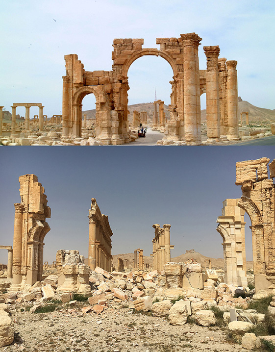
Fig. 2.3 The Arch of Triumph. Damage assessment of Palmyra. Photographs by DGAM, 2017, CC BY-NC-ND.
The Arch of Triumph, also known as the Monumental Arch, is one of the most famous monuments of Palmyra. The uniqueness of this Arch derives from the way the arch transitions between its northern and the southern facades. It also boasts unique ornamentation, with detailed decorative carvings of floral and leaf patterns.
The collapse of its middle spans destroyed the central arch and smaller flanking arches, leaving the columns on all sides standing.17
Temple of Baal-Shamin, 23 August 2015

Fig. 2.4 Temple of Baal-Shamin. Damage assessment of Palmyra. Photographs by DGAM, 2017, CC BY-NC-ND.
The temple of Baal-Shamin, a deity associated with rain and fertility, is located in the northern quarter of the ancient city, northeast of Tetrapylon. The temple is built atop the ruins of an earlier temple and is composed of two courtyards with a cella (10×20 metres) and porticoes. Exemplary of second-century Romano-Syrian architecture, the temple’s cella forms a triangular truss above six adorned columns.
Although the temple’s cella was destroyed, the northern and southern columns just next to the cella survived the explosion and remained in good condition.18
The Cella of Temple of Bel, 28 August 2015

Fig. 2.5 The cella of Temple of Bel. Damage assessment of Palmyra. Photographs by DGAM, 2017, CC BY-NC-ND.
The Temple of Bel is considered one of the most famous religious temples in the ancient East. The temple was surrounded by a sanctuary (205×220 metres) composed of 375 columns. The cella, which only priests were allowed to enter, was situated in the middle of the sanctuary.
Unfortunately, the cella was destroyed, its stones reduced to small fragments scattered around the site.19
Six Tower Tombs, between the End of August and the Beginning of September 2015

Fig. 2.6 Six tower tombs. Damage assesment of Palmyra. Photographs by DGAM, 2017, CC BY-NC-ND.
Among the tomb types of Roman Syria are the curious ‘tower tombs’ of Palmyra, which are unparalleled in the Roman architecture of the Western Empire. Documentation efforts have revealed approximately 180 tower tomb structures in various states of preservation that are still identifiable. The American Schools of Oriental Research (ASOR), based at Boston University, published an update on the situation in Palmyra, including satellite imagery showing six tower tombs in the city that had been completely destroyed by ISIS militants.20
The Tetrapylon and the Roman Theatre, between 26 December 2016 and
10 January 201721

Fig. 2.7 The Tetrapylon. Damage assessment of Palmyra. Photographs by DGAM, 2017, CC BY-NC-ND.
The Tetrapylon stands on an oval square in the middle of the colonnade street to the northwest. It comprises four square blocks (10×10 metres), each seventy-five centimetres high, supporting four two-meter granite Corinthian columns. These sets of columns uphold a decorative ceiling. The Tetrapylon served a purely ornamental purpose, designed to conceal the ten-degree incline of the colonnade street.22
Notably, fifteen columns of the Tetrapylon are replicas. The original ceiling was destroyed, while the bases of the columns are intact and four are still standing in place.23

Fig. 2.8 The Roman theatre. Damage assessment of Palmyra. Photographs by DGAM, 2017, CC BY-NC-ND.
The theatre is located on the left side of the colonnade street between the Tetrapylon and the Triumphal Arch. It has a semi-circular design stretching fifty meters, with thirteen levels of tiered seating for the audience and a facade that stands behind a rectangular platform (9.5×45.5 metres), which is 1.95 metres above the orchestra pit.
During the ISIS occupation of the city in January 2017, the theatre was damaged, resulting in the destruction of a portion of the upper niche in the facade and partial damage to the platform.
The Citadel of Palmyra

Fig. 2.9 The Citadel of Palmyra. Damage assessment of Palmyra. Photographs by DGAM, 2017, CC BY-NC-ND.
The Palmyra Citadel contained a series of self-contained interior units with a regular outer envelope, completely vaulted inside on different horizontal planes and surrounded by defensive perimeter walls. There were no large open spaces inside, where sectors and rooms with different functions were arranged along central passageways. The original construction included eight towers connected by a defensive wall, forming a roughly triangular perimeter envelope.24
On 21 September 2015, rocket attacks caused extensive damage to the castle’s outer walls, affecting twenty-five percent of its walls.
Palmyra’s Current Urban Situation
In wartime, cities must adapt to the circumstances of conflict. This necessitates certain changes in order to maintain control over and defend territories. During a visit to Palmyra in 2017, after the city’s liberation, it was observed that the road adjacent to the archaeological site was used by tanks and military vehicles. In the past, flying over Palmyra was restricted to protect the city’s heritage from any vibration caused by planes.
Moreover, the appearance of Palmyra itself has been altered by shelling, clashes and mine explosions during clearance operations. The military presence within the city, intended to ensure its security, has led to major changes in the structure of the archaeological site and its surroundings. For instance, new infrastructure was constructed to facilitate transportation between Palmyra citadel and Al Badya Police Station in the modern city located to the east of the northern tombs.
The new road, visible in satellite imagery, was constructed between 1 September 2012 and 14 November 2013 and remained in use until 26 October 2014. Extending from where the original road to the citadel branches toward the communications mast, the new road cuts through the north-western and northern necropolises down to the tarmac road on the eastern edge of the modern town of Tadmur. The road is approximately 2.4 kilometres long, with a secondary section stretching 580 metres.25
The 20 February 2014 image shows several site disruptions which occurred prior to ISIS occupation. Banks have been erected along the site’s border with the modern town and up the western ridge toward the fortress.
A clearing with surrounding banks has been created below the fortress hill, just west of the southwest corner of the racetrack. There are rectangular and circular banked enclosures on and partly inside the racetrack. A wide straight track has been bulldozed diagonally from the museum to the southern ridge of the fortress, where it branches, with one part leading up to the fortress road and another to the hill behind the Diocletian Camp, where a defensive position and possibly a tank are visible. Finally, a deep trench, seventy metres long and walled on three sides (apart from the northwest), has been dug from northwest to southeast just south of the Nabo Temple.26
The primary danger of this path stems from its location, as it passes through an area containing numerous ancient tombs. Reports indicate that archaeological remains along its trajectory, specifically tomb foundations, were removed during its construction.
Some archaeological stone blocks have been relocated for defensive purposes. Additionally, levees of various heights have been created in multiple locations near the archaeological site. This has not only altered the site’s appearance but may also have led to the clearance of certain archaeological layers.
Recovery Vision and Planning
This vision sets out the methods and techniques that should be applied in accordance with the international charters and guidelines adopted for the technical conservation and ongoing care of the Palmyra World Heritage Site. The ‘Recover Plan’ requires a long-term approach to projects, with due consideration accorded to proper conservation techniques, economic concerns and the need to raise social awareness about management and care.
The plan should represent an integrated process of master-planning, scientific conservation, community involvement and the establishment of effective partnerships. It must serve to provide enduring protection while remaining sufficiently flexible to address the challenges posed by the site.27
Vision
The vision for Palmyra’s recovery is the starting point for planning the site’s future. The recovery of Palmyra must be approached in a way that balances the evolving functional needs of the community with the overriding commitment to preserving the historical, environmental and symbolic significance of the site.28
Three paradigm shifts have been recognised as crucial.
- First, the importance of considering the economic, social, and environmental dimensions of sustainability during the reconstruction of the historic urban area was underscored.
- Second, understanding the heritage as a ‘living urban context’, or ‘a historic urban landscape’, as formalised in 2011 by the Recommendation on the Historic Urban Landscape (HUL), was emphasised, albeit before this document was officially issued.
- Third, a clear indication for reconstruction has been formulated in the context of the heritage definition criteria for relisting in the 2018 Warsaw Recommendation on Recovery and Reconstruction of Cultural Heritage.
Key Objectives
1. Conserving the Heritage and Memory of the Site
The most pressing objective is to identify the monuments needing urgent repair, take temporary security measures for consolidating them, document their current condition and develop projects for their restoration. Several other urgent initiatives are required in order to safeguard the historical values and enable the restoration of both the monuments and the urban fabric. In particular, the following interventions are urgently needed:
- Consolidation of damaged buildings: Restoring the majority of the destroyed buildings and structures requires studies, design work and careful reconstruction practices, which will take time. These restorations will only be possible in the mid‐ and long term. Therefore, it is essential and urgent to consolidate the structures to prevent further collapses and prepare for future restoration work.
- Protection of ruins: The ruins of buildings and structures scheduled for later intervention must be effectively protected and enclosed to prevent the removal of materials and decorative elements. Conservation plans should define the main conservation, excavation and presentation strategies and include provisions on urban development regulations and visitor arrangements.
2. Empowering the Local Community
Intangible cultural values rooted in community life were also severely impacted during the conflict. The displacement of people and communities, the destruction of religious and cultural institutions and local facilities, and the collapse of markets for cultural goods and services have affected age‐old cultural values and practices.
A full understanding of the post-conflict situation is necessary to define policies and actions. To achieve this, a map of all the city’s existing cultural assets should be created, to include all cultural, social and economic resources, community centres and local skills.
This activity will facilitate stakeholder engagement in the reconstruction and recovery process and optimize the use of local cultural and technical resources.
Developing civic engagement tools is essential to foster participation, mobilise the population and speed‐up the reconstruction and recovery process. Potential initiatives include the following:
- Organising local awareness campaigns to inform the population about the progress of works and initiatives and rally support for projects of collective interest.
- Promoting participation mechanisms to involve local associations and communities in the decision‐making process in order to fully incorporate the views and needs of the population.
- Conducting training and capacity-building workshops focused on local communities and their empowerment.
- Facilitating technical and on‐the‐job training programs to build local capacities with regard to construction and restoration works, surveying activities, documentation management and cultural initiatives management.
- Supporting cultural community projects involving the resident population and displaced persons to foster dialogue and social inclusion.
- Promoting youth programs in collaboration with schools and universities to encourage engagement, entrepreneurship, and artistic initiatives among young people.
- Organising cultural programs and initiatives aimed at preserving and reviving local traditions.29
The plan’s development must be discussed and negotiated with professional planners, technical experts, civil society organisations, NGOs, other representative bodies and affected citizens and businesses.
3. Developing Short- and Long-term Integrated Emergency
Preventive Conservation
In planning and implementing the reconstruction and recovery of Palmyra, the 2011 UNESCO Recommendation on the Historic Urban Landscape provides a foundational approach. Particular attention is given to the following aspects:
- Understanding the complex layering of historical typologies and morphologies.
- Preserving the sense of place and visual relationships in historic areas, open spaces and the urban skyline.
- Safeguarding traditional expressions and values, as well as the related crafts and cultural industries.
- Respecting the diversity of expressions and identities of different communities.
A project master plan alone cannot address all aspects of the site before conservation efforts are initiated to prevent further deterioration. This study identifies the following prerequisite tasks:
- Establishing conservation procedures for defining priorities, roles and the selection of implementing partners.
- Developing a short-term emergency and preventive conservation plan for urgent repairs, prioritising monuments at immediate risk due to structural problems.
- Implementing documentation, publication procedures, scientific and archival research and inventory procedure studies to gain a better understanding of buildings and acquire precise information on matters such as structural resistance.
- Securing projects for the comprehensive conservation of monuments and the redesigning and improvement of existing infrastructure.30
Recovery Plan Policy
Strengths, Weaknesses, Opportunities and Threats (SWOT) analysis is a strategic planning technique designed for use in the preliminary stages of the decision-making processes and can be used to evaluate the strategic position of recovery plan policy. It is intended to specify the objectives of the recovery plan policy and identify the internal and external factors that facilitate or hinder the achievement of the stated objectives.
Table 2.1 Characteristics of the Palmyra site within the framework of
SWOT analysis.
|
Strengths |
Weaknesses |
|
(1) Extensive national support for the plan (2) Global scientific repute and appeal to national and international donors |
(1) Conservation issues with certain monuments (2) Absence of comprehensive conservation planning (3) Lack of resources, expertise and workmanship (4) Insufficient data (5) Inaccessibility of previous reports (6) Lack of suitable accommodation and working conditions (7) Economic constraints (8) Absence of a local antiquities department |
|
Opportunities |
Threats |
|
(1) Attracting national and international funds and resources (2) Generating employment (3) Promoting the educational and cultural values of the site’s archaeological landscape (4) Increasing local and public awareness and interest in the site (5) Enhancing conservation through monitoring, diagnosing and restoration (6) Developing technical capacities (7) Fostering international technical cooperation (8) Improving governance and policies for the site |
(1) Decreased financial support. (2) Poor technical infrastructure (3) Lack of sustainable management and future planning (4) Insufficient management system for the monuments, which are a part of the World Heritage Property31 |
Recovery Plan Tools
Informed by the SWOT analysis, several tools and strategies emerge that can be of use in the development of an immediate conservation program to prevent further deterioration of Palmyra’s heritage pending a long-term recovery plan. In terms of knowledge and planning, databases of archaeological and architectural documentation as well as the legal and administrative aspects of the reconstruction and recovery plan should be created, in addition to an up-to-date database of cultural heritage damage assessments in the ancient city. Additionally, comprehensive cultural mapping should be undertaken, encompassing cultural infrastructure, organisations, activities and industries, accompanied by technical for all necessary restoration and rehabilitation works.
At the regulatory level, building and zoning codes must be modified based on reconstruction and recovery efforts. A specialised office should be established to expedite the issuance of permits and oversee an effective inspection process for building safety certification. At a later stage, a comprehensive management plan for the World Heritage Site should be drafted, implemented and adequately monitored.
Financial tools which could be utilised in these processes include innovative, guaranteed microcredit systems as well as special heritage conservation incentives and the harnessing of international partnerships and cooperation.
Master Plan
The master plan provides a vision and framework to guide the recovery phase. It establishes the identity, history, authenticity and outstanding value of the site, defining the objectives and outlining the scope, projected costs and expected outputs of the project.
The master plan aims to articulate the conservation and presentation priorities and principles and integrate conservation, presentation and development policies. It should specifically focus on guiding medium and long‐term decisions on the site’s restoration, reconstruction, rehabilitation and regeneration.
Furthermore, based on public consultations, a restoration ‘philosophy’ should be adopted, adhering to international restoration standards and approaches and supported by international expertise.
The plan should aim to facilitate public and private initiatives in areas in need of rehabilitation by creating suitable conditions for the investment of funds by private actors and the financial system.32
The vision, guiding principles, goals, and strategies outlined in the master plan should be based on the following principles:
- A successful vision for post-war reconstruction depends on a broad scientific consensus at the national and international levels, including among national authorities with members of scientific advisory boards, International Council on Monuments and Sites (ICOMOS), UNESCO and experts who participated in the archaeological missions at the site.
- Effective archiving and documentation are essential to fully understanding the site’s needs.
- Urgent intervention must be undertaken, accounting for external factors such as looting.
- Damage evaluation must include an analysis of techniques and an assessment of materials science, encompassing both existing monuments and all conservation intervention proposals and materials.
- Diagnosing and surveying the archaeological site, the oasis, and the surrounding areas are necessary.
- Efforts to garner national and international financial and technical support are essential.
- Rebuilding the site’s image is crucial to mobilise and raise awareness among Palmyra residents concerning conservation issues and the importance of their shared heritage.33
Conclusion and Lesson Learned
Recently, several World Heritage Sites and historically significant urban areas have been affected by disasters or conflicts. Recent examples include cities like Katmandu in Nepal, Port‐au-Prince in Haiti, and Christchurch in New Zealand, struck by natural disasters, as well as cities like Beirut in Lebanon, Sarajevo in Bosnia and Herzegovina and Timbuktu in Mali, affected by conflict. These cases can serve as valuable references in devising a recovery plan for Palmyra.
The reconstruction and recovery plan for Palmyra must draw upon the experience gained in the last decades in addressing the needs of urban communities and historic urban areas affected by crises. The objective is to preserve the heritage values that constitute the most important legacy and source of identity of this World Heritage Site, while maintaining a balance between place‐based and people‐based policies. In other words, physical reconstruction should not be undertaken without full citizen participation and the implementation of policies to support the livelihoods of the original population.
Actively engaging the population in the reconstruction process is the key to mobilising the technical skills and financial commitments needed for a speedy recovery. While addressing humanitarian needs must be a priority, especially in the early phases after a crisis, the reconstruction and recovery process should begin by restoring essential monuments and urban areas that play a significant role in community life.
As historic cities emerge from armed conflicts, they struggle with the imperative to foster reconciliation within their communities, particularly where crises have impacted the core of local identities. The recovery of cultural heritage emerges from a common vision, which is then linked to the broader vision of post-war reconstruction. This should seek not only to revitalize economic and social development but also to foster an environment of peace to avert the outbreak of renewed violence. The reconstruction of the Mostar Bridge in Bosnia and Herzegovina after its destruction in 1993 exemplifies the value of heritage reconstruction in reconciling communities and rebuilding local identity.
Ultimately, the vision for Palmyra’s recovery should entail establishing an effective management system and developing a master plan for reconstruction and recovery. This should be guided by a flexible strategy and SMART objectives, which should be specific, measurable, achievable, relevant and time-bound. SWOT analyses can be a valuable tool in recovery processes and heritage conservation, contributing to effective and equitable program implementation.
The reconstruction and recovery of Palmyra is a major challenge for the Syrian people and their government. Substantial effort and financial resources are required to restore monuments, rebuild urban infrastructure, stimulate a sustainable economy and rehabilitate social life and societal cohesion.
Bibliography
Abdulhak, Salim, ‘Palmyra in the Architecture and Urbanism of the First Centuries AD’, in Palmyra and the Silk Road, International Colloquium, Palmyra, 7–11 April 1992 (Damascus: DGAM, 1996), pp. 224–26.
Abdulkarim, Maamoun, The Syrian Cultural Heritage in Palmyra Faces Challenges and Risks (Damascus: DGAM, 2015).
Andrade, Nathanael J., Zenobia, Shooting Star of Palmyra (London: Oxford University Press, 2018).
Ball, Warwick, Rome in the East, The Transformation of an Empire (London: Routledge, 2000).
Bounni, Adnan, Palmyre. Histoire, Monuments et Musée (Damascus: n.p., 1982).
Browning, Iain, Palmyra (London: Chatto & Windus, 1979).
Bylinski, Janusz, ‘Qal’at Shirkuh at Palmyra: A Medieval Fortress Reinterpreted’, Bulletin d’études orientales, Institut Francais du Proche-Orient, 51 (1999), 151–208.
Colledge, Malcolm, ‘Roman Influence in the Art of Palmyra’, in Palmyra and the Silk Road, International Colloquium, Palmyra, 7–11 April 1992 (Damascus: DGAM, 1996), pp. 363–71.
Directorate General of Antiquities and Museums-DGAM, ISIS Destroys the Arch of Triumph in Palmyra (Damascus: DGAM, 2015).
DGAM, ISIS Setting up Explosives and Destroying the Sella of Bel Temple in Palmyra (Damascus: DGAM, 2015).
DGAM, New Destruction at Palmyra: Tetrapylon and the Roman Theater (Damascus: DGAM, 2015).
DGAM, Palmyra: ISIS Blown up Baal-Shamin Temple (Damascus: DGAM, 2015).
DGAM, Satellite Imagery of 6 Tower Tombs in Palmyra Destroyed by ISIS (Damascus: DGAM, 2015).
DGAM, Ancient City of Palmyra is Being Restored (Damascus: DGAM, 2016).
DGAM, Latest News from Palmyra (Damascus: DGAM, 2017).
DGAM, State Party Report, on the State of Conservation of the Syrian Cultural Heritage Sites (Damascus: DGAM, 2020).
Intagliata, Emanuele E., Palmyra after Zenobia 273–750. An Archaeological and Historical Reappraisal (Oxford: Oxbow Books, 2018), https://doi.org/10.2307/j.ctt2272712
Mari, Eid, ‘Palmyra as an Important Station on the Caravan’s Road During the Second Millennium’, in Palmyra and the Silk Road, International Colloquium, Palmyra, 7–11 April 1992 (Damascus: DGAM, 1996), pp. 135–37.
Municipality Administration Modernization (MAM), Palmyra Region Strategic Action Plan a Strategy for Sustainable Development (Syria: n.p., 2009).
Schou, Torbjørn Preus, Catalogue of Archaeological Site Integrity Violations in Syria 2010–2016 (Syria: Shirīn–Syrian Heritage in Danger: An International Research Initiative and Network, 2016).
Sommer, Michael, Palmyra: A History (New York, London: Taylor & Francis, 2018).
Teixidor, Javier, A Journey to Palmyra (Leiden: Koninklijke Brill NV, 2005).
UNESCO, Recommendation on the Historic Urban Landscape (Paris: UNESCO, 2011).
United Nations Institute for Training and Research (UNITAR), Satellite-Based Damage Assessment to Cultural Heritage Sites in Syria (n.p.: UNITAR, 2014), https://unosat.web.cern.ch/unitar/downloads/chs/FINAL_Syria_WHS.pdf
Wielogsz, D., ‘Tadmor nel deserto. La città greco-romana’, in Siria: Dalle antiche città-stato alla primavera interrotta di Damasco, ed. by M. Giudetti (Milan: Jaca Book, 2006), pp. 41–60.
1 Eid Mari, ‘Palmyra as an Important Station on the Caravan’s Road During the Second Millennium’, in Palmyra and the Silk Road, International Colloquium, Palmyra, 7–11 April 1992 (Damascus: DGAM, 1996), pp. 135–37.
2 Warwick Ball, Rome in the East, The Transformation of an Empire (London: Routledge, 2000), p. 74.
3 Nathanael J. Andrade, Zenobia, Shooting Star of Palmyra (London: Oxford University Press, 2018), pp. 117–20.
4 Javier Teixidor, A Journey to Palmyra (Leiden: Koninklijke Brill NV, 2005), p. 220.
5 Emanuele E. Intagliata, Palmyra after Zenobia 273–750. An Archaeological and Historical Reappraisal (Oxford: Oxbow Books, 2018), p. 85, https://doi.org/10.2307/j.ctt2272712
6 Michael Sommer, Palmyra: A History (New York, London: Taylor & Francis, 2018), p. 220.
7 Adnan Bounni, Palmyre. Histoire, Monuments et Musée (Damascus: n.p., 1982), pp. 120–30.
8 Salim Abdulhak, ‘Palmyra in the Architecture and Urbanism of the First Centuries AD’, in Palmyra and the Silk Road, pp. 224–26 (p. 224).
9 D. Wielogsz, ‘Tadmor nel deserto. La città greco-romana’, in Siria: Dalle antiche città-stato alla primavera interrotta di Damasco, ed. by M. Giudetti (Milan: Jaca Book, 2006), pp. 41–60.
10 Abdulhak, ‘Palmyra in the Architecture and Urbanism of the First Centuries AD’, pp. 224–26.
11 Ibid., pp. 263–85.
12 Sommer, Palmyra: A History, p. 171.
13 Ball, Rome in the East, p. 74.
14 Malcolm Colledge, ‘Roman Influence in the Art of Palmyra’, in Palmyra and the Silk Road, pp. 363–71.
15 Maamoun Abdulkarim, The Syrian Cultural Heritage in Palmyra Faces Challenges and Risks (Damascus: DGAM, 2015).
16 DGAM, Ancient City of Palmyra is Being Restored (Damascus: DGAM, 2016).
17 DGAM, ISIS Destroys the Arch of Triumph in Palmyra (Damascus: DGAM, 2015).
18 DGAM, Palmyra: ISIS Blown up Baal-Shamin Temple (Damascus: DGAM, 2015).
19 DGAM, ISIS Setting up Explosives and Destroying the Sella of Bel Temple in Palmyra (Damascus: DGAM, 2015).
20 DGAM, Satellite Imagery of 6 Tower Tombs in Palmyra Destroyed by ISIS (Damascus: DGAM, 2015).
21 DGAM, New Destruction at Palmyra: Tetrapylon and the Roman Theater (Damascus: DGAM, 2015).
22 Iain Browning, Palmyra (London: Chatto & Windus, 1979), p. 132.
23 DGAM, Latest News from Palmyra (Damascus: DGAM, 2017).
24 Janusz Bylinski, ‘Qal’at Shirkuh at Palmyra: A Medieval Fortress Reinterpreted’, Bulletin d’études orientales, 51 (1999), 151–208.
25 UNITAR, Satellite-Based Damage Assessment to Cultural Heritage Sites in Syria (n.p.: UNITAR, 2014), https://unosat.web.cern.ch/unitar/downloads/chs/FINAL_Syria_WHS.pdf
26 Torbjørn Preus Schou, Catalogue of Archaeological Site Integrity Violations in Syria 2010–2016 (Syria: Shirīn–Syrian Heritage in Danger: An International Research Initiative and Network, 2016), p. 18.
27 DGAM, State Party Report, on the State of Conservation of the Syrian Cultural Heritage Sites (Damascus: DGAM, 2020), p. 7
28 Ibid., p. 8.
29 UNESCO, Recommendation on the Historic Urban Landscape (Paris: UNESCO, 2011), p. 24.
30 DGAM, State Party Report, p. 7.
31 Ibid., p. 9.
32 Municipality Administration Modernization (MAM), Palmyra Region Strategic Action Plan a Strategy for Sustainable Development (Syria: n.p., 2009), p. 199.
33 DGAM, State Party Report, p. 9.